1760 Gibson / Gentleman's Magazine Map of North Polar Region
NorthPole-gibson-1760$300.00

Title
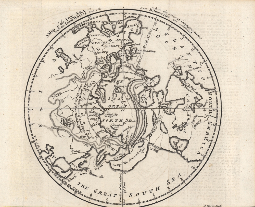
A Map of the Icy Sea in which the several Communications with the Land Waters and other new Discoveries are exhibited.
1760 (undated) 8 x 8 in (20.32 x 20.32 cm) 1 : 70000000
1760 (undated) 8 x 8 in (20.32 x 20.32 cm) 1 : 70000000
Description
A fascinating c. 1760 John Gibson map of the North Polar region that appeared in the London Gentleman's Magazine. Highlighting the latest discoveries by several nations as well as a host of speculations, it provides insight into the extent and limits of geographical knowledge at the time.
A Closer Look
This map is based on the work of the French geographers Phillipe Buache and Jean Palairet, for whom Gibson had engraved other maps. It posits a polar Northwest Passage from Portugal to Japan running north of Greenland, a land bridge between Greenland and Alaska (a 'peninsula discovered 1753'), and an apocryphal Sea of the West ('West Sea') in western North America. These errors aside, it is notable for providing an up-to-date combination of geographic knowledge from Russian, English, French, and other expeditions. The location of the great Dutch whaling center of Spitzbergen and of 'a Dutch ship in 1670' are noted, hinting at the early history of north polar exploration.The Sea of the West
Numerous maps of North America and the Arctic issued in the mid to late 19th century feature a massive speculative inland sea in the American Pacific Northwest referred to as the Sea of the West (Mer L'Ouest). The earliest printed map to feature the sea was Jean-Baptiste Nolin’s 1742 L’Amerique ou le Nouveau Continent. Nolin likely copied the relevant cartography from an unpublished manuscript discovered in Guillaume De l’Isle (1675 - 1726) posthumous papers - although it seems likely that he either did not see the De L'Isle manuscript clearly or only heard about it, as his cartography is substantively different from that proposed by De L'Isle. The notion nonetheless achieved vigorous support in intellectual circles, as it made the idea of an inland naval passage through North America seem more practical. In 1752, it was embraced by Jacques Nicholas De l’Isle, Guillaume's younger brother, and Philip Buache, who boldly presented the sea in conjunction with the high-integrity discoveries of Vitus Bering's Great Northern Expedition (1733 - 1743) in the Siberian Arctic. Although De l’Isle and Buache were immediately attacked over the sea of the west by other intellectuals, the Sea of the West appeared on many maps until generally disproved by the expeditions of Cook, Vancouver, and La Perouse.Publication History and Census
This map was engraved by John Gibson and was first published in the Gentleman's Magazine in 1760. It appeared in Scots Magazine the same year and was later republished in the Gentleman's Magazine to accompany an account of Phipps' 1773 polar expedition. It was subsequently republished in several works, including the official account of Phipps' expedition (The journal of a voyage undertaken… for making discoveries towards the north pole) and David Henry's An Historical Account of all the Voyages round the World, performed by English Navigators. As a result, it is the subject of six unique listings in the OCLC, but is quite rare regardless, being independently cataloged among the holdings of 13 institutions worldwide.CartographerS
John Gibson (1724 – 1773) was an English map engraver active in London at the end of the 18th century. Gibson was the son of a locksmith. In 1739 he apprenticed to John Blundell as a stationer of Grub Street. Gibson proved a fine engraver and was much in demand by London map publishers. During his career he produced thousands of maps and was admired as a skilled engraver and sculptor. Among others, he engraved for Emanuel Bowen, Robert Sayer, Jean Palairet, John Rocque, Andrew Dury, and Benjamin Martin. His best known work was prepared in conjunction with Gentleman's Magazine. Gibson, sadly, was not as astute in his fiscal affairs as with the engravers pen and consequently spent much of his life consigned to debtor's prison. More by this mapmaker...
The Gentleman's Magazine (fl. c. 1731 - 1922) was an English periodical founded by visionary Edward Cave. Considered the world's first monthly general interest magazine, GM was also known as Trader's Monthly Intelligencer. Cave's innovation was to create a monthly digest of news and commentary on any topic the educated public might be interested in, from commodity prices to Latin poetry. It carried original content from a stable of regular contributors, as well as extensive quotes and extracts from other periodicals and books. Cave, who edited The Gentleman's Magazine under the pen name "Sylvanus Urban", was the first to use the term "magazine" (meaning "storehouse") for a periodical. The iconic illustration of St John's Gate on the front of each issue (occasionally updated over the years) depicted Cave's home, in effect, the magazine's "office". Among the important firsts of the The Gentleman's Magazine are the first use of the term "magazine" for a periodical and the first regular employment of lexicographer Samuel Johnson. Learn More...
Condition
Very good. Trimmed closely at bottom.
References
OCLC 316620338, 10670611, 994592929, 994508104, 966292196, 795580876.