This item has been sold, but you can get on the Waitlist to be notified if another example becomes available, or purchase a digital scan.
1873 Dripps Pocket Map of New York City, Brooklyn and Hoboken
NYC-dripps-1873$500.00

Title
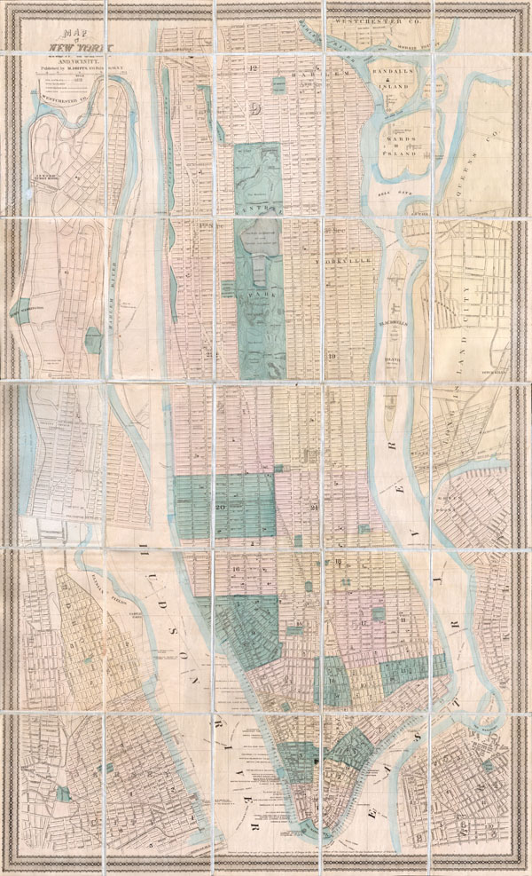
Map of New York City and Vicinity.
1873 (dated) 37.5 x 23 in (95.25 x 58.42 cm)
1873 (dated) 37.5 x 23 in (95.25 x 58.42 cm)
Description
This is a rare pocket map of New York City by M. Dripps. Covers the entire island of Manhattan as well as parts of Brooklyn, Queens, Hoboken and Jersey City. Shows the city in considerable detail with all streets and, in Manhattan, block numbers clearly shown. Labels most of the peers in lower Manhattan and shows numerous individual buildings with identifying numbers. Where Columbia University now stands, this map reveals a 19th century Lunatic Asylum. In Queens, labels Hunters Point and shows the beginnings of the Long Island Railroad. Dated 1973 under the title, but the copyright at the bottom center reads, 'Entered according to Act of Congress in the year 1865 by M. Dripps in the Clerks Office of the District Court for the Southern District of New York'
This map was popular throughout the mid to late 19th century when it was commonly issued folded into with Valentine's Manual of the Common Council of New York. This map, however is a rare independent issue. Unlike the Valentine variations, our map is bound into its own special binder. The map is dissected and mounted on linen in 30 sections for easy folding. Ultimately this is an unusual and very difficult to find variant on an important 19th century New York Map.
This map was popular throughout the mid to late 19th century when it was commonly issued folded into with Valentine's Manual of the Common Council of New York. This map, however is a rare independent issue. Unlike the Valentine variations, our map is bound into its own special binder. The map is dissected and mounted on linen in 30 sections for easy folding. Ultimately this is an unusual and very difficult to find variant on an important 19th century New York Map.
Cartographer
Matthew Dripps (1812 – April 9, 1896) was an Irish-born American mapmaker active in Philadelphia and New York during the second half of the 19th century. Dripps was born in Gracefield, Ireland. In Ireland, probably Belfast, he worked as a grocer. Dripps immigrated to American from Belfast on the Patrick Henry in 1849, arriving in Philadelphia, where he connected with the Reformed Presbyterian Church and worked briefly as a tax collector. His earliest recorded maps, depicting Philadelphia, appeared during this period. Dripps relocated to Brooklyn, New York in 1850, setting up shop as a map publisher. His two largest maps were published in the following years, 1850 and 1851, and combine to form an enormous map of Manhattan. These gained him the attention of the City Council, who used his maps for census and government work. Afterwards, he issued other large format New York City and Brooklyn maps as well as smaller maps for the New York City Clerk's office. He was married to Ameila Millar Dripps with whom he had six children, among them Amelia Dripps and the clergyman Joseph Frederick. Dripps is interred at Greewood Cemetery, Brooklyn. More by this mapmaker...
Condition
Very good condition. Dissected and mounted on linen in 30 sections. Original green linen binder attached.
References
Haskell, Daniel Card (ed.), Manhattan Maps; A Co-operative List, New York: The New York Public Library, 1155.