1876 Disturnell City Map or Plan of New York City Illustrating School Districts
NYCSchoolDistricts-disturnell-1876$450.00
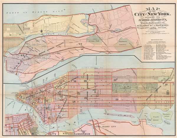

Title
Map of the City of New York, Showing the School Districts, Wards, Railroads, etc.
1876 (dated) 19.25 x 25 in (48.895 x 63.5 cm) 1 : 22900
1876 (dated) 19.25 x 25 in (48.895 x 63.5 cm) 1 : 22900
Description
This is an 1876 John Disturnell city map or plan of New York City. The map depicts the city in two halves: the portion of Manhattan island above 130th Street and the Bronx north to Woodlawn Heights is illustrated on the top half of the sheet, while Manhattan below 129th Street to the Battery and portions of Brooklyn, Williamsburg, and Long Island City are illustrated on the bottom half. Highly detailed, city wards in both New York City and Brooklyn are labeled, along with each of the eight school districts in New York City. The school districts to not appear to be as defined as the city wards, making it more difficult to determine exactly what parts of New York City constituted which school district. Ferry routes across the East River are illustrated and labeled, while ferries across the Hudson are simply labeled. Streets throughout New York City and Brooklyn are labeled, along with Central Park in Manhattan and the Navy Yard in Brooklyn. At this point in New York City's history, the five boroughs had not been consolidated yet, so New York and Brooklyn were still two separate cities.
This map was published by John Disturnell in 1876.
This map was published by John Disturnell in 1876.
Cartographer
John Disturnell (1801-1877) was a New York book and map publisher operating gin the early to middle 19th century. Disturnell worked with various engravers and cartographers over the years including Calvin Smith, J. H. Young, and G. E. Sherman as well as the Ensign, Bridgeman and Fanning group. His primary focus seems to have been New York and vicinity, however, his most significant contribution to U.S. history came from the opposite side of the continent. When Nicholas P. Trist was sent to Mexico to negotiate the 1847 Treaty of Guadeloupe Hidalgo which defined the Mexican-American border at the end of the Mexican-American War, he carried with him Disturnell's Map of America. This map, among other inaccuracies, located El Paso a whopping 34 miles north and 100 miles east of its true location. Since Trist based the border treaty on mileages from El Paso, the obvious subsequent confusion lead to the conflicts that were to follow. The border problems between the United States and Mexico that resulted from this error were not resolved until 1963. More by this mapmaker...
Condition
Very good. Backed on archival tissue for stability. Blank on verso.
References
Haskell, D., Manhattan Maps: A Co-operative List, 1296.