This item has been sold, but you can get on the Waitlist to be notified if another example becomes available, or purchase a digital scan.
1806 Cary Map of New England, New York, Pennsylvania, New Jersey and Virginia
NYVTNVA-cary-1806$270.00

Title
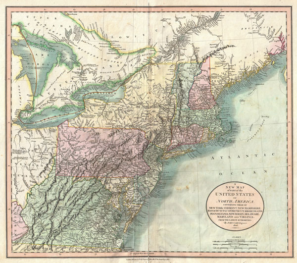
A New Map of Part of the United States of North America, Containing those of New York, Vermont, New Hampshire, Massachusets, Connecticut, Rhode Island, Pennsylvania, New Jersey, Delaware, Maryland and Virginia.
1806 (dated) 18 x 20.75 in (45.72 x 52.705 cm)
1806 (dated) 18 x 20.75 in (45.72 x 52.705 cm)
Description
Published by John Cary in 1806, this is one of the most interesting atlas maps of the northeastern parts of the United States to appear in the early 19th century. Covers from Lake Huron southward as far as Virginia and North Carolina and eastward as far as the Atlantic Ocean. Includes the modern day states of Maine, New Hampshire, New York, Vermont, Massachusetts, Connecticut, Rhode Island, Pennsylvania, New Jersey, Maryland, Delaware, Virginia, West Virginia and Ohio as well as parts of Ontario and Quebec. The most interesting part of this map is the Northwest which is dedicated to the Great Lakes and the Western Territory. Notes the Connecticut's Western Reserve in what is today Ohio. The reserve, formally ceded to Connecticut after the Yankee-Pennamite Wars, was the last remnant of Connecticut's old colonial sea-to-sea grant of all territory falling between the 41st and 42nd parallels. Includes numbers references to the American Indian nations occupying the region, including the Chippewa, the Ootawas, and the Six Nations. Also notes the important cod fishing banks off Massachusetts and Maine. Prepared in 1806 by John Cary for issue in his magnificent 1808 New Universal Atlas.
Cartographer
John Cary (1754 - 1835) was a London based cartographer active in the early part of the 19th century. Ronald Vere Tooley, the prominent English map historian, writes of Cary, "As an engraver he was elegant and exact with fine clear lettering and great delicacy of touch." Cary began his work as an engraver, cartographer, and globe maker in 1776 with his New and Correct English Atlas. This important atlas represented a new phase in cartography where accuracy and detail rose in prominence over the decorative embellishments of the 18th century. This change was indicative of the times when travel and commerce were expanding globally as never before. Cary's mastery of both engraving and cartography resulted in a series of seminal works that redefined mapmaking in the early 19th century. His stupendous Cary's New Universal Atlas, published in 1808, set the standard for all cartographers who followed. Cary reissued this seminal atlas in 1811, 1819, 1824, 1828, 1833, 1836 and 1844. Cary also did considerable work on the English Ordinance Survey prior to 1805. His cartographic work particularly inspired the Edinburgh school of cartography as represented by John Pinkerton and John Thomson. In America, Cary's work was used as the basis for Tanner's important New American Atlas. Cary's last published atlas appeared posthumously in 1844, however, by 1850 Cary's work was being carried on by his sons and other well-known cartographers including James Wyld, John Tallis & Company, and Crutchley. More by this mapmaker...
Source
Cary, John, Cary's New Universal Atlas, containing distinct maps of all the principal states and kingdoms throughout the World. From the latest and best authorities extant. London: Printed for J. Cary, Engraver and Map-seller, No. 181, near Norfolk Street, Strand, 1808.
Condition
Very good condition. Minor creasing to the left of original centerfold. Old verso certerfold repair at bottom of map extending 6 inchs or so into map along centerfold - see image. Blank on veso.
References
New York Public Library, Map Division, Map Div. 97-6137. Phillips, P. L., A List of Maps of America in the American Library of Congress, p. 875. Sames, J.W., Index of Kentucky & Virginia maps 1562 to 1900, p. 117. Rumsey 1657.057. Manask, F. J., Collecting Old Maps, no. 94.