
This item below is out of stock, but another example (left) is available. To view the available item, click "Details."
Details
1946 Atlanta Map of Occupied Germany in English, Russian, French, German
$300.00
1946 Atlanta Map of Occupied Germany in English, Russian, French, German
OccupationAreasRussian-atlantaservice-1946$125.00

Title
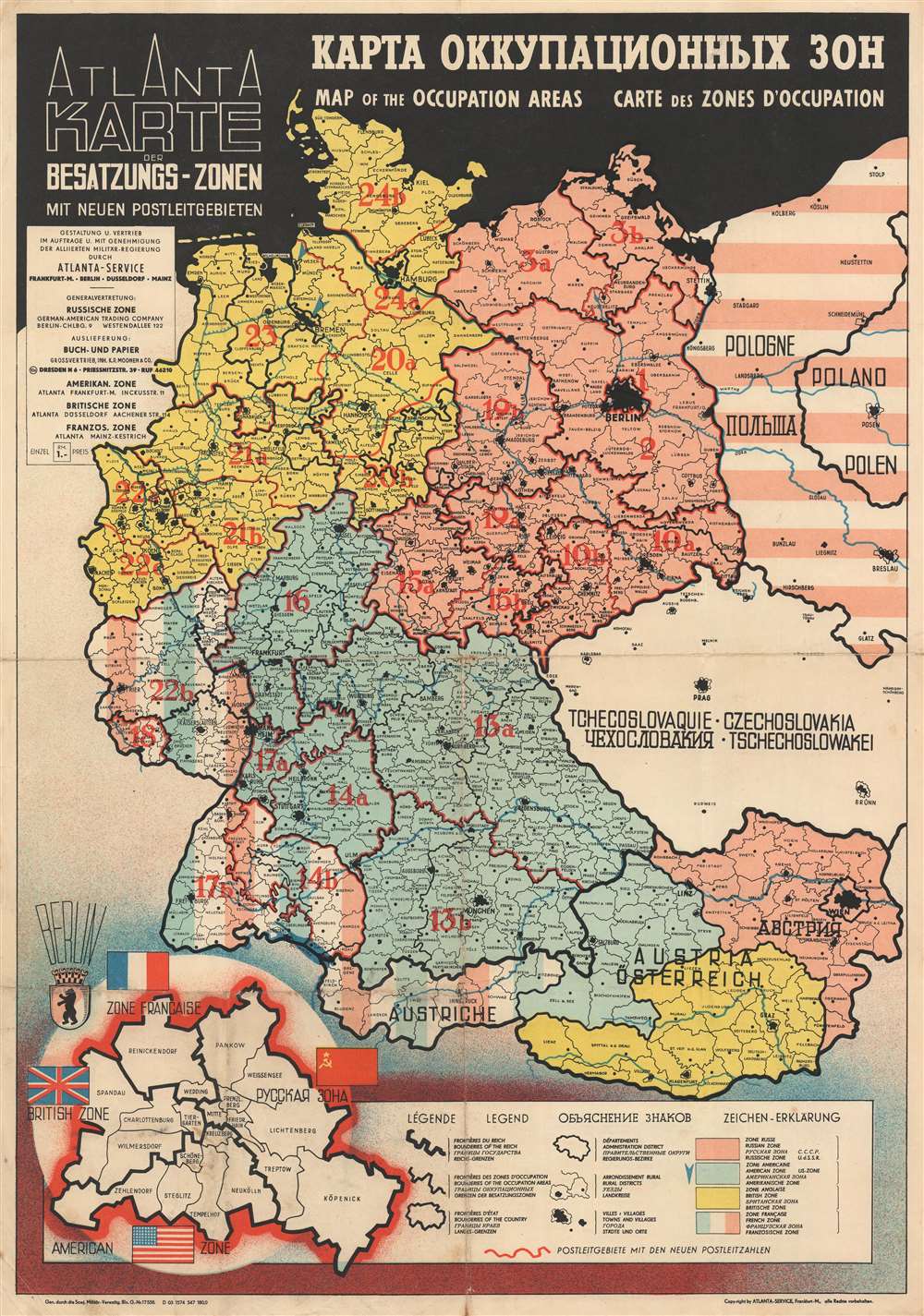
Atlanta Karte der Besatzungs-Zonen mit Neuen Postleitgebieten. КАРТА ОККУПАЦИОННЫХ ЗОН. Map of the Occupation Areas. Carte des Zonesd'Occupation.
1946 (undated) 23 x 16 in (58.42 x 40.64 cm) 1 : 2200000
1946 (undated) 23 x 16 in (58.42 x 40.64 cm) 1 : 2200000
Description
This is the c. 1946 Atlanta Service map of Germany delineating the Allied Occupation Zones after the defeat of Nazi Germany. Text appears in four different languages: English, Russian, French, and German. The Oder-Neisse Line, the basis for the border between Germany and Poland, is in bold. The four Occupation Zones, administered by the United States, Great Britain, France, and the Soviet Union, are divided and shaded accordingly. Former Eastern Germany is highlighted to indicate that it was now part of a reconstituted Poland, and possibly its allegiance to the Soviet Union. Berlin is specifically highlighted, because, as it was the capital of defeated Nazi Germany, it was decided that all four Allies would occupy and administer a sector of the city. An inset in the lower-left depicts a divided Berlin, illustrating neighborhoods within each zone.
The Allied Occupation of Germany
The United States, Great Britain, and the Soviet Union agreed to divide conquered Germany into zones of occupation at the February 1945 Yalta Conference. The more comprehensive plan to create four separate zones was ratified at the subsequent Potsdam Conference. Unfortunately, the cordiality between the Western Allies and the Soviet Union began evaporating soon after the war, and by 1947 any effort to govern Germany jointly floundered. The British and American zones merged on January 1, 1947, creating the jointly administered 'Bizone'. This entity was soon joined by the French zone, necessitating a name change to 'Trizone'. In May 1949, these zones merged to form the Federal Republic of Germany (West Germany). In October 1949, the Soviets established the German Democratic Republic (East Germany). The occupation in West Germany continued until May 5, 1955, when the General Treaty transferred governance from the Allied military governments to civilian German leaders. Soviet East Germany remained until 1990.Publication History and Census
This map was created by Atlanta Service and published c. 1946. Three different editions were published, the main difference being language, either Russian, English, or French, was printed along the top border in larger lettering. Since the title of this map varies in order only, it is extremely difficult to know which edition is held in which institutional collection. The OCLC catalogs at least two examples of the present edition, which are part of the collections at the German National Library in Leipzig and the Sächsische Landesbibliothek - Staats - und Universitätsbibliothek in Dresden. Another example is part of the David Rumsey Map Collection.Cartographer
Atlanta Service (fl. c. 1945 - 1947), also known as Atlanta GmbH, was a 'company for international advertising for industry, export, and traffic' operating in Frankfurt am Main in the years just after World War II. More by this mapmaker...
Condition
Very good. Exhibits light wear along original fold lines. Verso repairs include closed margin tear and reinforcement to minor fold separations.
References
Rumsey 11424.000. OCLC 723830075.