This item has been sold, but you can get on the Waitlist to be notified if another example becomes available, or purchase a digital scan.
1945 Atlanta GmbH Map of Germany and Allied Occupation Zones After World War II
OccupiedGermany-atlantamap-1945$200.00

Title
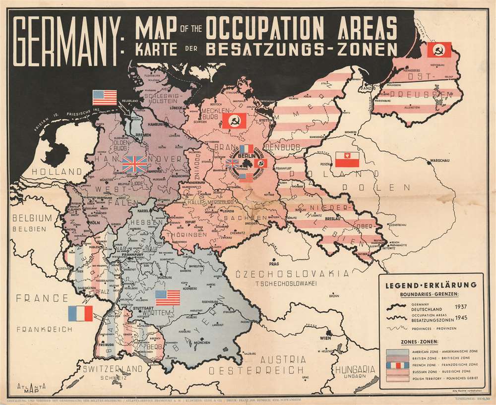
Germany: Map of the Occupied Areas. Karte der Besatzungs-Zonen.
1945 (undated) 16.75 x 20.5 in (42.545 x 52.07 cm) 1 : 2700000
1945 (undated) 16.75 x 20.5 in (42.545 x 52.07 cm) 1 : 2700000
Description
This is a bilingual English and German 1945 World War II (WWII) Atlanta Service map of Germany delineating the Allied Occupation Zones after the defeat of Nazi Germany. Germany follows its 1937 borders. The Oder-Neisse Line, the basis for the border between Germany and Poland, is in bold. The four Occupation Zones, administered by the United States, Great Britain, France, and the Soviet Union, are divided and shaded accordingly to allow for easy differentiation. What was formerly Eastern Germany is shaded using red and white stripes to indicate that it was now part of a reconstituted Poland. Berlin is specifically highlighted, because, as it was the capital of defeated Nazi Germany, it was decided that all four Allies would occupy and administer a sector of the city.
The Allied Occupation of Germany
The United States, Great Britain, and the Soviet Union first agreed to divide a conquered Germany into zones of occupation at the February 1945 Yalta Conference, and the plan to create four zones of occupation was ratified at the subsequent Potsdam Conference. Unfortunately, the cordiality between the Western Allies and the Soviet Union began evaporating soon after the end of the war, and by 1947 any effort to govern Germany jointly floundered. The British and American zones merged on January 1, 1947, creating the jointly administered 'Bizone'. This entity was soon joined by the French zone, necessitating a name change to 'Trizone'. These three zones merged to form the Federal Republic of Germany (West Germany) in May 1949. In October 1949, the Soviets established the German Democratic Republic (East Germany). The occupation in West Germany continued until May 5, 1955, when the General Treaty, which transferred governance from the Allied military governments to civilian German leaders, went into effect.Publication History and Census
This map was created by Atlanta Service and published in 1945. We have located one institutional example, which is part of the Harry W. Mazal Holocaust Collection at the University of Colorado Boulder and it appears on the private market sporadically.Cartographer
Atlanta Service (fl. c. 1945 - 1947), also known as Atlanta GmbH, was a 'company for international advertising for industry, export, and traffic' operating in Frankfurt am Main in the years just after World War II. More by this mapmaker...
Condition
Good. Exhibits soiling. Wear along original fold lines. Area of infill at fold intersection. Blank on verso.