This item has been sold, but you can get on the Waitlist to be notified if another example becomes available, or purchase a digital scan.
1915 Hyde Map of Ocean Beach and Ocean Bay Park, Fire Island
OceanBeach-hyde-1915$175.00

Title
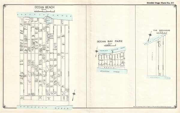
Ocean Beach. / Ocean Bay Park. / The Breakers.
1915 (dated) 16 x 25.75 in (40.64 x 65.405 cm)
1915 (dated) 16 x 25.75 in (40.64 x 65.405 cm)
Description
This is a 1915 E. Belcher Hyde set of three maps of communities located on Fire Island, New York, printed on one sheet, depicting Ocean Beach, Ocean Bay Park, and The Breakers in their entirety. Each community is presented in detail, with the community's streets and the residences of its citizens illustrated and labeled. Ocean Beach is by far the largest of the three, and, intriguingly, all of its streets are labeled as 'walks' and not as 'streets' or 'avenues'. Very few buildings in Ocean Beach are not homes; the New Surf Hotel, the Water Tower, the store, and the post office are among these establishments. In Ocean Bay Park, numerous streets are illustrated, but only about a half dozen homes are labeled. The U.S. Coast Guard Life Saving Station located in the community is illustrated as well. By far the smallest of the three communities is The Breakers, consisting of two roadways and four plots of land that are owned by individuals. No other detail is included.
This map was created and published by the E. Belcher Hyde Company of Brooklyn, New York in 1915.
This map was created and published by the E. Belcher Hyde Company of Brooklyn, New York in 1915.
Cartographer
Hyde and Company (fl. c. 1880 - 1920) (a.k.a. E. Belcher Hyde Map Company) was a Brooklyn, New York, publisher of maps and atlases. Hyde's work primarily focused on Long Island and the fire insurance industry, which required highly detailed maps of cities and towns in order to assess risk and liability. Many of Hyde's maps offered incredible detail at a large scale, including annotations on property owners, building materials, size, and function. While Long Island was the focus of most of the firm's efforts, it also produced atlases of the greater New York City metropolitan area, including the Bronx, Queens, Manhattan, and Westchester. More by this mapmaker...
Condition
Very good. Verso repair to centerfold separation. Blank on verso.