1866 Rand McNally Map of Australia and Polynesia
Oceanica-mcnally-1866$75.00

Title
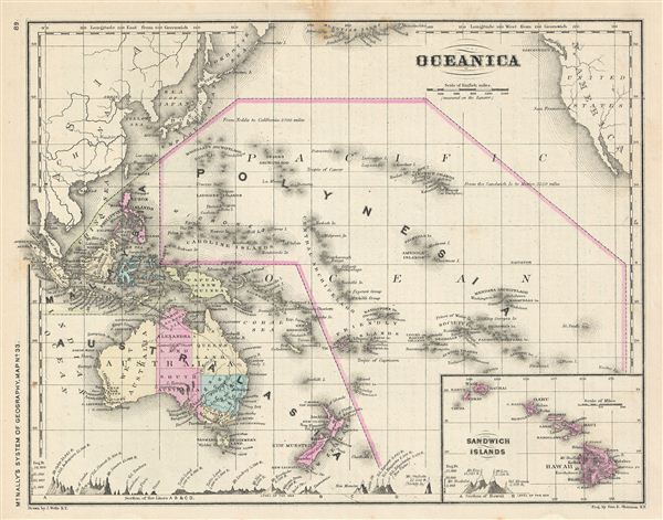
Oceanica.
1866 (undated) 9 x 11.5 in (22.86 x 29.21 cm)
1866 (undated) 9 x 11.5 in (22.86 x 29.21 cm)
Description
This is a beautiful example of Francis McNally's 1866 map of 'Oceanica' or the Pacific Ocean, including Australia and Polynesia. Covers the region in considerable detail with parts of North America and Asia included. extends as far north as the Aleutian Islands and as far south as New Zealand. Inset in the lower right quadrant depicts the Sandwich or Hawaiian Islands. This map depicts the continent of Australia with good detail along the coast and a largely unexplored interior. Various cities, towns, rivers and an assortment of additional topographical details are identified. Map is color coded according to political boundaries with elevation rendered by hachure. This map was issued as map no. 33 in McNally's System of Geography.
Cartographer
Rand, McNally and Co. (fl. 1856 - present) is an American publisher of maps, atlases and globes. The company was founded in 1856 when William H. Rand, a native of Quincy, Massachusetts, opened a print shop in Chicago. Rand hired the recent Irish immigrant Andrew McNally to assist in the shop giving him a wage of 9 USD per week. The duo landed several important contracts, including the Tribune's (later renamed the Chicago Tribune) printing operation. In 1872, Rand McNally produced its first map, a railroad guide, using a new cost effective printing technique known as wax process engraving. As Chicago developed as a railway hub, the Rand firm, now incorporated as Rand McNally, began producing a wide array of railroad maps and guides. Over time, the firm expanded into atlases, globes, educational material, and general literature. By embracing the wax engraving process, Rand McNally was able to dominate the map and atlas market, pushing more traditional American lithographic publishers like Colton, Johnson, and Mitchell out of business. Eventually Rand McNally opened an annex office in New York City headed by Caleb S. Hammond, whose name is today synonymous with maps and atlases, and who later started his own map company, C. S. Hammond & Co. Both firms remain in business. More by this mapmaker...
Source
McNally, F., An Improved System of Geography, 1866.
Condition
Very good. Text on verso.