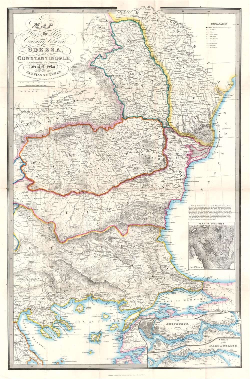
1854 Wyld Map of the Eastern Balkans and Black Sea During the Crimean War
OdessaConstantinople-wyld-1854$850.00


Title
Map of the Country between Odessa and Constantinople, embracing the Present Seat of War between the Russians and Turks.
1854 (undated) 31.75 x 20.75 in (80.645 x 52.705 cm) 1 : 1400000
1854 (undated) 31.75 x 20.75 in (80.645 x 52.705 cm) 1 : 1400000
Description
This is an 1854 James Wyld map of the eastern Balkans and the Black Sea coast during the Crimean War. The map depicts the region from Salonica to Odessa, and from the Dnister (Dniester) River to the island of Lesbos (I. Mytilini) in the Aegean Sea. Published in the middle of the conflict, Wyld presents the theater of war, highlighting the two regions first occupied by the Russian Empire (Wallachia and Moldavia) and allowing his viewers a better understanding of the news they were receiving from their armies in the Balkans.
Geographic Context
Highly detailed, myriad cities, towns, and villages are labeled throughout, including Odessa, Adrianople, Salonica, Gallipoli, and Constantinople. Topography is also noted, with chains of hills and mountains indicated by hachure and rivers and streams meandering their way to the sea. Three different grades of roads are marked from 'great roads' to 'carriage roads' and finally to 'cross roads'. Ancient roads are also noted. Forts and batteries, Greek monasteries, and inns are also marked. Various colors are used to highlight regional boundaries, with Moldavia, Austria, Bessarabia, Walachia, Bulgaria, and Rumili among those identified. A brilliant blue sets apart the regional seas, as well as the Bosporus (Bosphorus) and the Strait of the Dardanelles in two inset maps situated in the lower right corner. A plan of the town of Schoumla is situated along the right border. This city, located along two mountain passes through the Balkan Mountains, was an important site in the Crimean War, which was raging at the time of this map's publication. Per the map, only five practicable passes over the Balkan Mountains existed at this time, and the two routes through Schoumla led directly to Constantinople, the capital of the Ottoman Empire.The Crimean War
The Crimean War, with an alliance of the Ottoman Empire, Britain, France, and Sardinia on one side of the conflict and the Russian Empire on the other, lasted from October 1853 until February 1856. The root cause of the war has never been fully understood, but the stated impetus for hostilities was the rights of Christians in the Holy Land, with the Catholics being supported by the French and the Greek Orthodox Church gaining the support of the Russians. Other factors also included the gradual decline of the Ottoman Empire and British and French concerns about Russian gains in the region at the cost of the Ottomans.Further Historical Context
Hostilities erupted in July 1853 when Russia invaded two Ottoman suzerainties known collectively as the Danubian Principalities, labeled here as Wallachia and Moldavia. The Ottomans immediately responded and fought a defensive campaign that eventually halted the Russian advance at Silistra, which the Russians besieged. Alarmed by the possibility of an Ottoman collapse, the British and French jumped to their aid, sending troops and supplies to Gallipoli. They did not arrive at Silistra until after the Russians had withdrawn.Further Conflict
Now, public opinion at home, where discontent at the seemingly wasted effort and expense of sending armies to the Balkans, exerted an influence on the alliance. This outcry led to the planning and execution of an invasion of the Crimean Peninsula in September and a siege of the Russian naval port of Sevastopol, their primary naval base in the Black Sea, which lasted for eleven months. Russia finally sued for peace in March 1856 and in the Treaty of Paris the ended the war Russia lost its Black Sea ports, Wallachia and Moldavia gained a modicum of independence, and Christians in the Holy Land were given a degree of equality.Publication History and Census
This map was created and published by James Wyld in 1854. The OCLC records examples as being part of the collections at Yale University, Harvard University, and the British Library.Cartographer
Wyld (1823 - 1893) was a British publishing firm active throughout the 19th century. It was operated by James Wyld I (1790 - 1836) and his son James Wyld II (November 20, 1812 - 1887) were the principles of an English mapmaking dynasty active in London during much of the 19th century. The elder Wyld was a map publisher under William Faden (1749 - 1836) and did considerable work on the Ordinance Survey. On Faden's retirement in 1823, Wyld took over Faden's workshop, acquiring many of his plates. Wyld's work can often be distinguished from his son's maps through his imprint, which he signed as 'Successor to Faden'. Following in his father's footsteps, the younger Wyld joined the Royal Geographical Society in 1830 at the tender age of 18. When his father died in 1836, James Wyld II was prepared to fully take over and expand his father's considerable cartographic enterprise. Like his father and Faden, Wyld II held the title of official Geographer to the Crown, in this case, Queen Victoria. In 1852, he moved operations from William Faden's old office at Charing Cross East (1837 - 1852) to a new, larger space at 475 Strand. Wyld II also chose to remove Faden's name from all of his updated map plates. Wyld II continued to update and republish both his father's work and the work of William Faden well into the late 1880s. One of Wyld's most eccentric and notable achievements is his 1851 construction of a globe 19 meters (60 feet) in diameter in the heart of Leicester Square, London. In the 1840s, Wyld also embarked upon a political career, being elected to parliament in 1847 and again in 1857. He died in 1887 following a prolific and distinguished career. After Wyld II's death, the family business was briefly taken over by James John Cooper Wyld (1844 - 1907), his son, who ran it from 1887 to 1893 before selling the business to Edward Stanford. All three Wylds are notable for producing, in addition to their atlas maps, short-run maps expounding upon important historical events - illustrating history as it was happening - among them are maps related to the California Gold Rush, the New South Wales Gold Rush, the Scramble for Africa, the Oregon Question, and more. More by this mapmaker...
Condition
Very good. Mounted on linen. Light wear and toning along original fold lines. Blank on verso.
References
OCLC 948645527.