This item has been sold, but you can get on the Waitlist to be notified if another example becomes available, or purchase a digital scan.
1839 Mitchell Pocket Map of Ohio, Indiana, Illinois and Michigan
OHINILMI-mitchell-1839$400.00

Title
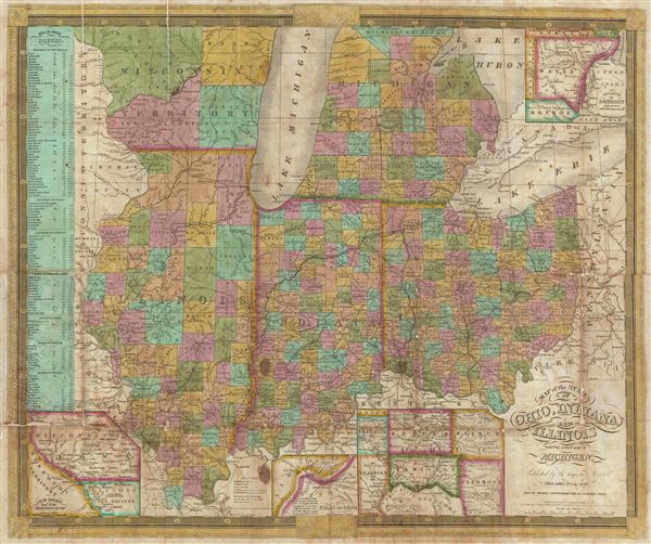
Map of the States of Ohio, Indiana, and Illinois with the settled par of Michigan.
1838 (dated) 18 x 22 in (45.72 x 55.88 cm)
1838 (dated) 18 x 22 in (45.72 x 55.88 cm)
Description
A scarce 1839 S. A. Mitchell pocket map depicting the states of Ohio, Indiana, Illinois, and Michigan. Insets include, 'Vicinity of Detroit,' 'Vicinity of Cincinnati,' 'Falls of Ohio,' 'Lead Region East of the Mississippi.' A chart on the left-hand side of the map details steamboat routes from: Pittsburg to New Orleans, Louisville to St. Louis, Louisville to Lafayette, St. Louis to Prairie du Chien, St. Louis to Peoria, Buffalo to Detroit, Detroit to Chicago. Dated and copyrighted 'Entered according to Act of Congress in the year 1834 by S. Augustus Mitchell in the Clerk's office of the district court of the eastern district of Pennsylvania.'
Cartographer
Samuel Augustus Mitchell (March 20, 1792 - December 20, 1868) began his map publishing career in the early 1830s. Mitchell was born in Bristol, Connecticut. He relocated to Philadelphia in 1821. Having worked as a school teacher and a geographical writer, Mitchell was frustrated with the low quality and inaccuracy of school texts of the period. His first maps were an attempt to rectify this problem. In the next 20 years Mitchell would become the most prominent American map publisher of the mid-19th century. Mitchell worked with prominent engravers J. H. Young, H. S. Tanner, and H. N. Burroughs before attaining the full copyright on his maps in 1847. In 1849 Mitchell either partnered with or sold his plates to Thomas, Cowperthwait and Company who continued to publish the Mitchell's Universal Atlas. By about 1856 most of the Mitchell plates and copyrights were acquired by Charles Desilver who continued to publish the maps, many with modified borders and color schemes, until Mitchell's son, Samuel Augustus Mitchell Junior, entered the picture. In 1859, S.A. Mitchell Jr. purchased most of the plates back from Desilver and introduced his own floral motif border. From 1860 on, he published his own editions of the New General Atlas. The younger Mitchell became as prominent as his father, publishing maps and atlases until 1887, when most of the copyrights were again sold and the Mitchell firm closed its doors for the final time. More by this mapmaker...
Condition
Good condition. Professionally flattened and backed with archival tissue. Removed from but sold with original binder.
References
Karpinski, Maps of Michigan, 126