1846 Burrows - Mitchell Map of Ohio
OhioCanals-mitchell-1846$360.00

Title
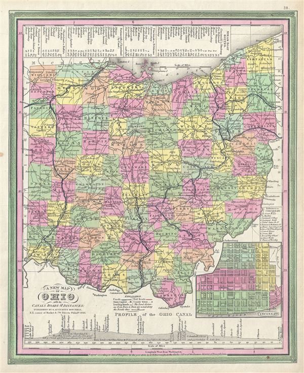
A New Map Of Ohio with its Canals Roads And Distances.
1846 (dated) 14.5 x 12 in (36.83 x 30.48 cm) 1 : 1400000
1846 (dated) 14.5 x 12 in (36.83 x 30.48 cm) 1 : 1400000
Description
This scarce hand colored map is a lithographic engraving of Ohio dating to 1846 by the legendary American Mapmaker S.A. Mitchell, the elder. Includes a detailed inset map of Cincinnati. Along the bottom there is a profile of the Ohio Canal with navigational notes. This is a rare transitional map produced by the mysterious engraver H. N. Burroughs, whose work for the Mitchell firm appears in 1846 between that of H.S. Tanner and Mitchell himself. Ristow notes, 'Nothing is known about Burroughs, but he was undoubtedly an employee or associate of Mitchell.' His fine and detailed work appears only in the hard to find 1846 edition of the Mitchell's Atlas. Entered according to Act of Congress in the year 1846, by H. N. Burrows in the Clerks Office of the Eastern District of Pennsylvania.
Cartographer
Samuel Augustus Mitchell (March 20, 1792 - December 20, 1868) began his map publishing career in the early 1830s. Mitchell was born in Bristol, Connecticut. He relocated to Philadelphia in 1821. Having worked as a school teacher and a geographical writer, Mitchell was frustrated with the low quality and inaccuracy of school texts of the period. His first maps were an attempt to rectify this problem. In the next 20 years Mitchell would become the most prominent American map publisher of the mid-19th century. Mitchell worked with prominent engravers J. H. Young, H. S. Tanner, and H. N. Burroughs before attaining the full copyright on his maps in 1847. In 1849 Mitchell either partnered with or sold his plates to Thomas, Cowperthwait and Company who continued to publish the Mitchell's Universal Atlas. By about 1856 most of the Mitchell plates and copyrights were acquired by Charles Desilver who continued to publish the maps, many with modified borders and color schemes, until Mitchell's son, Samuel Augustus Mitchell Junior, entered the picture. In 1859, S.A. Mitchell Jr. purchased most of the plates back from Desilver and introduced his own floral motif border. From 1860 on, he published his own editions of the New General Atlas. The younger Mitchell became as prominent as his father, publishing maps and atlases until 1887, when most of the copyrights were again sold and the Mitchell firm closed its doors for the final time. More by this mapmaker...
Source
Mitchell, S., A New Universal Atlas Containing Maps of the various Empires, Kingdoms, States and Republics Of The World, 1846.
Condition
Very good. Minor overall toning. Blank on verso.
References
Rumsey 0537.029. Philips (Atlases) 6103.