This item has been sold, but you can get on the Waitlist to be notified if another example becomes available, or purchase a digital scan.
1861 Mitchell Map of Ohio and Indiana
OhioIndiana-mitchell-1861$62.50

Title
County Map of Ohio, and Indiana.
1860 (dated) 11 x 14 in (27.94 x 35.56 cm) 1 : 2300000
1860 (dated) 11 x 14 in (27.94 x 35.56 cm) 1 : 2300000
Description
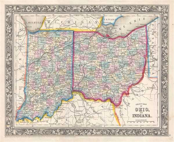
This is an 1861 Samuel Augustus Mitchell, Jr. map of Ohio and Indiana. The map depicts the region from Illinois to Pennsylvania and Virginia and from Lake Michigan, the State of Michigan, and Lake Erie to Kentucky and Virginia.
The Wabash and Erie Canal and the Miami and Erie Canal
Perhaps the most important aspect of this map is the illustration of the Wabash and Erie Canal, which connected the Great Lakes to the Ohio River. By establishing this link, a direct waterway from the Great Lakes to the Gulf of Mexico was created. Although the canal was known as the Wabash and Erie (that label does not appear here), it was actually a combination of four canals: the Miami and Erie Canal from Toledo, Ohio to Junction Ohio, the original Wabash and Erie Canal from Junction, Ohio to Terre Haute, Indiana, the Cross Cut Canal from Terre Haute, Indiana to Worthington, Indiana, and the Central Canal from Worthington, Indiana to Evansville Indiana. At over 460 miles long, the Wabash and Erie Canal was the longest canal constructed in North America. The Miami and Erie Canal, which also connected Lake Erie and the Ohio River, cut south across the state from Defiance, Ohio to Cincinnati, Ohio. Both canals, unfortunately, did not have the longest lifespan, because they soon were competing against railroads for customers, and rail was a much faster mode of transportation. The canals operated until the early 1900s, and then ceased operations due to a sharp decline in use and high operating costs.
Individual counties are illustrated, labeled, and shaded different colors to allow for easy differentiation in both Indiana and Ohio. Cities, such as Toledo, Cleveland, Cincinnati, Columbus, Indianapolis, Terre Haute, and Evansville are labeled, along with myriad other towns and villages. Rivers, creeks, and lakes are illustrated as well, though not all are labeled.
This map was prepared by S. A. Mitchell Jr. for inclusion in the 1861 edition of Mitchell's New General Atlas. Like many American map publishers of this period, Mitchell did not regularly update his copyrights, consequently this map is dated and copyrighted to 1860: 'Entered according to Act of Congress in the Year 1860 by S. Augustus Mitchell Jr. in the Clerk's Office of the District Court of the U.S. for the Eastern District of Pennsylvania.'
Cartographer
Samuel Augustus Mitchell (March 20, 1792 - December 20, 1868) began his map publishing career in the early 1830s. Mitchell was born in Bristol, Connecticut. He relocated to Philadelphia in 1821. Having worked as a school teacher and a geographical writer, Mitchell was frustrated with the low quality and inaccuracy of school texts of the period. His first maps were an attempt to rectify this problem. In the next 20 years Mitchell would become the most prominent American map publisher of the mid-19th century. Mitchell worked with prominent engravers J. H. Young, H. S. Tanner, and H. N. Burroughs before attaining the full copyright on his maps in 1847. In 1849 Mitchell either partnered with or sold his plates to Thomas, Cowperthwait and Company who continued to publish the Mitchell's Universal Atlas. By about 1856 most of the Mitchell plates and copyrights were acquired by Charles Desilver who continued to publish the maps, many with modified borders and color schemes, until Mitchell's son, Samuel Augustus Mitchell Junior, entered the picture. In 1859, S.A. Mitchell Jr. purchased most of the plates back from Desilver and introduced his own floral motif border. From 1860 on, he published his own editions of the New General Atlas. The younger Mitchell became as prominent as his father, publishing maps and atlases until 1887, when most of the copyrights were again sold and the Mitchell firm closed its doors for the final time. More by this mapmaker...
Source
Mitchell, S. A., Mitchell's New General Atlas Containing Maps of the Various Countries of the World, Plans of Cities, Etc., embraced in Forty-Seven Quarto Maps, Forming a series of Seventy-Six Maps and Plans, together with Valuable Statistical Tables (Philadelphia: S. Augustus Mitchell, Jr.) 1861.
Mitchell's New General Atlas was published by Samuel Augustus Mitchell, Jr., the son of the prolific cartographer Samuel Augustus Mitchell. Many of the plates are derived from the his father's Mitchell's Universal Atlas, but not directly. The Mitchell's Universal Atlas was initially sold to Thomas, Cowperthwait, and Company in 1849, and again to Charles Deliver in 1856. It was Deliver who introduced the new vibrant color scheme, abandoning the older Mitchell's Universal Atlas green borders and themes for bright reds, blues, and yellows. Samuel Augustus Mitchell, Jr. acquired the Deliver plates in 1859. He added his own floral motif border, but doubled down on the vibrant color scheme, thus introducing to the American public the most vividly colored American atlas of the 19th century. In 1860, he published the first edition of his New General Atlas and, despite a slump in sales during the American Civil War, attained a level of success to rival his father. Mitchell would continue to publish the New General Atlas until 1887, when the firm formally closed.
Condition
Very good. Even overall toning. Blank on verso.
References
Rumsey 0565.021 (1860 edition).