1824 Tanner Map of Ohio and Indiana
OhioIndiana-tanner-1824$2,000.00

Title
Ohio and Indiana By H.S. Tanner.
1824 (dated) 21.25 x 26 in (53.975 x 66.04 cm) 1 : 1100000
1824 (dated) 21.25 x 26 in (53.975 x 66.04 cm) 1 : 1100000
Description
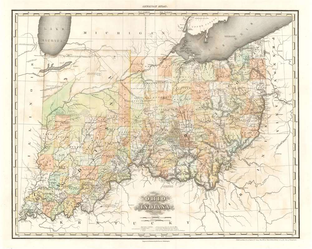
A rare and important map of Ohio and Indiana by Henry S. Tanner, in a transitional state between the 1823 and 1825 editions of his New American Atlas. This elephant folio map covers all of Ohio and Indiana in detail, as well as sketching in adjacent parts of Michigan, Illinois, Kentucky, Virginia and Pennsylvania. The map is a strong example of Tanner's superb engraving, showing rivers, topography by hachure, cities, towns and roadways.This section of the State contains much good land; but intersected with long, narrow, swamps, boggy and miry, the soil of which is a stiff blue clay. The 1824 map dispenses with this description, instead describing the land north of the Wabash:
A Transitional State
The copyright on this map, is May 24, 1819; this is the date found on this map in the later issues of 1825 and 1833 as well. This example appeared in an 1823 edition of the New American Atlas. The plate, nonetheless, differs sharply both from other 1823 and 1825 examples (compare with Rumsey's examples of these years), and contextual details suggest that this revised map was executed in 1824.Many Towns Noted, Corrected
Between the first issue of this map and this example, dozens of place names have been added: towns, villages, rivers, creeks and even individual farms appear on this map that are absent on the 1823 first state. (A few that appear on the 1823 are removed as well!)The Northwestern Counties of Ohio
Some of the most drastic changes in Ohio take place in the counties west of Sandusky Bay. Henry, Wood, Sandusky, Seneca, Crawford and Marion counties are shown on the 1823 as marshy and uninviting; here the swamplands are expunged. Fort Stephenson - the site of a rare American victory in the war of 1812 - has also been added. These counties were largely the result of February 1820 treaties and purchases from Native American tribes, notably the Wyandot Nation. Mercer County on the earlier state marks the presence of 'Miami Indians' and includes a note thatDuring the spring floods, canoes pass from the Miami to the Wabash and thence into Maumee River.On the updated state of the map, these references are removed. Mercer county itself would not officially exist until January 1824, so it is likely that this map dates to 1824 despite its older copyright.
The Cession of Indiana
The sharpest distinctions between the first state of this map, and this example is the explosion of European settlement in Indiana. The 1823 issue of this map explicitly refers to the 1818 'Delaware's Cession,' or the Treaty of St. Mary's. Actually six separate treaties between the United States and nine Native American Nations (including the Delaware), The 'Delaware Cession' resulted (in the area covered by this map) in the cession of Wea Indian claims to all lands in Ohio, Indiana, and Illinois, the cession of Miami lands south of the Wabash, a tract consisting of the entire central portion of Indiana.Illustrating the Occupation of Indiana
The 1823 map still shows, in most of Indiana north of Franklin and Vigo counties, Native American territory with the tribal names of the Miamis, Kickapoo, Shawnee, and Pattawatima Nations. This 1824 state of the map marks an 'Indian Boundary' some twenty-five miles northwest of the Wabash River, with tribal names much fewer, and reduced in extent. Meanwhile, a dozen new counties have been formed south of the Wabash, pushing ever northwards. Even descriptions of the land have been changed: On the 1823, the land south of the Wabash is described thus:Country interspersed with small lakes which connect the waters of the Mississippi with those of the northern lakes.Not only does the map reveal the takeover of Indiana by Europeans, it actively provides encouraging detail for prospective settlers: an example of the map as a tool of occupation.
Legionville, PA
Across the border into Pennsylvania can be seen 'Legionville (in ruins)' - a feature not included in the 1823 Tanner map of Pennsylvania and New Jersey. Legionville was, between 1792 and 1795, the first formal basic training facility for the military of the United States, then represented by the Legion of the United States. This was America's first standing army composed of professional soldiers, as opposed to the state militias. Legionville's position near the Ohio border speaks to a history of defeats of American forces at the hands of the Native American Western Confederacy in 1790 and 1791. In 1824 the site was purchased by the Harmony Society for the establishment of their third settlement; by then the site had fallen into disuse and by 1819 was certainly 'in ruins.'Publication History and Census
The map was engraved by Tanner (and his assistants) for inclusion in an 1823 edition of his New American Atlas. It is rare: we see only one example of the 1823 edition of this separate map in the BnF; their copy is not digitized, and we are not aware if their example is of the original 1823 first state, or this transitional state. Four examples of the 'Improved to 1825' state appear in OCLC. Perhaps twenty-five examples of the 1823 New American Atlas are catalogued in OCLC.Cartographer
Henry Schenck Tanner (1786 - May 18, 1858) was one of the preeminent American map engravers and publishers of the early 19th century - what is considered to be the "Golden Age of American Map Publishing". Born in New York City but based in Philadelphia, Tanner's forty plus year career was almost entirely focused on cartographic work. His earliest map work appears in conjunction with another important map publisher, John Melish. Early in his career, Tanner partnered with his brother Benjamin, to engrave extensively for Melish as well as other Philadelphia publishers including Lucas Fielding (Baltimore), A. Bourne, Jason Torey, Samuel Harrison, and Samuel Lewis, among others. In 1818 Tanner convinced his fellow publishers and partners to finance the compilation of a New American Atlas. The atlas was sold by subscription and slowly emerged between 1819 and 1823. The New American Atlas, possibly the pinnacle of 19th century American cartography and was commended in its day as "one of the most splendid works of the kind ever executed in this country". It was subsequently republished in several updated editions until about 1839. Tanner had by this time become the most active and influential map publisher in the United States. Around 1832, recognizing the market for a less cost prohibitive atlas, Tanner began work on the smaller format New Universal Atlas. This popular and important atlas went through numerous editions before being bought out by Carey and Hart, and then, in 1846, by S. A. Mitchell, who would rise to become the preeminent publisher of the next generation. In addition to these important atlases, Tanner also issued numerous extremely important and influential travelers guides, state maps, wall maps, and pocket maps. He should not be confused with his brother, also an America map engraver, the New Yorker Benjamin Tanner. More by this mapmaker...
Source
Tanner, H. S., A New American Atlas, (Philadelphia: Tanner) 1823.
Condition
Good condition. Mended centerfold split with virtually no loss.
References
Compare Rumsey 5388.018 (1823). Phillips (Atlases) P4463.