This item has been sold, but you can get on the Waitlist to be notified if another example becomes available, or purchase a digital scan.
1952 Javier Cyanotype Map of Okinawa, Japan
OkinawaRecreationalMap-javier-1952$475.00


Title
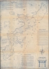
Okinawa Recreational Map. The 'Garden Spot of the Pacific'.
1952 (dated) 41.25 x 30 in (104.775 x 76.2 cm) 1 : 100000
1952 (dated) 41.25 x 30 in (104.775 x 76.2 cm) 1 : 100000
Description
This is a rare reverse cyanotype 1952 F.C. Javier 'recreation' map of Okinawa, Japan, likely created for members of the Twentieth Air Force and their families. The map depicts the entire island along with several smaller islands off its coast with 'Points of interest' identified. Among these are sites relevant to World War II (1939 - 1945), including the memorial to war correspondent Ernie Pyle (1900 - 1945), who was killed on Ie Shima (Iejima) during the Battle of Okinawa. Other sites include Buddhist temples and shrines, castles, and the International Cemetery. Short explanations of many sites appear here and there on the map. Dependent housing, beaches, and the Headquarters of the Twentieth Air Force are prominently labeled. Pictorial elements, such as fish, birds, and lizards, add an artistic flair to the piece.
The Twentieth Air Force
The Twentieth Air Force was established on April 4, 1944, and was deployed to the World War II Pacific Theater. Initially, the Twentieth operated out of bases in India, staged through bases in China, and bombed the Japanese Home Islands. The Twentieth moved to the Mariana Islands in the Northern Pacific Ocean in late 1944. Parts of the Twentieth Air Force moved to Okinawa in 1949 and was assigned to Kadena Air Base. The Twentieth Air Force was based on Okinawa and in the Marianas in the 1950s. It inactivated on March 1, 1955 and reactivated on September 1, 1991, as part of Strategic Air Command.Cyanotype: Why so Blue?
Cyanotype is a photo-reprographic technique developed in 1842 by the British astronomer John Herschel (1792 - 1871). Sometimes called a 'sunprint', the technique employs a solution of ferric ammonium citrate and potassium ferricyanide, which painted on white paper or cloth, reacts when exposed to sunlight to dye the object a brilliant blue. Areas blocked from ultraviolet exposure remain undyed and white. Herschel developed the technique to reproduce his astronomical notes, but others quickly realized that any object capable of blocking light could be used to quickly and easily create a cyanotype image. By the late 19th century, the process became popular with designers, military, architects, and engineers (blueprints), who used the cheap an effective technique to efficiently and exactly reproduce images in the field. Cyanotyping is limited in that only a single copy can be made at one time, so it was only practical for short-term field work. It is also of note that cyanotypes remain extremely reactive to light and, over time, fade or degrade, making them extremely ephemeral. The process fell out of fashion in most places by the 1920s, but remains in use in some parts of the world, such as India and Nepal, to this day.Publication History and Census
This map was drawn and traced by F.C. Javier and published by the Office of the Director of Communications of the Headquarters of the Twentieth Air Force on November 25, 1952. This is the only known surviving example.Condition
Very good. Cyanotype. Closed margin tears professionally repaired on verso.