This item has been sold, but you can get on the Waitlist to be notified if another example becomes available, or purchase a digital scan.
1945 Sundberg 'Old Man River' Map of the Mississippi
OldManRiver-sundberg-1945$225.00

Title
Ole Man River.
1945 (dated) 14.5 x 21 in (36.83 x 53.34 cm) 1 : 7000000
1945 (dated) 14.5 x 21 in (36.83 x 53.34 cm) 1 : 7000000
Description
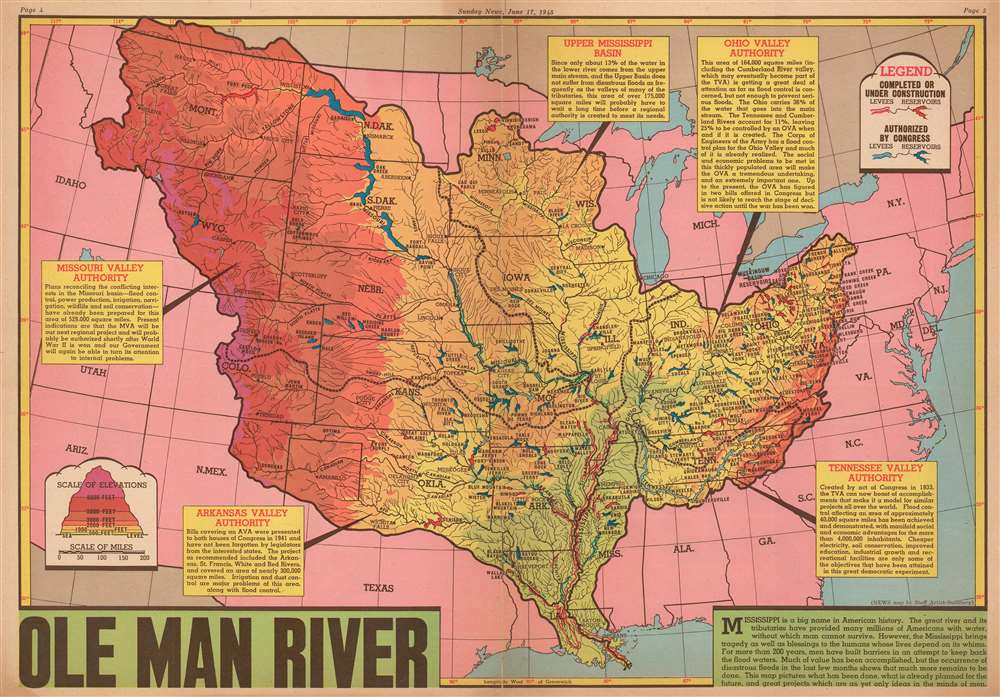
This is a 1945 Edwin L Sundberg map of the Mississippi River System in the United States. The map depicts the region from Nevada and Idaho to the Atlantic Ocean and from Canada to Texas and the Gulf of Mexico. After the region suffered one of its worst floods in recorded history, attention was focused on measures being taken to prevent such disasters. Red and blue notations on the map highlight levees and reservoirs used in flood control, with red levees and reservoirs representing projects that had been completed or were currently under construction and blue ones noting future projects that had already been approved by Congress. This vast undertaking not only prevented citizens from losing their homes to floodwaters, but also held numerous other benefits, such as 'power production, irrigation, navigation, and wildlife and soil conservation' in the Missouri Valley. Similar projects in the Arkansas Valley were meant to help with irrigation and dust control. Each reservoir, no matter whether it was completed or proposed, is identified by name. Shading is used to illustrate the changes in elevation throughout the system, which provides a much broader image for the reader. Text boxes about the Missouri Valley Authority, the Arkansas Valley Authority, the Tennessee Valley Authority, the Ohio Valley Authority, and the Upper Mississippi Basin contain information about each authority.
Publication History and Census
This map was created by Edwin Sundberg and published by the Sunday News on June 17, 1945. Even though Sundberg's works were produced for a New York City newspaper, his maps vary in scarcity today. We have been unable to locate any known examples in institutional collections and have been able to locate only one other instance when it has appeared on the private market.Cartographer
Edwin L. Sundberg (1898 - 1978) was an American cartographer known for his pictorial pieces. Sundberg was a staff artist for the Sunday News in New York City and eventually became Chief Cartographer in charge of a small staff of artists. More by this mapmaker...
Condition
Very good. Newsprint. Closed margin tears professionally repaired on verso. Verso repairs to centerfold separations. Text and printed photographs on verso.