This item has been sold, but you can get on the Waitlist to be notified if another example becomes available, or purchase a digital scan.
1892 Rand McNally Map of Ontario, Canada
Ontario-randmcnally-1892$37.50

Title
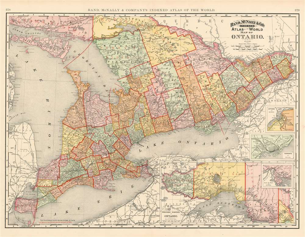
Map of Ontario.
1892 (dated) 20 x 27 in (50.8 x 68.58 cm) 1 : 1130000
1892 (dated) 20 x 27 in (50.8 x 68.58 cm) 1 : 1130000
Description
This is a beautiful example of Rand McNally and Company's 1892 map of Ontario, Canada. Centered on Lake Ontario, the map covers Upper or West Canada from Essex to Prescott. Four inset maps in the lower right quadrant detail the western portion of Ontario, River St. Mary, Toronto and Ottawa. Both the electoral counties and the municipal counties are identified and labeled in black and red respectively. All five of the Great Lakes are illustrated. Although the region suffered economically during the recession of 1893, Ontario continued to flourish in mineral exploitation and industry. Color coded according to political boundaries, the map notes several towns, cities, rivers and various other topographical details with relief shown by hachure.
Publication History
This map was issued as plate nos. 378 and 379 in Rand McNally and Company's Indexed Atlas of the World, possibly the finest atlas Rand McNally ever issued.Cartographer
Rand, McNally and Co. (fl. 1856 - present) is an American publisher of maps, atlases and globes. The company was founded in 1856 when William H. Rand, a native of Quincy, Massachusetts, opened a print shop in Chicago. Rand hired the recent Irish immigrant Andrew McNally to assist in the shop giving him a wage of 9 USD per week. The duo landed several important contracts, including the Tribune's (later renamed the Chicago Tribune) printing operation. In 1872, Rand McNally produced its first map, a railroad guide, using a new cost effective printing technique known as wax process engraving. As Chicago developed as a railway hub, the Rand firm, now incorporated as Rand McNally, began producing a wide array of railroad maps and guides. Over time, the firm expanded into atlases, globes, educational material, and general literature. By embracing the wax engraving process, Rand McNally was able to dominate the map and atlas market, pushing more traditional American lithographic publishers like Colton, Johnson, and Mitchell out of business. Eventually Rand McNally opened an annex office in New York City headed by Caleb S. Hammond, whose name is today synonymous with maps and atlases, and who later started his own map company, C. S. Hammond & Co. Both firms remain in business. More by this mapmaker...
Source
Rand McNally and Co., Foreign Countries. Rand, McNally and Co's Indexed Atlas of the World (Complete in Two Volumes)…, (Chicago) 1895.
Condition
Very good. Marginal mend to bottom centerfold outside image. Text on verso.
References
Rumsey 3565.060 (1897 edition). Philip (atlases) 1026 (1898 edition).