
1936 Orlando Chamber of Commerce City Plan or Map of Orlando, Florida

This item has been sold.
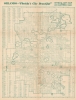
Orlando - 'Florida's City Beautiful'. Official City Map.
Orlando, after the boom years.
Choose a Collection:
- Digital Map Information
- Suitable for large format printing
- Full resolution TIFF file
- ICC color profile embedded
- Delivered instantly via download link
This Item
Enquire
Orlando, after the boom years.
A 1936 city plan or map of Orlando, Florida, published by the city's Chamber of Commerce. It was published after the collapse of the Florida Land Boom, which had completely transformed the city.A Closer Look
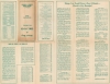
Coverage extends from Par Avenue south to Lake Wade, taking in today's central Orlando. An alphanumeric grid surrounds the map, providing coordinates to a street index at left. Aside from streets, rail lines (the Atlantic Coast Line and Seaboard Air Line), and lakes, local landmarks such as Greenwood Cemetery and the fairgrounds (where the Central Florida Fair is still held) are noted. Closely packed numbers set at intersections appear to indicate zoning blocks.The verso provides a wealth of information on the local economy, real estate agents, accommodations, attractions, churches, climate, transportation, leisure, and recreational activities. The emphasis on housing and tourism harkens to the city's boom years in the preceding decades, but the Chamber of Commerce faced an uphill task promoting business in the difficult economic environment of the 1930s.
Publication History and Census
This map was created for and published by the Orlando Chamber of Commerce in 1936. Small text on the title panel on the verso indicates that it was lithographed by an individual or company named Robinson. There are at least two states of this map: one (sold previously by us) includes red overprinting highlighting a 'twenty-three mile scenic drive,' Tinker Field, and other local landmarks, while on the present state the overprinting is absent. We note five examples of a map bearing this title cataloged in OCLC, which are part of the collections at Harvard University, Syracuse University, Pennsylvania State University, the University of Chicago, the State Library of Florida, and the Jacksonville Public Library. Unfortunately, none of these records include images of the cataloged map, so there is no way of knowing which state these examples represent. We also note an example of the present state without the red overprinting at the Touchton Map Library, Tampa Bay History Center.Condition
Good. Toning. Light wear along original fold lines. Text on verso.
References
Tampa Bay History Center, Touchton Map Library 2018.063.048. OCLC 43952383.