1839 Bradford Map of New York City
NewYorkCity-bradford-1839-3$450.00

Title
New York.
1839 (undated) 14 x 11.5 in (35.56 x 29.21 cm) 1 : 24000
1839 (undated) 14 x 11.5 in (35.56 x 29.21 cm) 1 : 24000
Description
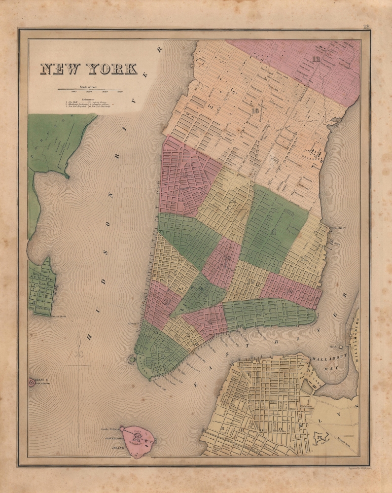
This is Thomas Bradford's important 1839 city plan or map of New York City produced for his Illustrated Atlas. It was a highly influential map, becoming a prototype for several important later maps of New York City by Tanner, Mitchell, and others.
A Closer Look
Coverage includes Manhattan from 53rd Street to the Battery, with parts of adjacent Brooklyn, Hoboken, and Jersey City. The whole is beautifully engraved in Boynton's delicate style, with important buildings, parks, streets, rail lines, and piers noted. The map predates landfill along the East River and on the Jersey side of the Hudson - though these areas are in fact ghosted in. Fort Green, the Navy Yard in Brooklyn, Fort Columbus on Governor's Island, Fort Gibson on Ellis Island, City Hall, Bellevue Hospital, the Public Cemetery, the Deaf and Dumb Asylum, Tompkins Square Park, Washington Square, Castle Garden, and the Battery, are identified, among others. The Harlem Railroad appears in its original configuration extending along Fourth Avenue and then the Bowery to City Hall Park. Fine color work defines city wards of which there are but 17 (the number and location of city wards are an important factor in distinguishing different editions of the map).Publication History and Census
Engraved by George Washington Boynton, this map appeared as plate No. 18 for the 1839 edition of Bradford's An Illustrated Atlas, Geographical, Statistical, And Historical, of the United States and the Adjacent Countries. Some examples of this map do not include the page number at top-right. Though two OCLC entries exists for this map, only the Bibliothèque nationale de France is noted as holding it. It is also held by the David Rumsey Historical Map Collection, while the entire atlas is equally scarce, only being held by the British Library and the Rumsey Map Collection. Appears occasionally on the market.CartographerS
Thomas Gamaliel Bradford (1802 - 1887) was born in Boston, Massachusetts, where he worked as an assistant editor for the Encyclopedia Americana. Bradford's first major cartographic work was his revision and subsequent republishing of an important French geography by Adrian Balbi, Abrege de Geographie published in America as Atlas Designed to Illustrate the Abridgment of Universal Geography, Modern and Ancient. Afterwards Bradford revised and expanded this work into his own important contributions to American cartography, the 1838 An Illustrated Atlas Geographical, Statistical and Historical of the United States and Adjacent Countries. Bradford's cartographic work is significant as among the first to record Texas as an independent nation. In his long career as a map publisher Bradford worked with William Davis Ticknor of Boston, Freeman Hunt of New York, Charles De Silver of Philadelphia, John Hinton, George Washington Boynton, and others. We have been able to discover little of Bradford's personal life. More by this mapmaker...
George Washington Boynton (fl. c. 1830 - 1850) was a Boston based cartographer and map engraver active in the first half of the 19th century. Boynton engraved and compiled maps for numerous publishers including Thomas Bradford, Nathaniel Dearborn, Daniel Adams, and S. G. Goodrich. His most significant work is most likely his engraving of various maps for Bradford's Illustrated Atlas, Geographical, Statistical, and Historical, of the United States and the Adjacent Countries and Universal Illustrated Atlas. He also engraved for the Boston Almanac. In 1835, Boynton is listed as an employee of the Boston Bewick Company, an engraving, stereotype, and printing concern based at no. 47 Court Street, Boston. Little else is known of his life. Learn More...
Source
Bradford, T. G. and Goodrich, S. G., A Universal Illustrated Atlas, exhibiting a Geographical, Statistical, and Historical view of the World, (Boston: Charles D. Strong) 1841.
The Universal Illustrated Atlas is one of the great American atlases of the first half of the 19th century. The atlas was first published in 1838 under the imprint of Charles D. Strong. It replaced and superseded Bradford's earlier smaller format Illustrated Atlas, Geographical, Statistical, and Historical, of the United States and the Adjacent Countries. Numerous reissues of the Universal Illustrated Atlas followed until about 1848. Although there are minor variations between the editions, most contain about 50 maps, the majority of which focus on the United States. Bradford's atlases are significant for recording North America during the Republic of Texas Era. In later editions, particularly the 1846 edition, Bradford illustrates the boom in railroad construction, possibly with the idea that his maps would aid travelers in planning journeys by rail. It was compiled by Thomas Gamaliel Bradford and Samuel Griswold Goodrich with most of the plates engraved by George Washington Boynton (fl. c. 1830 - 1850). Other contributors include Thomas Gordon (1778 - 1848), Fielding Lucas Jr. (1781 - 1854), Samuel Edward Stiles (1844 - 1901), Sherman and Smith (fl. c. 1829 - 1855), and Horace Thayer (1811 - c. 1874).
Condition
Good. Some toning and foxing. Light pencil annotations.
References
Haskel, D. C., Manhattan Maps, A Co-operative List, 825. 826. 827. Rumsey 0089.001. Phillps (atlases) 1381.