
1910 South Florida Sentinel City Plan or Map of Orlando, Florida

This item has been sold.
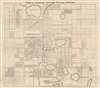
Map of Orlando, Orange County, Florida.
Orlando get's its second wind...
Choose a Collection:
- Digital Map Information
- Suitable for large format printing
- Full resolution TIFF file
- ICC color profile embedded
- Delivered instantly via download link
This Item
Enquire
Orlando get's its second wind...
This is a 1910 South Florida Sentinel city plan or map of Orlando, Florida at the beginning of the Florida Land Boom. Depicting from Concord Lake to Copeland Lake and from just west of Reel Street to Sink Lake, the map provides a detailed look at Orlando at the beginning of the 20th century. Forty-three locations are numerically identified and correspond with an index (labeled 'Explanations') situated in the upper left. Housing additions are illustrated and labeled with the developer's name. In some cases, individual blocks are also labeled.Verso Content
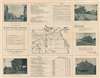
A map of Orange County occupies the center of the verso and is framed by information about the city, with photographs of locations around Orlando.Orlando, Florida
Orlando, Florida, was founded during the Reconstruction Era on July 31, 1875, with just 85 residents (only 22 of which were voters). Initially floundering, the charter was revoked in 1879, but it was reincorporated as a city in 1885. The subsequent decade proved to be a boom time for Orlando (and indeed most of Florida). It became the heart of Florida's growing Citrus industry. The Citrus Boom ended in 1895 following the Great Freeze of 1894-95, when most citrus growers either went out of business or moved south. As this map was issued, Orlando was catching its second wind. Easily accessible by rail, the city emerged from the Great Freeze as a popular tourist destination. In Orlando, 1910 marked the beginning of the Florida Land Boom, a good 10 years ahead of the rest of Florida - as evidenced on this map.Publication History and Census
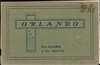
This map was published by the South Florida Sentinel in a booklet entitled 'Orlando: the Charm of the South' published in 1910. Three examples of the booklet are cataloged in OCLC and are part of the institutional collections at the University of Central Florida, the University of South Florida, and the University of Miami. No examples of the separate map appear to be cataloged.Cartographer
The South Florida Sentinel (1885 - 1918) was an American weekly newspaper in Orlando, Florida. It was published by Latimer C. Vaughn. Further Details...
Source
Sentinel Print, 'Orlando: the Charm of the South,' (Sentinel Print: Orlando) 1910.
Condition
Very good. Exhibits light wear along original fold lines. Verso repairs to closed tears along upper margin. Text and printed images on verso.
References
OCLC 5281509.