1915 Ordnance Survey Map of German East Africa, Mt. Kilimanjaro Region, World War I
OstafrikaKilimanjaro-ordnance-1915$1,600.00


Title
German East Africa. Kilimanjaro. GBE.
1915 (dated) 26 x 33.5 in (66.04 x 85.09 cm) 1 : 300000
1915 (dated) 26 x 33.5 in (66.04 x 85.09 cm) 1 : 300000
Description
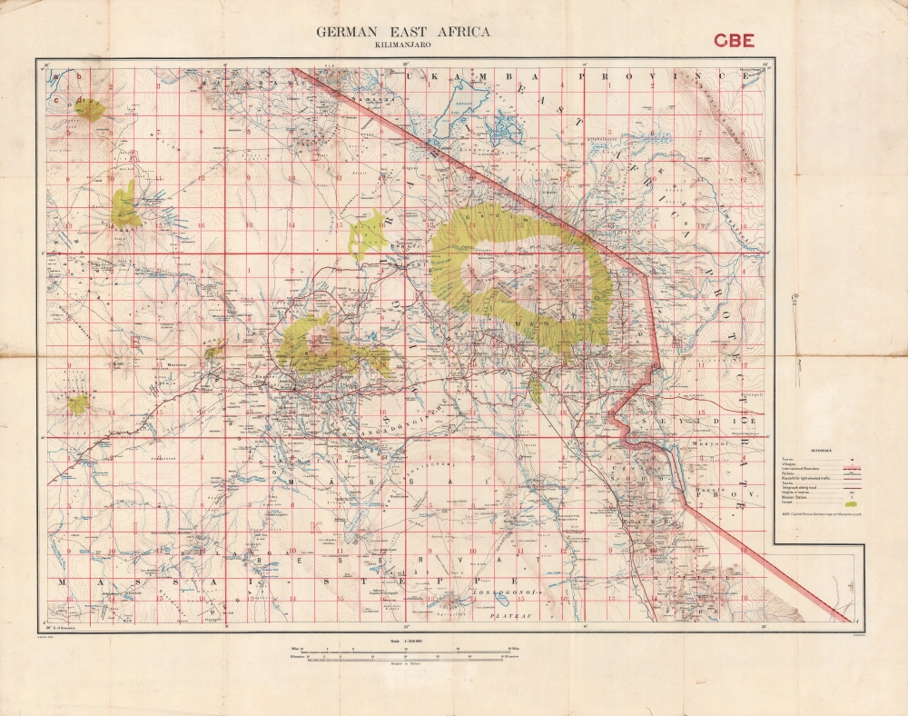
A highly detailed 1915 Ordnance Survey map of the region around Mt. Kilimanjaro, produced in the opening phase of the East Africa Campaign during World War I (1914 - 1918). This area saw some of the earliest fighting in Africa of the war, battles in which British forces fared badly against numerically inferior but wily German opponents.
The Usambara Railway (also briefly known as the Northern Railway) is seen running to Moshi just south of Mt. Kilimanjaro. Begun in 1891 from the port of Tanga, on the Indian Ocean, it reached Moshi in late 1911. The railway was intended to be extended to Arusha (Aruscha here), due west of Moshi, but was never completed due to the war. Though primarily intended for transporting agricultural products (the Germans had set up large plantations for coffee, rubber, and other commodities), this and other railways in East Africa became key military objectives during the East Africa Campaign.
The East Africa campaign is significant not only for the changes it brought to the region's geography and political arrangements, but because of the postwar activities of its major antagonists. Lettow-Vorbeck returned to Germany as a hero and helped to put down the Spartacist uprising in 1919. After being implicated in the failed Kapp Putsch of 1920, Lettow-Vorbeck left the army and later entered politics. He was oriented on the far right but had a difficult and testy relationship with the Nazis. The main Allied commander, Jan Smuts (1870 - 1950), became the Prime Minister of South Africa and played an important role in the creation of the League of Nations and later the United Nations.
A Closer Look
Towns and villages, roads of various qualities, rail lines, telegraphs, mission stations, and terrain are indicated in great detail throughout. Particularly important for military planners are notes on elevation, water sources (which changed seasonally), and landscape. A grid overlays the map, subdividing latitude and longitude lines into discrete parcels that could be used for precise reference. Faint handwritten notes at bottom provide formulas for converting between meters and feet. As mentioned at bottom-right, this map was copied from a German map, with some additions and corrections, a common practice by Allied forces during the East Africa Campaign.The Usambara Railway (also briefly known as the Northern Railway) is seen running to Moshi just south of Mt. Kilimanjaro. Begun in 1891 from the port of Tanga, on the Indian Ocean, it reached Moshi in late 1911. The railway was intended to be extended to Arusha (Aruscha here), due west of Moshi, but was never completed due to the war. Though primarily intended for transporting agricultural products (the Germans had set up large plantations for coffee, rubber, and other commodities), this and other railways in East Africa became key military objectives during the East Africa Campaign.
Early Battles in East Africa
Taveta, towards bottom-right, in the portion of the British East Africa Protectorate that jutted into German East Africa, was the site of the campaign's first battle, on August 15, 1914, though it was a bloodless affair with British forces retreating after firing a symbolic volley. In early November of that year, more significant fighting took place in the region (the Battle of Kilimanjaro), a fairly disastrous British attempt to gain control of the area around the mountain. Though the British outnumbered the defenders by a wide margin, the Germans had prepared defenses and launched ambushes on British supply trains, gaining food and ammunition for themselves in the process. The German commander, Paul von Lettow-Vorbeck (1870 - 1964), would remain a thorn in the side of Allied troops throughout the conflict, successfully employing guerilla tactics to ward off much larger enemy forces. It is worth pointing out that most of the troops on both sides were colonial subjects, either askaris, or, on the British side, Indian troops.The East Africa Campaign
Unlike the trench warfare of the Western Front, the conflict in Africa was defined by mobile frontier campaigns, fought largely by colonial troops and African conscripts called askari. In East Africa, the outnumbered German forces under Paul Emil von Lettow-Vorbeck repeatedly defeated or otherwise tied down their foes with guerilla tactics, inspired by Lettow-Vorbeck's earlier battles against insurgents in German Southwest Africa. Nevertheless, after bringing in reinforcements and drafting a massive labor force of porters, the British and Belgians launched a largely successful offensive in the spring of 1916 that resulted in the capture of most of the northern portion of German East Africa. By September 1916, British troops controlled the railways and German troops had been pushed to the south, where they would hold out until the end of the war, continuing their effective use of guerrilla tactics and even launching offensives into Portuguese Mozambique and British Rhodesia.The East Africa campaign is significant not only for the changes it brought to the region's geography and political arrangements, but because of the postwar activities of its major antagonists. Lettow-Vorbeck returned to Germany as a hero and helped to put down the Spartacist uprising in 1919. After being implicated in the failed Kapp Putsch of 1920, Lettow-Vorbeck left the army and later entered politics. He was oriented on the far right but had a difficult and testy relationship with the Nazis. The main Allied commander, Jan Smuts (1870 - 1950), became the Prime Minister of South Africa and played an important role in the creation of the League of Nations and later the United Nations.
Publication History and Census
This map was produced in 1915 by the British Ordnance Survey and was one of a series produced by them for the Geographical Section of the General Staff (abbreviated and coded at bottom-left). It is noted among the holdings of the University of Cape Town, the British National Archives, the University of Cambridge, the University of Nottingham, the British Library, the United Nations Archives in Geneva, and the National Library of Australia. Most of these catalog listings are in special collections, such as the papers of British military officers from the era. The map is very scarce to the market.Cartographer
The British Ordnance Survey (1791 - present) is the national mapping agency of Great Britain and is one of the largest producers of maps in the world. This non-ministerial department of the government of the United Kingdom is responsible for producing maps of Great Britain and many of its overseas possessions. The history of the Ordnance Survey goes back as far as 1747, following the Jacobite rising, when King George II commissioned a comprehensive military survey of Scotland to assist further campaigns. The result, produced by Paul Sandby, John Mason and William Roy, was the Duke of Cumberland's Map, the first military quality map of the British Isles. This grew into the Principal Triangulation of Great Britain (1783-1853) under William Roy, and eventually lead to the creation of the Ordnance Survey in 1791. Today the Ordnance Survey produces a large variety of paper maps and digital mapping products. Its large scale maps, issued to the scale of 1:10000, available in sheet map form until the 1980s, are now only available digitally. All maps produced by the Ordnance Survey are in copyright for 50 years after publication. More by this mapmaker...
Condition
Good. Toning and wear along fold lines. Wear and some fraying in margins and along edge. Mounted on linen.
References
OCLC 903416038.