This item has been sold, but you can get on the Waitlist to be notified if another example becomes available, or purchase a digital scan.
1861 Ensign Pro-Union Broadside; Start of the U.S. Civil War, Fort Sumter
OurNationsCamp-ensign-1861$1,000.00

Title
Our Nation's Camp Ground.
1861 (dated) 25.5 x 16 in (64.77 x 40.64 cm)
1861 (dated) 25.5 x 16 in (64.77 x 40.64 cm)
Description
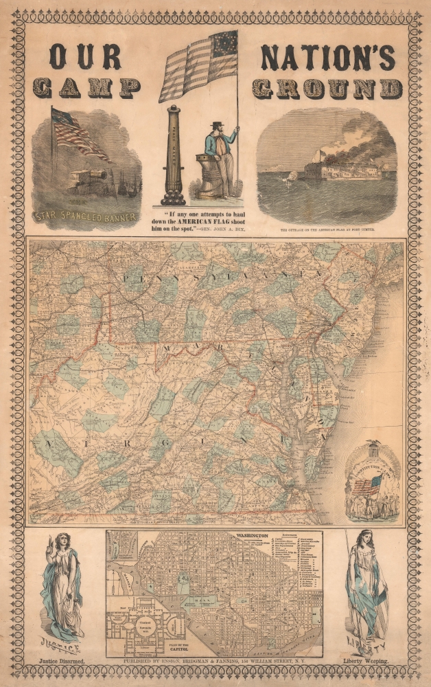
A remarkable piece of persuasive cartography from the early days of the U.S. Civil War, this Ensign, Bridgman, and Fanning broadside was produced in 1861 in the wake of the Confederate attack on Fort Sumter. Including two maps and six illustrations, the sheet is a comprehensive call to arms for the Union.
At bottom-center is a city plan of Washington, D.C., revealing significant changes taking place, including land reclamation along the Potomac (indicated by 'ghosted in' roads), the ongoing renovation of the U.S. Capitol (presented in a schematic at bottom-left), and the development of the National Mall with the recently-built Smithsonian Institution (the 'Castle') and the still-incomplete Washington Monument.
The top third of the sheet is dominated by rousing patriotic illustrations and text. At left is a depiction of the Star-Spangled Banner, referring to the trials of the War of 1812 and foreshadowing the challenges ahead for the Union. At center is a cannon titled 'Peacemaker' and its operator holding an American flag with stylized star field. At right is a depiction of the shelling of Ft. Sumter, generally seen as the formal start of the U.S. Civil War. The 'outrage on the American flag at Fort Sumter' refers not only to the flag as a symbolic representation of the Union, but also the actual flagpole at the fort, which was hit by one of the 3,000 Confederate rounds fired at the fort on April 12 - 13, 1861. At bottom-right of the main map is an illustration with the words 'Constitution and Laws' and Abraham Lincoln holding an American flag surrounded by figures representing various classes and professions of the citizenry. On either side of the Washington, D.C. plan are illustrations of 'Justice Disarmed' and 'Liberty Weeping,' respectively.
The memorable quote 'If any one attempts to haul down the American flag, shoot him on the spot' from John Adams Dix appears below the canon at top-center. Dix was a former U.S. Senator from New York who briefly served as Secretary of the Treasury in the waning days of President James Buchanan's administration, as the country broke in two and prepared for civil war. His most memorable act as Secretary of the Treasury was to send a telegram to a Treasury office in New Orleans with the quote here. Though the telegram was intercepted by Confederates and never delivered, it was reported in the press and became a Union rallying cry in the early days of the war. In part because of his experience in the Army, albeit more than 30 years earlier, Dix was given the title of Major General and commanded the New York militia. He was, in effect, the highest-ranking officer for all Union volunteer troops at the start of the war and played an important role in arranging logistics and in arresting six members of Maryland's General Assembly (the body favored staying in the Union but not engaging in hostilities with the rebellious southern states). He was later involved in the suppression of the New York Draft Riots, but due to his age saw limited opportunities for field command during the war.
A Closer Look
This hand-colored sheet is structured around a large map of the mid-Atlantic states - the expected and actual 'seat of the war' - including Virginia, Pennsylvania, New Jersey, Delaware, Maryland, and portions of Ohio and North Carolina. Though West Virginia had already begun the process of breaking away from Virginia, the state is presented as unitary here, as was common on maps published in the North, where the government in Wheeling was considered the legitimate government of Virginia. Counties, cities, roads, railways, mountains, waterways, and other features are clearly labeled throughout.At bottom-center is a city plan of Washington, D.C., revealing significant changes taking place, including land reclamation along the Potomac (indicated by 'ghosted in' roads), the ongoing renovation of the U.S. Capitol (presented in a schematic at bottom-left), and the development of the National Mall with the recently-built Smithsonian Institution (the 'Castle') and the still-incomplete Washington Monument.
The top third of the sheet is dominated by rousing patriotic illustrations and text. At left is a depiction of the Star-Spangled Banner, referring to the trials of the War of 1812 and foreshadowing the challenges ahead for the Union. At center is a cannon titled 'Peacemaker' and its operator holding an American flag with stylized star field. At right is a depiction of the shelling of Ft. Sumter, generally seen as the formal start of the U.S. Civil War. The 'outrage on the American flag at Fort Sumter' refers not only to the flag as a symbolic representation of the Union, but also the actual flagpole at the fort, which was hit by one of the 3,000 Confederate rounds fired at the fort on April 12 - 13, 1861. At bottom-right of the main map is an illustration with the words 'Constitution and Laws' and Abraham Lincoln holding an American flag surrounded by figures representing various classes and professions of the citizenry. On either side of the Washington, D.C. plan are illustrations of 'Justice Disarmed' and 'Liberty Weeping,' respectively.
The memorable quote 'If any one attempts to haul down the American flag, shoot him on the spot' from John Adams Dix appears below the canon at top-center. Dix was a former U.S. Senator from New York who briefly served as Secretary of the Treasury in the waning days of President James Buchanan's administration, as the country broke in two and prepared for civil war. His most memorable act as Secretary of the Treasury was to send a telegram to a Treasury office in New Orleans with the quote here. Though the telegram was intercepted by Confederates and never delivered, it was reported in the press and became a Union rallying cry in the early days of the war. In part because of his experience in the Army, albeit more than 30 years earlier, Dix was given the title of Major General and commanded the New York militia. He was, in effect, the highest-ranking officer for all Union volunteer troops at the start of the war and played an important role in arranging logistics and in arresting six members of Maryland's General Assembly (the body favored staying in the Union but not engaging in hostilities with the rebellious southern states). He was later involved in the suppression of the New York Draft Riots, but due to his age saw limited opportunities for field command during the war.
Publication History and Census
This broadside was published by Edward Hooker Ensign, Erastus Bridgman, and Thomas Fanning in New York. It is undated but, from context, can be presumed to date from the second half of 1861. The only example of this broadside in institutional collections is with the David Rumsey Historical Map Collection, which is also cataloged with Stanford University.CartographerS
Edward Hooker Ensign (August 18, 1818 - July 10, 1871) was an American map and print publisher based in New York during the middle part of the 19th century. Edward was born in West Hartland, Connecticut. Little is known of Ensign's training but he may have inherited his business from his father, Timothy Ensign (1795 - 1859), who was a map publisher active in New York. Ensign seems to have had a flair for partnerships and variously published with Humphrey Phelps (1799 - 1875), Horace Thayer, Thomas C. Fanning (1805 - 1873) and Erastus C. Bridgman (1817 - 1870), among others. His various imprints include 'Phelps and Ensign' (1841-1844), 'T. and E. H. Ensign' (1844-1848), 'Ensign and Thayer' (1849), 'Ensign, Thayer, and Company' (1850-1851), 'Horace Thayer and Company' (1852), and 'Ensign, Bridgman and Fanning' (1854-1863). It appears that father and son worked together for some time as well, publishing as either 'T. and E. H. Ensign' or 'Ensigns'. At least some of these companies maintained offices in both Buffalo and New York City. More by this mapmaker...
Erastus Clark Bridgman (October 31, 1817 - August 25, 1870) was a New York City based map publisher active in the middle of the 19th century. Bridgman was born in Westhampton, Massachusetts. He was in South Carolina in 1849, where his first child was born, but moved to New York City by 1850. Bridgman was in partnership with Edward H. Ensign (1818 - 1871) and Horace Thayer from 1850 - 1852, publishing under the imprint of 'Ensign, Thayer, and Co.' Later, from 1854 - 1863, the partnership changed to Edward H. Ensign, Thomas C. Fanning (1805 - 1873), and Bridgman, publishing as 'Ensign, Bridgman and Fanning.' After his death, the Bridgman firm was taken over by his son Edward Clark Bridgman (1849 - 19??). Learn More...
Thomas Colt Fanning (August 2, 1805 - November 21, 1873) was a New York based map publisher active in the middle part of the 19th century. Fanning was born in Norwich, Connecticut. As a young man he apprenticed at a drugstore in Rochester, New York. When he reached his maturity, he relocated to Albion, New York, where he opened the town's first drugstore. He sold this business in 1849 to move to Brooklyn and enter the map publishing business. He initially partnered with Humphrey Phelps (1799 - 1875) and Thomas C. Fanning (1805 - 1873), joining the firm of 'Phelps and Fanning' as a junior partner. From 1854 to 1863 he partnered with Edward H. Ensign (1818 - 1871) and Erastus Clark Bridgman (1817 - 1870), publishing as 'Ensign, Bridgman and Fanning.' Learn More...
Condition
Good. Even overall toning. Laid down on archival tissue. Some restoration lower right corner. A few scrapes and surface abrasions.
References
Rumsey 5438.000. OCLC 953569381.