This item has been sold, but you can get on the Waitlist to be notified if another example becomes available, or purchase a digital scan.
1842 Mather Map of Oyster Pond Point, Long Island, New York
OysterPondPoint-mather-1842$62.50

Title
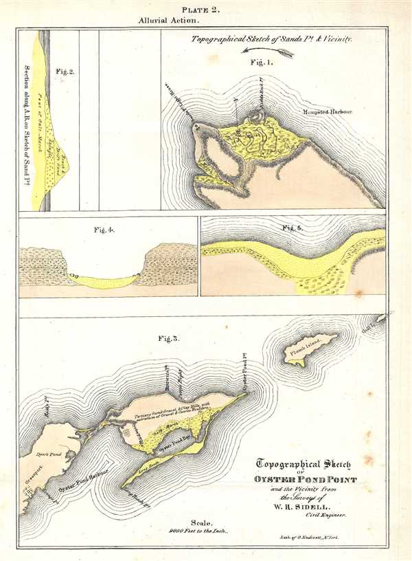
Topographical Sketch of Oyster Pond Point and the Vicinity from the Surveys of W. H. Sidell.
1842 (undated) 10.75 x 7.75 in (27.305 x 19.685 cm) 1 : 108000
1842 (undated) 10.75 x 7.75 in (27.305 x 19.685 cm) 1 : 108000
Description
This is an 1842 William Mather lithograph plate from his Geology of New York, Part I depicting Oyster Pond Point and Sands Point, Long Island. Today, the areas in Figure 3 labeled here as Oyster Pond Harbour and Oyster Pond Bay are known as the Peconic River and Long Beach Bay. Figure 3 depicts from East Marion, Long Island to Plum Island. Figures 4 and 5 illustrate alluvial drift and the depositing of boulders around Oyster Pond Point. Figure 1 illustrates the region around Sands Point, which lies between Hempstead Bay and Manhasset Bay. The Sands Point lighthouse is labeled. Figure 2 is a cross section of Sands Point, enhancing the viewer's understanding of the geological make-up of the area.
The topography for this plate was sketched by W.H. Sidell, a civil engineer, engraved by George Endicott, and published in William Mather's Geology of New York, Part I in 1842.
The topography for this plate was sketched by W.H. Sidell, a civil engineer, engraved by George Endicott, and published in William Mather's Geology of New York, Part I in 1842.
CartographerS
William W. Mather (May 24, 1804 - February 26, 1859) was an important American geologist and natural historian. Mather was born in Brooklyn, Connecticut to an old New England family. In 1823, as a young man, he entered the West Point military academy after which he served as a 2nd Lieutenant in the Seventh Infantry. His interest in Chemistry and mineralogy soon called him back to West Point where he acted as an Assistant Professor of Geology. After resigning from the Army in 1834 with a rank of 1st Lieutenant, Mather accepted a position as Professor of Chemistry at the University of Louisiana. Later he was employed as Professor of Natural History and Sciences at the University of Ohio, was appointed Geologist of the First Geological District of New York for Governor William H. Seward, and was the State Geologist of both Ohio and Kentucky. In 1847 Mather became president of the University of Ohio. During his long career Mather made copious notes regarding his geological explorations, published profusely, and had a lively and extensive correspondence - much of which remains accessible to this day. Mather reports on one humorous incident in Long Island where, while collecting rock specimens, he had a run-in with a local farmer. The famer, observing the care with which Mather collected and cataloged his rock specimens, assumed that Mather had, in fact, discovered gold! Mather died in Columbus, Ohio on February 26, 1859. Today the W.W. Mather Medal is an important Geologic Reserach commendation. (Collections of the Minnesota Historical Society, p. 133.) More by this mapmaker...
Endicott and Company (fl. c. 1828 - 1891) was a New York based family run lithography firm that flourished throughout the 19th century. The firm was founded by George and William Endicott, brothers who were born in Canton, Massachusetts. George Endicott (June 14, 1802 - 1848) trained as a lithographer under Pendleton Lithography from January 1826. He later worked as superintendent of Senefelder Company until the summer of 1828. Afterwards, in 1830, he relocated to Baltimore and partnered with Moses Swett. Endicott and Swett relocated to New York City in December 1831. They remained partners until July 1834 when the relationship dissolved. George set up shop on his own account at 359 Broadway. William Endicott (1815 - 1851), George's younger brother of 14 years, joined the firm in 1840 and was made a partner in 1845, after which the name of the firm was changed to G. and W. Endicott. George Endicott died shortly afterward, in 1848, but William continued operating the firm as William Endicott and Co. until his own 1851 death at just 35 years old. The firm was carried on by his widow Sara Munroe Endicott until it was taken over by her son, Francis Endicott, who ran the firm from 1852 to 1886. George Endicott, Jr. subsequently ran the firm from 1887 to 1891. Peters, in his important work on American lithography America on Stone writes 'it is hard to summarize the Endicotts. They did everything and did it well . . . [they] worked with and for Currier and Ives, yet in spite of all that much of their work lacks real individuality.' The Endicott firm was responsible for many 19th century views and plans of New York City and state as well as plans of Sacramento, California, and the Midwest. Learn More...
Source
Mather, W. W., Geology of New York, Part 1, 1842.
Condition
Very good. Even overall toning. Blank on verso.