1850 Cowperthwait - Mitchell Map of Pennsylvania
PA-m-50$250.00
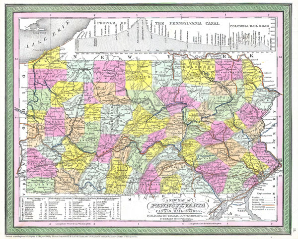

Title
A New Map of Pennsylvania with its Canals, Rail-Roads & c.
1850 12 x 14 in (30.48 x 35.56 cm)
1850 12 x 14 in (30.48 x 35.56 cm)
Description
This hand colored map is a copper plate engraving, dating to 1850 by the legendary American Mapmaker S.A. Mitchell, the elder. It represents Pennsylvania. Contains notes on steamboat stops and routes between Pittsburg and Louisville, Philadelphia and New York both via Trenton and via Bordentown, and from Philadelphia to Baltimore via New Castle. Upper portion of the map is dedicated to a profile of the Pennsylvania Canal and the Columbia Railroad. This historically important map is extremely rare as it existed only in the 1850 edition of the Mitchell's Universal Atlas.
Cartographer
Samuel Augustus Mitchell (March 20, 1792 - December 20, 1868) began his map publishing career in the early 1830s. Mitchell was born in Bristol, Connecticut. He relocated to Philadelphia in 1821. Having worked as a school teacher and a geographical writer, Mitchell was frustrated with the low quality and inaccuracy of school texts of the period. His first maps were an attempt to rectify this problem. In the next 20 years Mitchell would become the most prominent American map publisher of the mid-19th century. Mitchell worked with prominent engravers J. H. Young, H. S. Tanner, and H. N. Burroughs before attaining the full copyright on his maps in 1847. In 1849 Mitchell either partnered with or sold his plates to Thomas, Cowperthwait and Company who continued to publish the Mitchell's Universal Atlas. By about 1856 most of the Mitchell plates and copyrights were acquired by Charles Desilver who continued to publish the maps, many with modified borders and color schemes, until Mitchell's son, Samuel Augustus Mitchell Junior, entered the picture. In 1859, S.A. Mitchell Jr. purchased most of the plates back from Desilver and introduced his own floral motif border. From 1860 on, he published his own editions of the New General Atlas. The younger Mitchell became as prominent as his father, publishing maps and atlases until 1887, when most of the copyrights were again sold and the Mitchell firm closed its doors for the final time. More by this mapmaker...
Condition
Fine or perfect condition. Wide margins. Blank on verso.