
1894 Rand McNally Map of the Pacific Coast from San Diego to Chilkat, Alaska

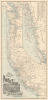
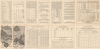
Map Showing Routes of the Pacific Coast Steamship Company.
Tourism from Chilkat, Alaska, to San Diego, California.
- Digital Map Information
- Suitable for large format printing
- Full resolution TIFF file
- ICC color profile embedded
- Delivered instantly via download link
Tourism from Chilkat, Alaska, to San Diego, California.
This is a scarce 1894 Rand McNally map of the Pacific Coast of North America, produced to promote tourism and travel with the Pacific Coast Steamship Company just a few years before the Klondike Gold Rush (1896 - 1898). The map illustrates the Pacific Coast from the Mexican border to British Columbia and Vancouver Island; an inset details the route north to 'Mousouah Lake' (Mosquito Lake) in Alaska.A Tourist Brochure
The target audience was primarily tourists: the verso text pitches a month-long sightseeing journey to Alaska from San Francisco, and the illustrations on the map's covers and cartouche highlight the dramatic vistas. The map's cartouche offers a vignette of the Thousand Islands as viewed from Sitka, while the front cover presents a view of the steamship Idaho navigating Glacier Bay. The cover illustrations depict totem poles at Kasa-An Village in Alaska and Point Bonita, the entrance to the Golden Gate.Rich in Data
The map marks out both express and local routes north and south from San Francisco, and features tables indicating distances. The verso details ticket prices, schedules, and ticket agents. The verso text also includes detailed descriptions of featured destinations.Differences Between Editions
We have been privileged to handle two different editions of this map: the present 1894 edition and an 1889 edition (see PacificCoast-randmcnally-1889). Surprisingly, during the intervening 5 years, the Pacific Coast Steamship Company changed its routes in California. In 1894, they added stops at Santa Monica and Redondo Beach and removed the port of call at Newport. The company also added a Mexican Route that steamed directly from San Francisco to San Diego and continued south.The Pacific Coast Steamship Company
When this brochure was published, the company was running two steamboats up the coast to Alaska. One of these, the Ancon, would have its career cut short later the same year when it ran aground and broke in Loring, Alaska (happily, without casualty). Since we see editions of this map produced as late as 1911, it must be presumed that this disaster did not ruin the company and that the tourist trade (and the subsequent Yukon Gold Rush) was able to keep them busy. We are left to speculate what other cargos the Steamship Company carried: the ship depicted in the Glacier Bay vignette, the Idaho, had been caught smuggling opium in the early 1880s.Publication History and Census
OCLC lists 13 examples of this map in 7 editions ranging between 1886 and 1911. Only two examples of the 1889 edition were located, one at the San Francisco Maritime National Historical Park and the other at the Wisconsin Historical Society Library.Cartographer
Rand, McNally and Co. (fl. 1856 - present) is an American publisher of maps, atlases and globes. The company was founded in 1856 when William H. Rand, a native of Quincy, Massachusetts, opened a print shop in Chicago. Rand hired the recent Irish immigrant Andrew McNally to assist in the shop giving him a wage of 9 USD per week. The duo landed several important contracts, including the Tribune's (later renamed the Chicago Tribune) printing operation. In 1872, Rand McNally produced its first map, a railroad guide, using a new cost effective printing technique known as wax process engraving. As Chicago developed as a railway hub, the Rand firm, now incorporated as Rand McNally, began producing a wide array of railroad maps and guides. Over time, the firm expanded into atlases, globes, educational material, and general literature. By embracing the wax engraving process, Rand McNally was able to dominate the map and atlas market, pushing more traditional American lithographic publishers like Colton, Johnson, and Mitchell out of business. Eventually Rand McNally opened an annex office in New York City headed by Caleb S. Hammond, whose name is today synonymous with maps and atlases, and who later started his own map company, C. S. Hammond & Co. Both firms remain in business. Further Details...
Condition
Good. Wear along original fold lines. Verso repairs to fold separations and at fold intersections. Slight loss at some fold intersections. Steamship schedules on verso.
References
Rumsey 5232.001 (1896). OCLC 45178306.