This item has been sold, but you can get on the Waitlist to be notified if another example becomes available, or purchase a digital scan.
1835 Hall Map of the Pacific Ocean, Australia, and Polynesia
PacificOcean-hall-1835$150.00

Title
Pacific Ocean.
1835 (undated) 17 x 21 in (43.18 x 53.34 cm) 1 : 44100000
1835 (undated) 17 x 21 in (43.18 x 53.34 cm) 1 : 44100000
Description
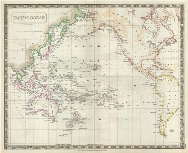
This is a beautiful map of the Pacific Ocean, Australia, and Polynesia from Sidney Hall's extremely scarce 1835 New General Atlas. Centered on the Sandwich or Hawaiian Islands, it depicts the entirety of the Pacific Basin along with portions of the surrounding continents. The map covers from the Bering Strait south as far as Cape Horn and from Burma (Myanmar) east as far as the western coast of Greenland. Although the interiors of the continents remain blank, the coastal regions are highly detailed. Numerous islands of Polynesia, Melanesia and Micronesia are noted along with the years of their discovery. Hawaii's Karakakoa Bay (Kealakekua Bay), bears the note 'here Captain Cook was killed on Sunday, Feb 14, 1779.' Hawaii is here identified by the older English spelling 'O-Why-Hee.'
The map offers copious notations throughout, such as 'Christian, one of the Mutineers of the Bounty attempted to form a settlement here in 1789,' and on Pitcairn's Island, 'This Island is inhabited by the Children of some of the Mutineers of the Bounty, who after going to Otaheite, where there married some of the Otaheitans, settled here in 1790.' Clearly though occurring nearly 60 years prior, the romantic adventures of Fletcher Christian, who lead the Bounty mutiny against Captain Bligh, remained very much on the minds of the British.
Sidney Hall's New General Atlas was published from 1830 to 1857, the first edition being the most common, with all subsequent editions appearing only rarely. Most of the maps included in the first edition of this atlas were drawn between 1827 and 1828 and are most likely steel plate engravings, making it among the first cartographic work to employ this technique. Each of the maps in this large and impressive atlas feature elegant engraving and an elaborate keyboard style border. Though this is hardly the first map to employ this type of border, it is possibly the earliest to use it on such a large scale. Both the choice to use steel plate engraving and the addition of the attractive keyboard boarder are evolutions of anti-forgery efforts. Copper plates, which were commonly used for printing bank notes in the early 19th century, proved largely unsuitable due to their overall fragility and the ease with which they could be duplicated. In 1819 the Bank of England introduced a £20,000 prize for anyone who could devise a means to print unforgeable notes. The American inventors Jacob Perkins and Asa Spencer responded to the call. Perkins discovered a process for economically softening and engraving steel plates while Spencer invented an engraving lathe capable of producing complex patters repetitively - such as this keyboard border. Though Perkins and Spenser did not win the prize, their steel plate engraving technique was quickly adopted by map publishers in England, who immediately recognized its value. Among early steel plate cartographic productions, this atlas, published in 1830 by Longman Rees, Orme, Brown & Green stands out as perhaps the finest. This map was issued by Sidney Hall and published by Longman Rees, Orme, Brown & Green of Paternoster Row, London, in the 1835 edition of the Sidney Hall New General Atlas.
Cartographer
Sidney Hall (1788 - 1831) was an English engraver and map publisher active in London during the late 18th and early 19th centuries. His earliest imprints, dating to about 1814, suggest a partnership with Michael Thomson, another prominent English map engraver. Hall engraved for most of the prominent London map publishers of his day, including Aaron Arrowsmith, William Faden, William Harwood, and John Thomson, among others. Hall is credited as being one of the earliest adopters of steel plate engraving, a technique that allowed for finer detail and larger print runs due to the exceptional hardness of the medium. Upon his early death - he was only in his 40s - Hall's business was inherited by his wife, Selina Hall, who continued to publish under the imprint, "S. Hall", presumably for continuity. The business eventually passed to Sidney and Selina's nephew Edward Weller, who became extremely prominent in his own right. More by this mapmaker...
Source
Hall, S., A New General Atlas, with the Divisions and Boundaries, 1835.
Condition
Very good. Original platemark visible. Minor wear along original centerfold. Some offsetting. Blank on verso.
References
Rumsey 4224.035 (1830 edition). Philips (Atlases) 758. Ristow, W., American Maps and Mapmakers: Commercial Cartography in the Nineteenth Century, p. 303-09.