This item has been sold, but you can get on the Waitlist to be notified if another example becomes available, or purchase a digital scan.
1945 Owens Map of the Pacific Ocean and the Pacific War During WWII
PacificPicture-owens-1945$175.00

Title
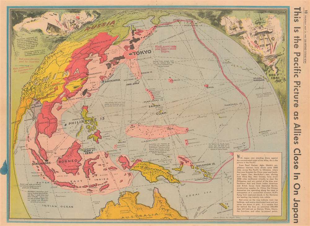
This is the Pacific Picture as Allies Close in on Japan.
1945 (dated) 16 x 22 in (40.64 x 55.88 cm)
1945 (dated) 16 x 22 in (40.64 x 55.88 cm)
Description
This is a 1945 Charles Owens map of the Pacific highlighting the current state of affairs in the Pacific War only a couple weeks after Allied victory in Europe. In a style reminiscent of Richard Edes Harrison, the map depicts the region from China and India to Hawaii and from the Aleutian Islands and Russia to Australia. Owens uses color highly effectively to convey the areas of Japanese invasion (dark red), and influence (pink) to provide the viewer with immediate understanding of just how much territory the Japanese still control, even after victory was achieved in Europe.
The Pacific Situation
Gains have been made in the Pacific, particularly with the liberation of Burma in Southeast Asia, in the Solomon Islands, Marshall Islands, Mariana Islands, and the Philippines. Advances by the Chinese near the coast are also highlighted, and in the text box in the lower right corner the fact that American B-29s from the Marianas are bombing Japan renders evident the successes the Allies have won in this theater. The dashed pink line, encircling most of the western Pacific and representing the farthest reaches of Japanese expansion, also makes it quite evident how far the Japanese have been pushed back in three and a half years of war. A vignette in the upper right corner brilliantly illustrates the Japanese attack on Pearl Harbor on December 7, 1941, depicting what appears to be the explosion of the magazine on the USS Arizona and reminding Americans viewing this map in their daily newspaper why their young men were still fighting in the Pacific. A vignette in the opposite corner illustrates American planes attacking and sinking a Japanese battleship.Island Hopping
One of the military strategies unique to the Pacific War was the ‘leapfrogging’ or island hopping’ strategy adopted by the Allies. Strongly supported by General Douglas MacArthur, this strategy called for bypassing certain heavily fortified islands in the Pacific in favor of more important targets. The ‘leapfrogged’ islands would then be cut off from resupply by the advancing Allied forces and would ‘wither on the vine’. Very few maps of the Pacific War illustrate this strategy as well as this one. By using the pink to shade where Japanese forces were still present, and the yellow to show the American and Australian advance through the South and Central Pacific, ‘leapfrogged’ islands, such as Truk in the Caroline Islands, and Marcus and Wake Islands as is pointed out on the map, are easily recognized.Publication History
This map was created by Charles Owens of the Los Angeles Times and published by the San Antonio Evening News on Thursday, May 24, 1945.Cartographer
Charles Hamilton Owens (Feb 16, 1881 - March 3, 1958) was an American painter and illustrator and staff illustrator for the Los Angeles Times. Born in San Francisco, he had a passion for drawing from a young age. After landing a job as a messenger for The San Francisco Examiner, Owens began being taught his trade by the newspaper's illustrators. Although it is unclear exactly where Owens started his career as a newspaper staff artist, his reputation was launched by his detailed sketches of the 1906 San Francisco earthquake and fire for a New York paper, using only wire reports and his knowledge of the city. By 1910, Owens was working for the Los Angeles Examiner. Even at this point in his career, Owens was known for experimenting with new forms of illustration, fusing drawings of events with photographs. Owens's map of the Titanic disaster used a high oblique perspective, 'capturing the earth's sphericity and showing the polar regions on a curving horizon.' By the 1920s, Owens reputation as an artist in Los Angeles had grown beyond the realm of journalism. He had a studio and received commissions for landscapes and had exhibited watercolors of California and Hawaii landscapes. Thus, when Owens began creating his war series in April/May 1942, he had all the necessary skills to create visually striking works. The Los Angeles Times began a series of maps for its readers, which were full-page inserts that would appear every Monday and Saturday. Owens's maps would be included in the Monday issues, and a Rand McNally map would be included on Saturdays. The Rand McNally maps, however, were discontinued on June 27, 1942, but Owens's maps continued to be printed. His last war map was published on September 10, 1945, a little over a week after the Japanese surrender. Owens died in Los Angeles on March 3, 1958. More by this mapmaker...
Condition
Good. Newsprint. Closed one inch margin tear professionally repaired on verso. Blank on verso.