This item has been sold, but you can get on the Waitlist to be notified if another example becomes available, or purchase a digital scan.
1944 Chase Pictorial Map of the Pacific Ocean during World War II
PacificVictory-dudleychase-1944$187.50

Title
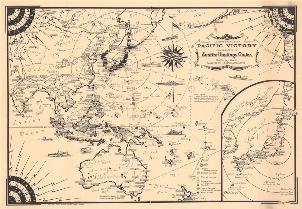
A Pictorial Map Pacific Victory.
1944 (dated) 16.25 x 23.5 in (41.275 x 59.69 cm)
1944 (dated) 16.25 x 23.5 in (41.275 x 59.69 cm)
Description
This is a 1944 Ernest Dudley Chase pictorial map of the Pacific Ocean during World War II. Depicting from central Asia to the west coast of the United States, Chase identifies islands throughout the Pacific, many of which were points of contention during the war.
A Closer Look
The Caroline Islands, Marshall Islands, Mariana Islands, and Solomon Islands (including Guadalcanal) are all identified. Individual islands within the Philippines are labeled as well. Japan and Korea (labeled here as both Korea and Chosen, the Japanese name for conquered Korea) are shaded black. Major and minor cities are labeled throughout as well, and the rail network in India (then a British colony) is illustrated in detail. Icons mark British, American, and French possessions and anchors mark naval bases from India to California. Pictorial illustrations of warships dot the Pacific and Indian oceans. An inset in the lower right corner focuses on Japan and Korea and illustrates the distances between the Japanese Home Islands and Okinawa, which the Allies invaded on April 1, 1945, after this map's publication.Publication History and Census
This map was created and published by Ernest Dudley Chase in 1944. The present map was compliments of the Austin-Hastings Co. Inc. of Cambridge, Massachusetts. This is the only known cataloged example of the 1944 edition. We note a single cataloged example of a 1945 edition (which appears unchanged from this 1944 edition), part of the David Rumsey Map Collection. The Rumsey example was compliments of a different company, suggesting that this piece was franchised for advertising.Cartographer
Ernest Dudley Chase (July 26, 1878 - August 25, 1966) was an American illustrator of greeting cards and pictorial maps active in the first half of the 20th century. From his studio in Winchester, Massachusetts, Chase became famous for his elaborately illustrated pictorial maps. He was born in Lowell, Massachusetts, and attended the Lowell Textile School and the Vesper George Art School. He took work with Butterfield Printing Company in 1900. In 1906, he moved to the W. T. Sheehan Printing Firm. He began producing postcards and greeting cards on his own account in 1908. This initial imprint was Des Arts Publishers, but later, he changed it to Ernest Dudley Chase Publishers. Chase is best known today for his distinctive pictorial maps, most of which he published privately, characterized by dense vignette images of important locations. The biographical pamphlet A Meticulous Maker of Maps describes Chase's attention to detail wherein, pursuing a 'passion for perfection' by stippling his images 'dot-by-dot, with tiny pens' under a magnifying glass. His impressive corpus includes nearly 50 maps focusing on various parts of the United States and Europe, as well as other international locations and novelty pieces. Most are thematic, focusing on topics such as wonders of the world, stamps, aviation, and war. Others, such as his map of The United States as viewed by California and Loveland are satirical. All, in their original editions, are coveted by a dedicated following of modern collectors. More by this mapmaker...
Condition
Good. Closed tear extending two-and-one-half (2.5) inches into printed area from right margin professionally repaired on verso. Some light cracking.
References
Rumsey 15061.000.