This item has been sold, but you can get on the Waitlist to be notified if another example becomes available.
1995 Metzler Infographic Map of the Pacific Theater Naval Battles During World War II
PacificWar-metzler-1995-2$225.00

Title
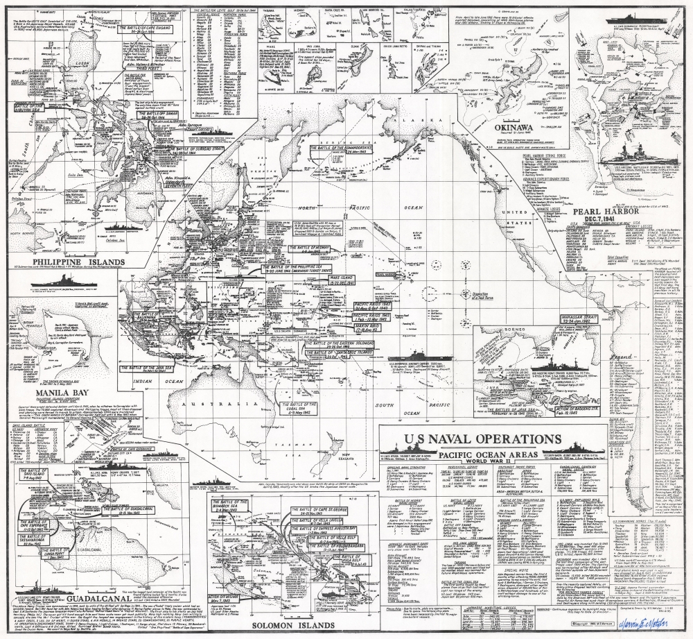
U.S. Naval Operations Pacific Ocean Areas World War II.
1995 (dated) 29.5 x 32 in (74.93 x 81.28 cm) 1 : 27500000
1995 (dated) 29.5 x 32 in (74.93 x 81.28 cm) 1 : 27500000
Description
This is a 1995 Marvin E. Metzler infographic map of the World War II Pacific War battles. It is a unique tribute to the Pacific war prepared by a veteran who experienced it firsthand.
A Closer Look
The central map depicts the entirety of the Pacific, from mainland Asia to the western coast of the Americas. Text boxes mark battles across the Pacific, including the Battle of the Philippine Sea, the Battle of Midway, the Battle of the Coral Sea, and the Doolittle Raid. Locations where American, Allied, and Japanese vessels sank are noted throughout, and a key situated in the lower right summarizes the iconography. Dashed lines follow the routes of various task forces, including the Japanese strike force that attacked Pearl Harbor on December 7, 1941. Profile illustrations of American and Japanese ships, including the U.S.S. Enterprise, the U.S.S. Salmon, and H.I.J.M.S. Yamato add detail. The U.S.S. Salt Lake City, the first ship Metzler served aboard, appears the lower left.The Insets
Eight large and ten small insets detail critical battles. The most recognizable, a map of the Japanese attack on Pearl Harbor, occupies the upper right. Metzler illustrates the direction from which each attack occurred, notes the time of each wave, and what type of aircraft took part. Locations are noted for ships damaged or sunk. A profile illustration of the U.S.S. Arizona occupies the peninsula between Pearl Harbor and the harbor entrance. Lists of the Pearl Harbor strike force, damaged and sunk American ships, aircraft losses, and total American casualties, occupy the bottom portion of the inset. The other large insets detail the Guadalcanal Campaign, the Battle of the Java Sea, the Solomon Islands, the Philippine Islands, and Manila Bay. Ten smaller insets situated at top center depict small islands that witnessed important moments in the Pacific War. Among these are Tarawa, Midway, Iwo Jima, Guam, Wake, Saipan, and Tinian.From The Fresno Bee
An article in the Wednesday, April 13, 1966, edition of The Fresno Bee profiled Metzler and the creation of thiw map. We have included the entire article below. (Italics ours)Despite the fact Marvin E. Metzler went through at least 5 major sea battles in World War II, there were many others involving ships, planes and men of the sea service he had only heard about. Hearing about them was not enough. Metzler wanted to know every little detail - the number of men and ships involved; what happened to the vessels, both of the United States and her allies, and Japan; the exact location of the fracas, and its outcome.
He soon learned that, no matter how well intentioned a historian may be, he often is not accurate. Reading three accounts of the same engagements often led to three differing versions. Metzler was looking for the correct version when he started his own research several years ago. This has led to what Metzler believes is the most authentic chart and map of the many battles fought at sea and near the islands of the Pacific.
Metzler already was a 'veteran' of naval service when World War II erupted with the attack on Pearl Harbor. He had left the Fresno Technical High School in July of 1937 to become a sailor, and was aboard the old USS Salt Lake City headed for Pearl when the attack came. Quite naturally, his chart begins with the incidents of Dec. 7, 1941. It lists the casualties of men and ships suffered in the blow, then moves on through the engagements near Java, the Coral Sea, Guadalcanal and on to later campaigns - Tarawa, Iwo Jima, the Philippines. He has painstakingly researched the names of the ships, their commanding officers, fleet leaders and their aircraft support. Many of the facts he remembers from having been in the thick of things. Some supporting evidence he has obtained from a brother, Lawrence, who also was in many of the battles as a sailor.
Metzler's compendium shows the opposing naval strength of the Japanese navy, giving the names of ships and commanding officers, as it stood on Dec. 7, 1941. Then he follows each through the war and shows, on a detailed map, where each met its fate. 'I had a tough time finding out where the different fleets, or units of fleets started from before each engagement, and where they went afterwards,' he said, 'But I found out, and their routes are shown on my map. 'It is natural, perhaps, that the USS Salt Lake City's whereabouts are adequately chronicled in the Fresnan's work.
He was aboard her when her big guns were trained on Wotje in the Marshalls to begin the first bombardment of an enemy shoreline in the war. 'We watched a Japanese torpedo sail directly under our steel bottom then hit and sink the Wasp,' he remembers. 'From her decks we saw the death blows dealt to the Hornet and the O'Brien. We watched the North Carolina take a torpedo, then helped get her ashore. 'Thirty ships were sunk in the battle of Iron Bottom Bay off Guadalcanal in 1942 - half of them ours and the other half theirs. This was before the tides of the sea war turned and our side began to take the upper hand. 'The exact locations of the graves of the 36 vessels are pinpointed on his map, and so are the last resting places of the men of war involved in the Savo Island Battles.
It is no coincidence that Metzler's map is a masterful bit of draftsmanship. He currently is the chief draftsman for Fresno district headquarters of the State Division of Highways. All day he drafts plans for highway development, then at night he puts the finishing touches on his map at home. He never really learned drafting, he says. 'I just grew up with it.' He left the Navy 20 years ago to make a home for his childhood sweetheart, Venita Wilson, who became his wife. But, obviously, the navy still holds a warm place in his heart. So does the old Salt Lake City. He felt tears in his eyes the day the old battle scarred cruiser finally was sunk off San Diego by units of the navy. 'She went through the atom bomb tests off Bikini, and was radioactive, so she was sunk,' he says. The Salt Lake City's final resting place is not shown on Metzler's map.
Metzler's World War II Service
While researching Martin Metzler, we encountered an autobiography of sorts on a website dedicated to the U.S.S. Salt Lake City (ussslcca25.com). We would like to include Metzler's own retelling of his time in the U.S. Navy during World War II in our description of his map as well.I enlisted in the service on July 7th, 1937 and went to boot camp in San Diego, CA. and boarded the SLC in Nov. of 1937 in Long Beach, CA. and left her just after the Battle of Cape Esperance on Oct. 1, 1942 right after I made Warrant Radio Elect. While serving on the SLC I was a S2c to S1c in the 2nd Division [Deck]. Then S1c to RM3c, RM2c, RM1c, Warrant RE under Captain Ellis M. Zacharias and Captain Ernest G. Small. I was a part of the Feb. 1, 1942, Marshall Island Battles, Feb. 24th Wake Island bombardment. I was with the SLC when she escorted carriers on the Doolittle raid on Tokyo.
On Aug. 7-9, 1942, we covered landings on Guadalcanal and Tulagi. On Sept. 15th, 1942, we rescued over 800 survivors from the USS WASP when she was torpedoed and sunk. I was there on Oct. 11-12, 1942, during the Battle of Cape Esperance in the slot near Guadalcanal near midnight. We took on three major caliber hits, lost 5 crewmen and 21 were wounded. Just after the battle, our Radio Electrician came into the Radio Shack while I was supervising the watch and threw his hat across the room and said 'here Metzler...you just made Warrant Officer'. Boy... was I ever surprised. My brother, Lawrence C. Metzler, a Firecontrolman [FC1c], had reported aboard the SLC on Dec. 22, 1940, at Pearl Harbor. During the Cape Esperance Battle he was in the foretop assisting in controlling the 8' guns on target when an 8' Jap cruiser shell hit us and killed our Chief Firecontrolman, ball-red-02 Deceased Harold E. 'Gus' Kronquist, standing next to him. he took over fire control and sunk the Jap cruiser and auxiliary ships. He was awarded the Bronze Star after he was transferred to Washington.
After making Warrant Officer I was transferred to the US merchant marine Academy in Long Island to teach midshipmen electronics communication. I was there for about a year. My wife, Venita and I lived in Bayside. The next assignment was at the US Naval Research Lab in Washington, DC. I had just made Ensign and the duties there were to learn Electronics [can you believe that?]. I spent about a year there and it was tough.
My next assignment was on Jan. 23, 1945. Radio, Radar, Officer 'C' Division aboard the light cruiser SANTA FE CL60. I reported aboard in Ulithi Atoll. I met my brother Larry there on MogMog. He was then Asst. Gunnery officer on the battleship USS SOUTH DAKOTA.I was promoted to Lt. [jg] on Oct. 1, 1944, and saw action on Oct. 24-15, 1944, during the Battle of Leyte Gulf. We escorted for 6 air strikes in the Philippines up to Dec. 14-16, 1944. Then 6 more air strikes on Formosa, Luzon, Indo China etc. up until Jan. 21st, 1945. Then the Iwo Jima bombardment from Jan. 19th to 25th, 1945. Tokyo Air strike Feb. 25-16, 1945, then the Okinawa Operation. Off Kyushu, Shikokv, we went alongside the USS FRANKLIN and took off about 800+ officers and sailors. It took us about 3 hours. Then we escorted her back to Pearl Harbor. We spent from April 10th to July 26th, 1945, in San Pedro getting repaired from the damage we received alongside the carrier. Then back to Japan for Occupation duties. Sasebo, Nagasaki, Wakayama, Tokyo, Ominato, Otaru, Hokodate, Aomori, and again to Ominato. This took us from Sept. 21st to Nov. 14th, 1945.
I left the SANTA FE on Dec. 2, 1945, at San Francisco, CA. I was crossing the Bay Bridge when I observed her going out to sea again. On Feb. 1st, 1946, I reported to the Calif. Division of Highways District VI in Fresno, CA. I worked as a clerk to start with, went up through the ranks again. Delineator, Senior Delineator, Chief Draftsman and Office Engineer. I retired at the age of 55 in July of 1975.
Publication History and Census
This map was originally created by Martin E. Metzler and assisted by D.M. McPerson in 1966. The original chart was created using India Ink on linen and measured 40 x 38 inches. Metzler published reduced and revised version, of which the present example is representative, in 1995, for distribution at veteran's reunions. We note two examples of the 1966 edition cataloged in OCLC: University of Michigan and the Maritime Library at the Maritime Research Center at San Francisco Maritime National Historical Park. We have not located any cataloged examples of the 1995 revised edition.Cartographer
Marvin E. Metzler (1920 - August 16, 2012) was an American draftsman, engineer, and World War II veteran. Metzler attended the Fresno Technical High School in Fresno, California, until he enlisted in the U.S. Navy on July 7, 1937. He served on the U.S.S. Salt Lake City from November 1937 until October 1, 1942, during which time he saw combat on several occasions. Then, he was transferred to the U.S. Merchant Marine Academy on Long Island, and then to the U.S. Naval Research Lab in Washington, D.C. After his time in D.C., he served on the U.S.S. Santa Fe from January 23, 1944, through December 2, 1945, when he left the U.S. Navy. He worked at the California Division of Highways District VI from February 1, 1946, until July 1975. During that time, he served as the Chief Draftsman of the Fresno district headquarters of the California Division of Highways. He was married to his wife Venita with whom he had two children. More by this mapmaker...
Condition
Very good. Slight loss to upper margin not effecting printed image.
References
OCLC 41971786.