This item has been sold, but you can get on the Waitlist to be notified if another example becomes available, or purchase a digital scan.
1726 Stocklein / Klein Map of Palau, Caroline Islands
Palau-stocklein-1726$600.00

Title
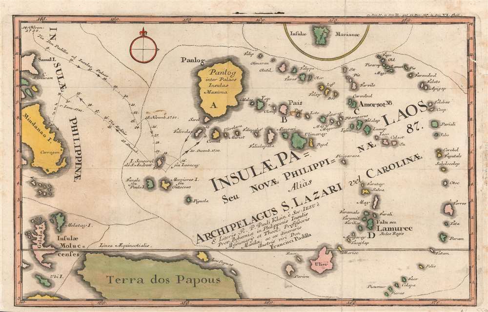
Insulae Palaos seu Novae Philippinae 87, alias Archipelagus S. Lazari vel Carolinae.
1726 (undated) 9 x 14 in (22.86 x 35.56 cm) 1 : 9000000
1726 (undated) 9 x 14 in (22.86 x 35.56 cm) 1 : 9000000
Description
A beautifully hand-colored 1726 Stöcklein map of Palau and surrounding islands in the southwestern Pacific. This map is a fascinating mash-up of Europeand and Indigenous cartography. It is an especially early presentation of these islands, based on a cartographic game of telephone from native Palauans waylaid in the Philippines through the Jesuits and then to the European public via Joseph Stöcklein.
Combining his own travels with information from his fellow Jesuit Paul Klein, Padilla produced the present map, which was published by Joseph Stöcklein in his important work Der Neue Weltbott that included descriptions and maps of distant lands visited by the Jesuits.
In 1696, the polymath Jesuit Paul Klein (also as Pablo Clain or Pauli Klain) met a group of Palauans on the Philippine island of Samar (here as 'Samal') who had been blown off course and landed there. After discussing their homeland with Klein, the Palauans set out a series of pebbles on a beach to draw a rough chart of the island chain and other nearby islands. Klein used this representation to develop a sketch map, adding inferences about islands' locations and distance from the Philippines, and included it with a letter to his Jesuit superiors in Rome, after which it became gradually known throughout Europe. Meanwhile, Spanish explorers were progressively discovering other islands in Micronesia, which combined with Klein's letter led to the islands garnering significant interest in Europe.
After three unsuccessful attempts, a Jesuit expedition led by Francisco Padilla reached Sonsorol, southwest of Babeldaob (here as 'Panlog'), the largest island in the chain, making them the first Europeans to intentionally travel to the islands. At Sonsorol, Padilla's group managed to interact with the natives (on canoes) and send a landing party ashore but was blown far out to sea and had to return to the Philippines without their confreres (who were never seen again). Thereafter, traveling to Palau and nearby islands remained difficult and dangerous for many years, leading to their being dubbed the Islas Encantadas.
Although it would be tempting to call this map 'inaccurate,' it would be more appropriate to see it as a combination of indigenous and European cartography. The Palauans who spoke to Klein clearly had a thorough understanding of the geography of the Carolinas that was perfectly suitable for their navigational purposes, as well as a means of representing or mapping such information, but that knowledge did not translate easily to developing European cartographic methods with standardized elements like scale, latitude, and longitude.
A Closer Look
Islands ranging from the southeastern part of the Philippines archipelago and New Guinea through the Caroline Islands are depicted, including Guam ('Guaham') at top. The course of a 1710 Jesuit expedition led by Francisco Padilla is tracked with its location at given dates. The dotted lines running throughout appear to separate out different groupings of islands.Combining his own travels with information from his fellow Jesuit Paul Klein, Padilla produced the present map, which was published by Joseph Stöcklein in his important work Der Neue Weltbott that included descriptions and maps of distant lands visited by the Jesuits.
Finding a Fabled Land
Although Spanish mariners and explorers occasionally were blown off course to some of the Caroline Islands closest to the Philippines, and some of these islands had even been claimed by Spai, European knowledge of the islands was extremely limited. Even when an island's existence was known through hearsay or inference, it was notoriously difficult to locate due to the generally small size of islands in the region and the difficulty of navigating the vast seas.In 1696, the polymath Jesuit Paul Klein (also as Pablo Clain or Pauli Klain) met a group of Palauans on the Philippine island of Samar (here as 'Samal') who had been blown off course and landed there. After discussing their homeland with Klein, the Palauans set out a series of pebbles on a beach to draw a rough chart of the island chain and other nearby islands. Klein used this representation to develop a sketch map, adding inferences about islands' locations and distance from the Philippines, and included it with a letter to his Jesuit superiors in Rome, after which it became gradually known throughout Europe. Meanwhile, Spanish explorers were progressively discovering other islands in Micronesia, which combined with Klein's letter led to the islands garnering significant interest in Europe.
After three unsuccessful attempts, a Jesuit expedition led by Francisco Padilla reached Sonsorol, southwest of Babeldaob (here as 'Panlog'), the largest island in the chain, making them the first Europeans to intentionally travel to the islands. At Sonsorol, Padilla's group managed to interact with the natives (on canoes) and send a landing party ashore but was blown far out to sea and had to return to the Philippines without their confreres (who were never seen again). Thereafter, traveling to Palau and nearby islands remained difficult and dangerous for many years, leading to their being dubbed the Islas Encantadas.
Cartographic Cobbling
In producing the present map, Padilla elaborated Klein's sketch and included information from his own voyage. However, the resulting map differs significantly from later maps of these islands. It lacks a consistent scale and the distances between islands are depicted as much less than they are in reality. The islands themselves are also misshapen, unsurprising as Europeans' knowledge of them still ultimately relied on the beach pebbles laid in front of Klein on Samar.Although it would be tempting to call this map 'inaccurate,' it would be more appropriate to see it as a combination of indigenous and European cartography. The Palauans who spoke to Klein clearly had a thorough understanding of the geography of the Carolinas that was perfectly suitable for their navigational purposes, as well as a means of representing or mapping such information, but that knowledge did not translate easily to developing European cartographic methods with standardized elements like scale, latitude, and longitude.
Publication History and Census
This map was originally drawn by Jesuit Fr. Paul Klein, based on the descriptions of the islands provided by the Palauans, and then elaborated by Francisco Padilla, as explained above. It appeared in Part IV of Josef Stöcklein's Der Neue Weltbott mit allerhand Nachrichten dern Missionariorum Societatis Jesu, published between 1728 and 1758 (the map itself is generally dated to 1726). This map is quite scarce, especially with such vibrant color; the OCLC only notes it among the holdings of one institution (the National Library of Australia), while Stöcklein's entire work is also very rare.Cartographer
Joseph Stöcklein [Stoecklein] (July 30, 1676 – December 28, 1733) was a Jesuit priest, missionary, and scholar active in the late 17th and early 18th centuries. He was born in Oettingen, Germany and joined the Jesuit order in Vienna around 1700. He served as a priest in military encampments where he became popular as a preacher. Afterwards he became the head of the Jesuit library in Graz, Switzerland, a position he maintained for six years. During this tenure he began work on his opus, the Welt-Bott, a vast compilation of Jesuit missionary letters and narratives translated into vernacular German intended both to glorify the priesthood and share valuable information about the world. Today this work is exceedingly rare. More by this mapmaker...
Source
Stocklein, J., Neuer Weltbott..., (Augsburg: Grätz) 1728.
Condition
Very good. Repaired tear at right towards top. Some discoloration to margins.
References
OCLC 224543746, 634492487.