This item has been sold, but you can get on the Waitlist to be notified if another example becomes available, or purchase a digital scan.
1844 Black Map of Palestine, Israel or the Holy Land
Palestine-black-1844$75.00

Title
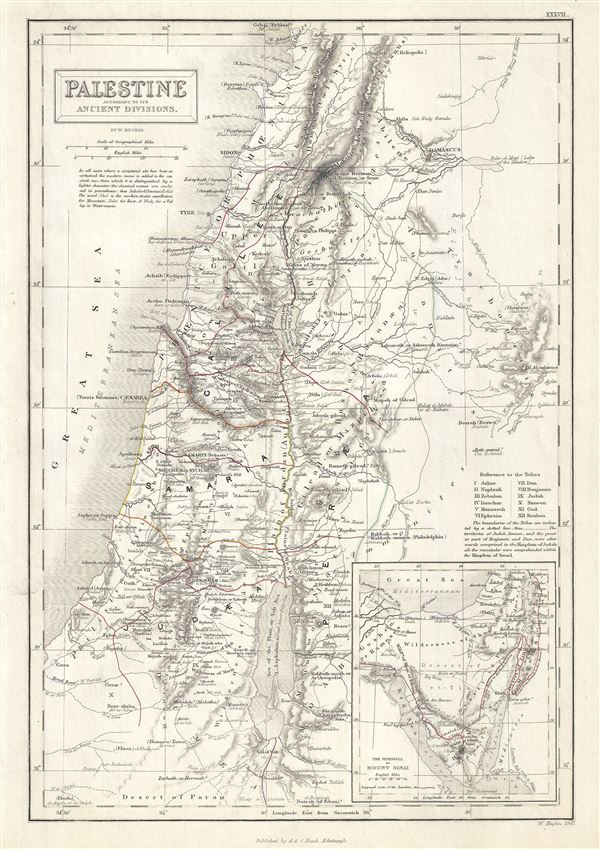
Palestine according to its Ancient Divisions.
1844 (undated) 15.5 x 11 in (39.37 x 27.94 cm) 1 : 990000
1844 (undated) 15.5 x 11 in (39.37 x 27.94 cm) 1 : 990000
Description
This is a scarce 1844 Adam and Charles Black map of Ancient Palestine, Israel or the Holy Land. It covers the region as it existed in Biblical times with divisions for each of the Twelve Tribes of Israel and includes the modern day nations of Israel, Palestine and Lebanon, as well as parts of adjacent Syria and Jordan. Various cities, towns, rivers, mountains and several other topographical details are noted with relief shown by hachure. This map marks both ancient and contemporary place names as well as the locations of Biblical events and ruined cities. The color coded outlines detail the region as it may have appeared in Biblical times, with the lands claimed by the various Tribes of Israel noted.
An inset map in the lower right quadrant details the Peninsula of Mount Sinai, where the cartographer notes, Mount Sinai, Mount Horeb, the ancient mountains of the Nile, and the Islamic Haj route. It shows the course of the Israelites as they fled out of Egypt, across the Red Sea, and subsequently spent the next forty years wandering in the Sinai before migrating into the Promised Land by crossing the Jordan River just north of the Dead Sea. The names of the Twelve Tribes are listed along the right margin. This map was engraved by William Hughes and issued as plate no. XXXVII in the 1844 edition of Black's General Atlas.
An inset map in the lower right quadrant details the Peninsula of Mount Sinai, where the cartographer notes, Mount Sinai, Mount Horeb, the ancient mountains of the Nile, and the Islamic Haj route. It shows the course of the Israelites as they fled out of Egypt, across the Red Sea, and subsequently spent the next forty years wandering in the Sinai before migrating into the Promised Land by crossing the Jordan River just north of the Dead Sea. The names of the Twelve Tribes are listed along the right margin. This map was engraved by William Hughes and issued as plate no. XXXVII in the 1844 edition of Black's General Atlas.
CartographerS
Charles and Adam Black (fl. 1807 - present) were map and book publishers based in Edinburgh. Charles and his uncle, Adam, both of Edinburgh, Scotland, founded their publishing firm in 1807. They published a series of maps and atlases throughout the 19th century. In addition to an array of atlases, the Black firm is known for their editions of the Encyclopedia Britannica (1817 - 1826) and the first publishing of Sir Walter Scott's novels in 1854. In 1889 the A. & C. Black publishing house moved to London where it remains in operation to this day. More by this mapmaker...
William Hughes (c. 1818 - May 21, 1876) was a cartographer, engraver, lithographer, printer, and publisher active in London during the middle part of the 19th century. Hughes enjoyed and long and varied cartographic career. He was elected a Fellow of the Royal Geographical Society in 1838 and, from about 1840, taught geography and mapmaking at St. Johns College for Civil Engineers. He later taught the same at both Queens College and Kings College, London. For a time he was employed as a map librarian for the British Museum. Hughes began engraving maps around 1839 and worked with most of the prominent British map and atlas publishers of his era, including but not limited to Charles Knight, A. and C. Black, George Philip, William Cassell, and others. Learn More...
Source
Black, A. and C., Black's General Atlas (Edinburgh), 1844.
Black's General Atlas was a popular Scottish atlas of the world issued by the Edinburgh firm of Adam and Charles Black. This atlas was first issued in 1840 with subsequent editions being printed well into the 1890s. While most editions were printed in Edinburgh, an American edition was issued in 1857. Most early editions of his atlas were engraved by S. Hall. Typically this refers to Sidney Hall, who died in 1831, but in this case, since the engraving was initiated well after his death, it was most likely his widow, Selina Hall, who did the engraving. Later editions feature additional maps updated and engraved by William Hughes. Early editions featured outline color only, but later editions embraced a full color approach with pale green, yellow, and blue pastels. All editions are known for their meticulous presentation of the most up-to-date cartographic information. Moreover, this exceptionally long publication run provides a fine cartographic record of the middle to late 19th century - particularly as regards the complex cartographic evolution of the Americas through this period.
Condition
Very good. Original platemark visible. Blank on verso.
References
Rumsey 2305.042 (1854 edition). Philips (atlases) 4334.