This item has been sold, but you can get on the Waitlist to be notified if another example becomes available, or purchase a digital scan.
1851 Black Map of Ancient Palestine, Israel or Holyland (12 Tribes)
Palestine-black-1851$75.00

Title
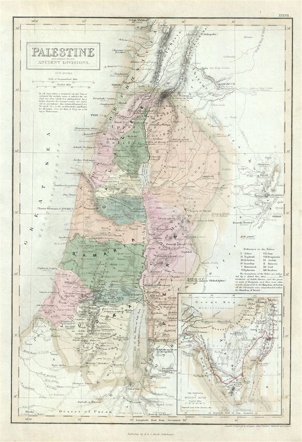
Palestine according to its Ancient Divisions.
1851 (undated) 16 x 11 in (40.64 x 27.94 cm)
1851 (undated) 16 x 11 in (40.64 x 27.94 cm)
Description
This is a fine example of the Adam and Charles Black's 1851 map of Ancient Palestine, Israel or the Holy Land. It covers the region as it existed in Biblical times with divisions for each of the Twelve Tribes of Israel and includes the modern day nations of Israel, Palestine and Lebanon, as well as parts of adjacent Syria and Jordan. This map marks both ancient and contemporary place names as well as the locations of Biblical events and ruined cities. The color coding details the region as it may have appeared in Biblical times, with the lands claimed by the various Tribes of Israel noted. An inset map in the lower right quadrant details the Peninsula of Mount Sinai, where the cartographer notes, Mount Sinai, Mount Horeb, the ancient mountains of the Nile, and the Islamic Haj route. The names of the Twelve Tribes are listed along the right the right margin. Various cities, towns, rivers, mountains and several other topographical details are noted with relief shown in hachures. This map was engraved by William Huges and issued as plate no. XXXVII in the 1851 edition of Black's General Atlas of the World.
CartographerS
Charles and Adam Black (fl. 1807 - present) were map and book publishers based in Edinburgh. Charles and his uncle, Adam, both of Edinburgh, Scotland, founded their publishing firm in 1807. They published a series of maps and atlases throughout the 19th century. In addition to an array of atlases, the Black firm is known for their editions of the Encyclopedia Britannica (1817 - 1826) and the first publishing of Sir Walter Scott's novels in 1854. In 1889 the A. & C. Black publishing house moved to London where it remains in operation to this day. More by this mapmaker...
William Hughes (c. 1818 - May 21, 1876) was a cartographer, engraver, lithographer, printer, and publisher active in London during the middle part of the 19th century. Hughes enjoyed and long and varied cartographic career. He was elected a Fellow of the Royal Geographical Society in 1838 and, from about 1840, taught geography and mapmaking at St. Johns College for Civil Engineers. He later taught the same at both Queens College and Kings College, London. For a time he was employed as a map librarian for the British Museum. Hughes began engraving maps around 1839 and worked with most of the prominent British map and atlas publishers of his era, including but not limited to Charles Knight, A. and C. Black, George Philip, William Cassell, and others. Learn More...
Source
Black, A. and C., General Atlas Of The World, (Edinburgh) 1851.
Condition
Very good. Minor overall toning. Blank on verso.
References
Rumsey 2305.042 (1854 edition). Philips (atlases) 4334.