This item has been sold, but you can get on the Waitlist to be notified if another example becomes available, or purchase a digital scan.
1832 Burr Map of Palestine, Israel or the Holy Land
Palestine-burr-1835$100.00

Title
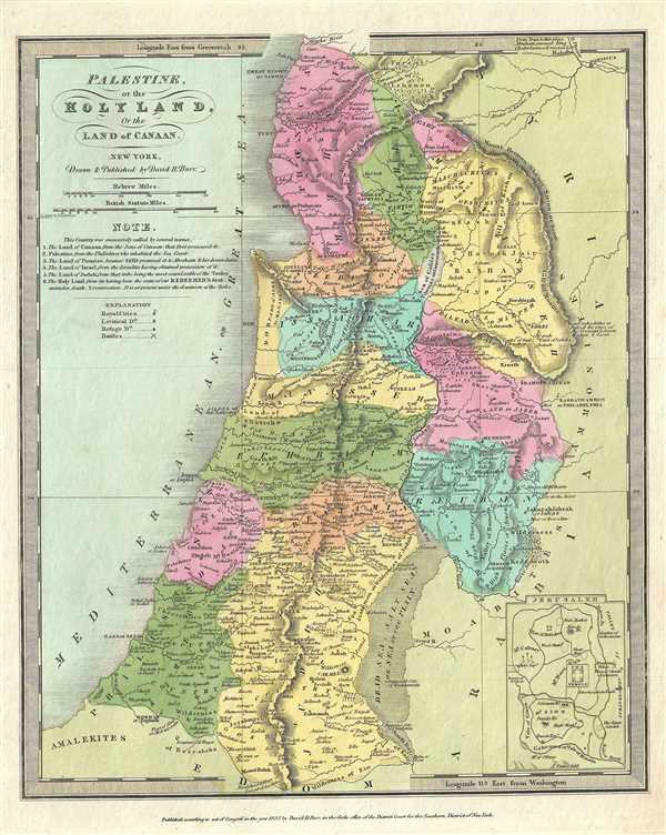
Palestine, or the Holy Land, Or the Land of Canaan.
1832 (dated) 14 x 11 in (35.56 x 27.94 cm) 1 : 950400
1832 (dated) 14 x 11 in (35.56 x 27.94 cm) 1 : 950400
Description
This is an interesting 1832 example of the 1832 first edition map of Israel, Palestine or the Holy Land by David H. Burr. It covers the region from Sidon south to the southern tip of the Dead Sea and includes the modern day nations of Israel, Lebanon and Palestine as well as parts of Jordan and Syria. The regions claimed by the various tribes of Israel are noted by color-coding. The map identifies numerous cities, river systems, historical sites, battlegrounds, and mountain ranges. A note under the title lists the various names by which this region has been called. An inset of Jerusalem in included in the lower right quadrant.
Burr prepared this map in the waning years of the Ottoman Empire whose influence, though rapidly declining, still held sway over much of the Middle East. In 1832, Palestine was conquered by Muhammad Ali's Egypt following the Egyptian-Ottoman War. British intervention returned control of Palestine to the Ottoman rulers in 1840, which lasted until World War I.
According to Ristow, although Burr is credited on the title page, he left this atlas incomplete. He was appointed as topographer to the U.S. Post Office, and of the sixty-three maps finally included in this atlas, only completed eight. The rest of the maps were then completed by Illman and Pilbrow in Burr's style. This map was ‘Entered according to act of Congress in the year 1832 by David H. Burr in the Clerk’s office of the District Court for the Southern District of New York’, but was not published until the atlas was released in 1835. Published by D. S. Stone in Burr’s New Universal Atlas.
Cartographer
David Hugh Burr (August 18, 1803 - December 25, 1875) of one of the first and most important truly American cartographers and map publishers. Burr was born in Bridgeport Connecticut in August of 1803. In 1822 Burr moved to Kingsboro, New York to study law. A year and a half later he was admitted to the New York Bar association. Burr must have questioned his choice of careers because shortly after being admitted to the Bar, he joined the New York State Militia. Though largely untrained in the art of surveying, Burr was assigned to work under Surveyor General of New York, Simeon De Witt, to survey several New York Roadways. Seeing a window of opportunity, Burr was able to negotiate with the governor of New York at the time, De Witt Clinton, to obtain copies of other New York survey work in order to compile a map and Atlas of the state of New York. Recognizing the need for quality survey work of its territory, the government of New York heartily endorsed and financed Burr's efforts. The resulting 1829 Atlas of the State of New York was the second atlas of an individual U.S. state and one of the most important state atlases ever produced. Burr went on to issue other maps both of New York and of the United States in general. In cooperation with publishing firm of Illman & Pillbrow, he produced an important New Universal Atlas and, with J.H. Colton, several very important maps of New York City. In recognition of this work, Burr was appointed both "Topographer to the Post office" and "Geographer to the House of Representatives of the United States". Later, in 1855, Burr was assigned to the newly created position of Surveyor General to the State of Utah. Burr retired from the position and from cartographic work in general in 1857 when light of some of his financial misdeeds and frauds came to light. He was accused of submitting false expense reports and underpaying employees, among other indiscretions. More by this mapmaker...
Source
Burr, David H., A New Universal Atlas; Comprising Separate Maps of All the Principal Empires, Kingdoms & States Throughout the World: and forming a distinct Atlas of the United States, (New York: D. S. Stone) 1835 (First Edition).
Burr's New Universal Atlas was first published in 1835. It is one of the first great American commercial atlases and one of the most important to appear before the Civil War. Burr was most likely initially inspired to publish a 'universal atlas' in pursuit a more general audience by the success of his 1829 Atlas of New York State. He began work on the Universal Atlas sometime around 1830. By 1832 he had copyrighted eight new maps for the work. Around this time he accepted a position as topographer and cartographer for the United States Postal Department and was thus unable to finish the atlas personally. Instead, while retaining editing rights and overall ownership, Burr passed much of the production work to his engravers Thomas Illman and Edward Pillbrow. The first edition of the atlas was completed in 1835 and published by D. S. Stone of New York. A second edition, published by William Hall, appeared in the following year, 1836. Both editions featured 63 maps, the first part of the book being dedicated to world maps and the second part to the Americas, particularly the United States. Some of the 1836 editions feature outline rather than the distinctive full color common in the first edition. The plates for the atlas were later sold to Jeremiah Greenleaf who expanded the atlas to 65 maps and issued editions in 1840, 1842, and 1848.
Condition
Very good. Minor foxing. Original platemark visible.
References
Rumsey 4628.022. Philips (Atlases) 771.