This item has been sold, but you can get on the Waitlist to be notified if another example becomes available, or purchase a digital scan.
1945 Sundberg Map of Palestine / Israel / Holy Land
Palestine-sundberg-1945$225.00

Title
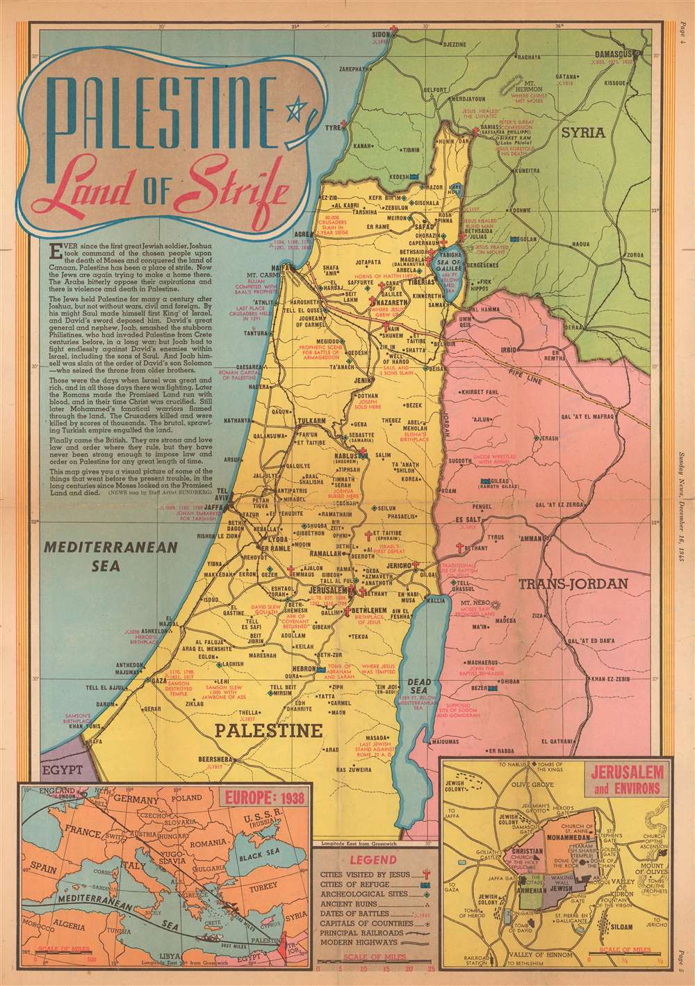
Palestine Land of Strife.
1945 (dated) 21 x 15 in (53.34 x 38.1 cm) 1 : 704000
1945 (dated) 21 x 15 in (53.34 x 38.1 cm) 1 : 704000
Description
This is a 1945 Edwin Sundberg map of Palestine. The map depicts the region from Sidon to the Dead Sea and from the Mediterranean to Damascus. Throughout the region, cities and towns are labeled, and modern highways connect many of the major population centers. Red text marks important locations in Biblical history and battles fought in the region during the Crusades and World War I. Crosses mark cities visited by Jesus. An inset in the lower right corner details Jerusalem and its environs, including the divisions of the Old City. A second inset on the lower left illustrates Europe in 1938, the year before Adolf Hitler and Nazi Germany invaded Poland and ignited World War II.
Palestine in 1945
At the end of 1945, after World War II, the British, who had been governing Mandatory Palestine since 1945, found themselves fighting a Jewish guerrilla campaign. Angered over Jewish immigration limits, the Jews living in Palestine warred with the British governors and the Arab community over their desire to allow Jewish Holocaust survivors entry into Palestine. After years of fighting a guerrilla war, in which hundreds of British soldiers and people of other nationalities perished at the insurgents' hands, the British cabinet declared that the mandate was no longer tenable in September 1947 and began withdrawing their troops. The day before the expiration of the British Mandate, May 14, 1948, David Ben-Gurion declared the establishment of the Jewish state of Eretz-Israel.Publication History and Census
This map was drawn by Edwin Sundberg and published in the December 16, 1945 edition of the Sunday News. Even though Sundberg's works were produced for a New York City newspaper, his maps appear to have survived poorly, and are scarce on the market today. We are aware of only one other known example of the present map, which is in a private collection.Cartographer
Edwin L. Sundberg (1898 - 1978) was an American cartographer known for his pictorial pieces. Sundberg was a staff artist for the Sunday News in New York City and eventually became Chief Cartographer in charge of a small staff of artists. More by this mapmaker...
Condition
Very good. Newsprint. Light wear and toning along original fold lines. Closed margin tears and fold separations professionally repaired on verso. Text and printed photographs on verso.