This item has been sold, but you can get on the Waitlist to be notified if another example becomes available, or purchase a digital scan.
1836 Tanner Map of Palestine - Israel - Holy Land
Palestine-tanner-1836$100.00

Title
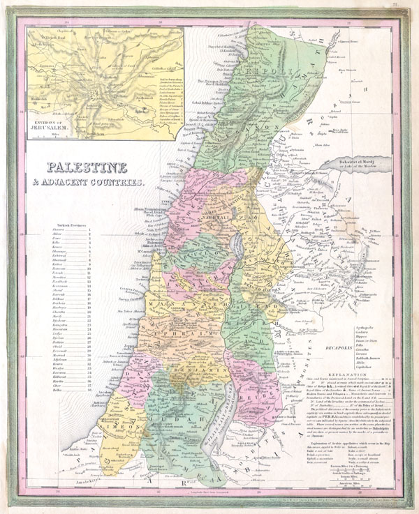
Palestine & Adjacent Countries.
1836 12 x 15.5 in (30.48 x 39.37 cm)
1836 12 x 15.5 in (30.48 x 39.37 cm)
Description
A fine and rare 1836 S. A. Mitchell map depicting Palestine, Israel or the Holy Land. Includes From Gaza North as far as modern day Lebanon. The regions claimed by the various tribes of Israel are noted. In the upper right there is an inset map of the Environs of Jerusalem. Specifically notes cities and towns mentioned in the Bible as well as marks Cities of Refuge, Levitical Cities, and Royal Cities of the Israelites. Ruins are also noted. Dated and copyrighted: 'Entered according to the Act o Congress in the year of 1836 by H. S. Tanner in the Clerk's office of the District Court of The Eastern District of Pennsylvania.'
Cartographer
Samuel Augustus Mitchell (March 20, 1792 - December 20, 1868) began his map publishing career in the early 1830s. Mitchell was born in Bristol, Connecticut. He relocated to Philadelphia in 1821. Having worked as a school teacher and a geographical writer, Mitchell was frustrated with the low quality and inaccuracy of school texts of the period. His first maps were an attempt to rectify this problem. In the next 20 years Mitchell would become the most prominent American map publisher of the mid-19th century. Mitchell worked with prominent engravers J. H. Young, H. S. Tanner, and H. N. Burroughs before attaining the full copyright on his maps in 1847. In 1849 Mitchell either partnered with or sold his plates to Thomas, Cowperthwait and Company who continued to publish the Mitchell's Universal Atlas. By about 1856 most of the Mitchell plates and copyrights were acquired by Charles Desilver who continued to publish the maps, many with modified borders and color schemes, until Mitchell's son, Samuel Augustus Mitchell Junior, entered the picture. In 1859, S.A. Mitchell Jr. purchased most of the plates back from Desilver and introduced his own floral motif border. From 1860 on, he published his own editions of the New General Atlas. The younger Mitchell became as prominent as his father, publishing maps and atlases until 1887, when most of the copyrights were again sold and the Mitchell firm closed its doors for the final time. More by this mapmaker...
Condition
Very good condition. Blank on verso.