1836 Belmas / Tardieu Map of Pamplona, Spain During the Napoleonic Wars
Pamplune-belmastardieu-1836$600.00


Title
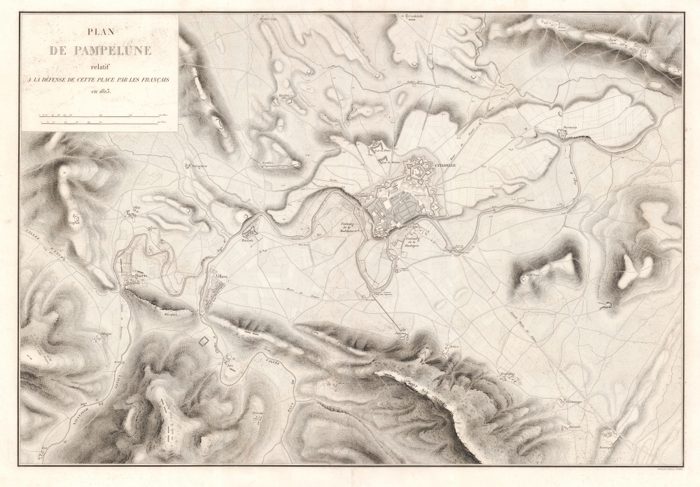
Plan de Pampelune relatif à la Défense de Cette Place par les Français en 1813.
1836 (dated) 25 x 34.75 in (63.5 x 88.265 cm) 1 : 9500
1836 (dated) 25 x 34.75 in (63.5 x 88.265 cm) 1 : 9500
Description
This is an 1836 Jacques-Vital Belmas city plan or map of Pamplona, Spain, during the 1813 Siege of Pamplona, one of the battles in the larger Peninsular War (1808 - 1814). The besieged French forces managed to hold out for over four months, delaying Wellington's advance into France, since he refused to move into France until after Pamplona had fallen. The result of meticulous military surveys, this is one of the best large-format maps of Pamplona to appear in the early 19th century.
A Closer Look
Pamplona's citadel appears in detail connect to the larger city walls. Streets are illustrated within the walled city along with the esplanade and the city gates. Two forts appear above the city to the left of the citadel. The city's environs are illustrated in detail. Buildings and streets appear within walled towns and unwalled villages, while rivers meander through the countryside providing natural fortifications. The positions of English and French soldiers appear along the bottom border, with English forces holding the high ground.Siege of Pamplona (June 26 - October 31, 1813)
The Siege of Pamplona was part of the Peninsular War, fought by the invading First French Empire agaisnt Spain, Portugal, and the United Kingdom between May 2, 1808 - April 17, 1814. It was part of the larger Napoleonic Wars (May 18, 1803 - November 20, 1815). The siege began on June 26, 1813, after the decisive June 21st Battle of Vitoria, a rare victory over the French by an English-led coalition under the future Duke of Wellington. Following the battle, Wellington pursued the retreating French in addition to detaching 10,000 men to lay siege to Pamplona, where 3,800 French troops were garrisoned. French forces tried to relieve their besieged comrades in late July but were repulsed. The French in Pamplona, having run out of supplies, surrendered on October 31 with roughly 500 killed, 899 wounded, and 2,150 captured.Publication History and Census
This map was engraved by Ambroise Tardieu for inclusion in Jacques-Vital Belmas's (1792 - 1864) Journaux des siéges faits ou soutenus par les Français dans la Péninsule, de 1807 à 1814. We note one cataloged example of the separate map, at at the Bibliothèque nationale de France. The book and the accompanying atlas are however, well represented in institutional collections.CartographerS
Jacques-Vital Belmas (1792 - 1864) was a French colonel and military writer. He is the author of an atlas entitled Journaux des siéges faits ou soutenus par les Français dans la Péninsule, de 1807 à 1814. More by this mapmaker...
Ambroise Tardieu (March 2, 1788 - January 17, 1841) was a prominent French cartographer and engraver operating in the late 18th and early 19th centuries. He was member of the large and prolific Tardieu family, which, for over 200 years, produced multiple skilled and active engravers. Tardieu's work is known for its beauty and accuracy as well as for its depth of detail. Tardieu's most important work is his version of John Arrowsmith's large format map of the United States, published in 1806. Ambroise Tardieu is eclipsed in fame by his son, artist and medical scholar, August Ambroise Tardieu. Ambroise Tardieu is also frequently confused with Jean Baptiste Pierre Tardieu, another unrelated French map and print engraver active in the early 19th century. Learn More...
Source
Belmas, J-V., Journaux des siéges faits ou soutenus par les Français dans la Péninsule, de 1807 à 1814, (Paris: Firmin Didot Frères et Cie.) 1836.
Condition
Very good. Light wear along original centerfold. Closed margin tears professionally repaired on verso.
References
OCLC 762920532.