This item has been sold, but you can get on the Waitlist to be notified if another example becomes available, or purchase a digital scan.
1913 Rand McNally Map of Panama, Panama Canal
Panama-randmcnally-1913$475.00

Title
The Rand-McNally new library atlas map of Panama.
1913 (dated) 18.5 x 27.25 in (46.99 x 69.215 cm) 1 : 1045000
1913 (dated) 18.5 x 27.25 in (46.99 x 69.215 cm) 1 : 1045000
Description
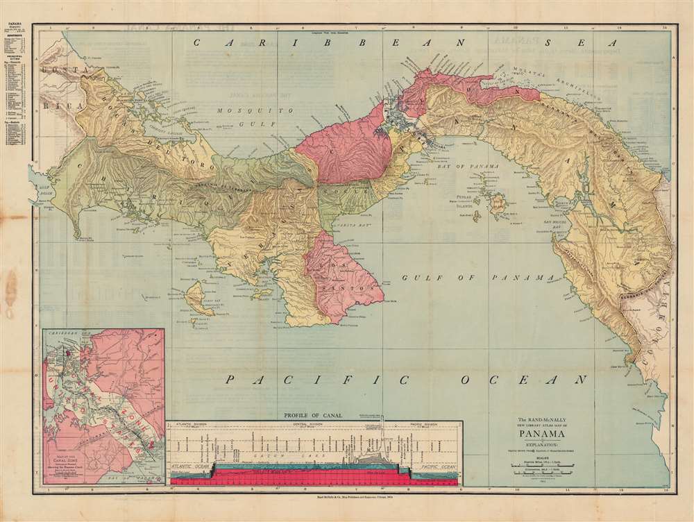
This is a beautiful 1913 Rand McNally map of Panama, highlighting the Panama Canal, which was completed around the time of publication. The map gives some sense of the incredible difficulties that had to be overcome in the construction of the canal, and the means employed.
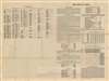
At bottom is a striking diagram showing the canal in profile, including areas excavated by the aborted French project to dig the canal (discussed below) and completed by the later American effort. The greatest challenge was carving a path through the mountains of the Continental Divide on the southern, Pacific side of the canal, what became the Culebra Cut, known for many years as the Gaillard Cut after the leading U.S. Army engineer on the project.
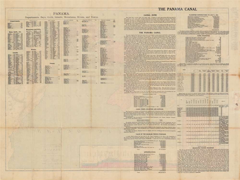
The verso contains a detailed explanation of the canal's depth, structure, and operation, as well as statistics on the cost of the canal, distances from the canal to various ports, time saved in travel between ports thanks to the canal, and other figures.
The first proper attempt to build an interoceanic canal was the vision of the French diplomat Ferdinand de Lesseps. Lesseps had been successful in the excavation of the Suez Canal and saw the construction of Panama Canal as a grander, more lucrative, next project. He incorporated the Compagnie Universelle du Canal Interoceanique on March 3, 1881, which purchased a controlling stake in the existing railroad. Unprepared for the jungle climate, all progress was soon mired by disease, poor planning, political posturing, fraud, and bankruptcy. The Compagnie Universelle du Canal Interoceanique was dissolved by a French bankruptcy court on February 4, of 1889, a development that became a major political scandal, in large part because many French legislators had been investors in the company.
Five years later, in 1894, the company's assets were reorganized under new investors as Compagnie Nouvelle du Canal de Panama. This organization immediately began new plans to resume excavations, including producing detailed new maps of the project. Ultimately, the French lost control of the canal project to the United States. In 1903, the Hay-Bunau-Varilla Treaty between Panama and the United States granted the U.S. canal-building rights and the sole right to operate and control the Canal Zone. The Compagnie Nouvelle du Canal de Panama sold its holdings (including the railroad) to the United States in 1904, supplanting an earlier failed American venture to build a canal in Nicaragua, and the Panama Canal officially opened under U.S. Management ten years later in 1914.
Although the canal was an engineering marvel several decades in the making, its opening was marred by the outbreak of the First World War. The high death rate of workers (most of whom were from the Caribbean), especially from yellow fever and malaria, also casts a pall over the success of its construction. Still, the canal drastically cut travel times between the Pacific and Atlantic, was a major asset to the Allies during World War II, and has helped Panama to become the wealthiest country in Central America on a per capita basis. The Canal Zone remained a U.S. territory until the 1977 Torrijos-Carter Treaty began a gradual return of the territory to Panamanian sovereignty and management, a process completed in 2000. After coming under full Panamanian control, a third and wider lane of locks was constructed and opened in 2016, allowing larger 'Panamax' container ships to transit the canal.
A Closer Look
The map shows the Republic of Panama with provinces and the Canal Zone color-coded for quick identification. It includes Rand-McNally's characteristic extensive index of administrative units and geographic features, which begins in the left-hand margin and continues on the verso (back). An inset at bottom-left shows the Canal Zone and carve outs in the zone for Colon and Panama City (though the U.S. did retain the right to intervene in the administration of these cities in certain cases, as explained on the verso).At bottom is a striking diagram showing the canal in profile, including areas excavated by the aborted French project to dig the canal (discussed below) and completed by the later American effort. The greatest challenge was carving a path through the mountains of the Continental Divide on the southern, Pacific side of the canal, what became the Culebra Cut, known for many years as the Gaillard Cut after the leading U.S. Army engineer on the project.
The verso contains a detailed explanation of the canal's depth, structure, and operation, as well as statistics on the cost of the canal, distances from the canal to various ports, time saved in travel between ports thanks to the canal, and other figures.
Panama Canal
The potential for bridging the narrow isthmus of Panama to link the Pacific and Atlantic Oceans had been conceived long before the completion of the canal, but the hurdles standing in the way of such a connection were formidable, including dense jungle, mountains, and tropical diseases. The first major link across the isthmus was the Panama Railroad, built by a group of American investors in the early 1850s to facilitate the California Gold Rush.The first proper attempt to build an interoceanic canal was the vision of the French diplomat Ferdinand de Lesseps. Lesseps had been successful in the excavation of the Suez Canal and saw the construction of Panama Canal as a grander, more lucrative, next project. He incorporated the Compagnie Universelle du Canal Interoceanique on March 3, 1881, which purchased a controlling stake in the existing railroad. Unprepared for the jungle climate, all progress was soon mired by disease, poor planning, political posturing, fraud, and bankruptcy. The Compagnie Universelle du Canal Interoceanique was dissolved by a French bankruptcy court on February 4, of 1889, a development that became a major political scandal, in large part because many French legislators had been investors in the company.
Five years later, in 1894, the company's assets were reorganized under new investors as Compagnie Nouvelle du Canal de Panama. This organization immediately began new plans to resume excavations, including producing detailed new maps of the project. Ultimately, the French lost control of the canal project to the United States. In 1903, the Hay-Bunau-Varilla Treaty between Panama and the United States granted the U.S. canal-building rights and the sole right to operate and control the Canal Zone. The Compagnie Nouvelle du Canal de Panama sold its holdings (including the railroad) to the United States in 1904, supplanting an earlier failed American venture to build a canal in Nicaragua, and the Panama Canal officially opened under U.S. Management ten years later in 1914.
Although the canal was an engineering marvel several decades in the making, its opening was marred by the outbreak of the First World War. The high death rate of workers (most of whom were from the Caribbean), especially from yellow fever and malaria, also casts a pall over the success of its construction. Still, the canal drastically cut travel times between the Pacific and Atlantic, was a major asset to the Allies during World War II, and has helped Panama to become the wealthiest country in Central America on a per capita basis. The Canal Zone remained a U.S. territory until the 1977 Torrijos-Carter Treaty began a gradual return of the territory to Panamanian sovereignty and management, a process completed in 2000. After coming under full Panamanian control, a third and wider lane of locks was constructed and opened in 2016, allowing larger 'Panamax' container ships to transit the canal.
Publication History and Census
This map was made by Rand McNally in 1913 (despite the 1914 copyright at bottom). A similar map was published in the The Rand-McNally New Library Atlas of that year, but this example is an especially rare separate issue publication. It is cataloged as being held by Harvard and Princeton Universities and is scarce to the market.Cartographer
Rand, McNally and Co. (fl. 1856 - present) is an American publisher of maps, atlases and globes. The company was founded in 1856 when William H. Rand, a native of Quincy, Massachusetts, opened a print shop in Chicago. Rand hired the recent Irish immigrant Andrew McNally to assist in the shop giving him a wage of 9 USD per week. The duo landed several important contracts, including the Tribune's (later renamed the Chicago Tribune) printing operation. In 1872, Rand McNally produced its first map, a railroad guide, using a new cost effective printing technique known as wax process engraving. As Chicago developed as a railway hub, the Rand firm, now incorporated as Rand McNally, began producing a wide array of railroad maps and guides. Over time, the firm expanded into atlases, globes, educational material, and general literature. By embracing the wax engraving process, Rand McNally was able to dominate the map and atlas market, pushing more traditional American lithographic publishers like Colton, Johnson, and Mitchell out of business. Eventually Rand McNally opened an annex office in New York City headed by Caleb S. Hammond, whose name is today synonymous with maps and atlases, and who later started his own map company, C. S. Hammond & Co. Both firms remain in business. More by this mapmaker...
Condition
Good. Original fold lines visible. Discoloration and imperfections in the left-hand margin and sporadically elsewhere.
References
Rumsey 2790.305, OCLC 1253301843.