This item has been sold, but you can get on the Waitlist to be notified if another example becomes available, or purchase a digital scan.
1911 Gray View of the Panama Canal
PanamaCanal-gray-1911$250.00


Title
Aeronautical View of the Panama Canal.
1911 (dated) 9.5 x 13.5 in (24.13 x 34.29 cm) 1 : 250000
1911 (dated) 9.5 x 13.5 in (24.13 x 34.29 cm) 1 : 250000
Description
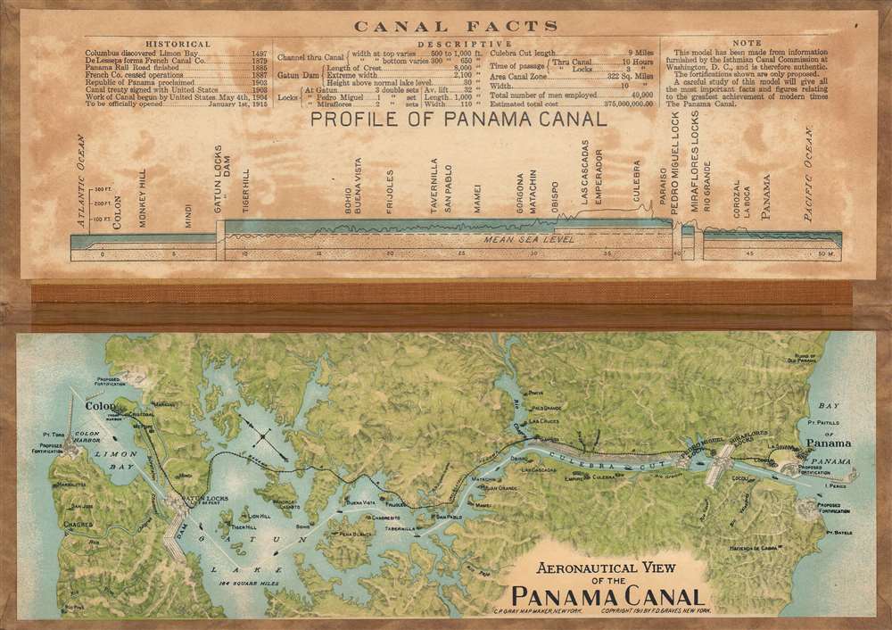
This is a curious 1911 raised relief view of the Panama Canal by C.P. Gray and F.D. Graves. It demonstrates some of the incredible challenges facing canal engineers as well as the enthusiasm for the canal among the public as it neared completion.
The greatest challenge (among many) in constructing the canal was carving a path through the mountains of the Continental Divide on the southern, Pacific side of the canal. This portion of the canal became the Culebra Cut, known for many years as the Gaillard Cut after the leading U.S. Army engineer on the project, which is followed immediately by the Pedro Miguel and Miraflores Locks (in recent years, a third set of locks was added at Cocoli).
The top also includes important historical dates and information about the canal, including the planned opening date of January 1, 1915 (in the event, it opened several months earlier). The map shows proposed fortifications, most of which were eventually built, though not completed until the 1930s. They have since been decommissioned as the Canal Zone returned to Panamanian sovereignty and have been repurposed for civilian use.
The first proper attempt to build an interoceanic canal was the vision of the French diplomat Ferdinand de Lesseps. Lesseps had been successful in the excavation of the Suez Canal and saw the construction of Panama Canal as a grander, more lucrative, next project. He incorporated the Compagnie Universelle du Canal Interoceanique on March 3, 1881, which purchased a controlling stake in the existing railroad. Unprepared for the jungle climate, all progress was soon mired by disease, poor planning, political posturing, fraud, and bankruptcy. The Compagnie Universelle du Canal Interoceanique was dissolved by a French bankruptcy court on February 4, of 1889, a development that became a major political scandal, in large part because many French legislators had been investors in the company.
Five years later, in 1894, the company's assets were reorganized under new investors as Compagnie Nouvelle du Canal de Panama. This organization immediately began new plans to resume excavations, including producing detailed new maps of the project. Ultimately, the French lost control of the canal project to the United States. In 1903, the Hay-Bunau-Varilla Treaty between Panama and the United States granted the U.S. canal-building rights and the sole right to operate and control the Canal Zone. The Compagnie Nouvelle du Canal de Panama sold its holdings (including the railroad) to the United States in 1904, supplanting an earlier failed American venture to build a canal in Nicaragua, and the Panama Canal officially opened under U.S. Management ten years later in 1914.
Although the canal was an engineering marvel several decades in the making, its opening was marred by the outbreak of the First World War. The high death rate of workers (most of whom were from the Caribbean), especially from yellow fever and malaria, also casts a pall over the success of its construction. Still, the canal drastically cut travel times between the Pacific and Atlantic, was a major asset to the Allies during World War II, and has helped Panama to become the wealthiest country in Central America on a per capita basis.
The Canal Zone remained a U.S. territory until the 1977 Torrijos-Carter Treaty began a gradual return of the territory to Panamanian sovereignty and management, a process completed in 2000. After coming under full Panamanian control, a third and wider lane of locks was constructed and opened in 2016, allowing larger 'Panamax' container ships to transit the canal.
A Closer Look
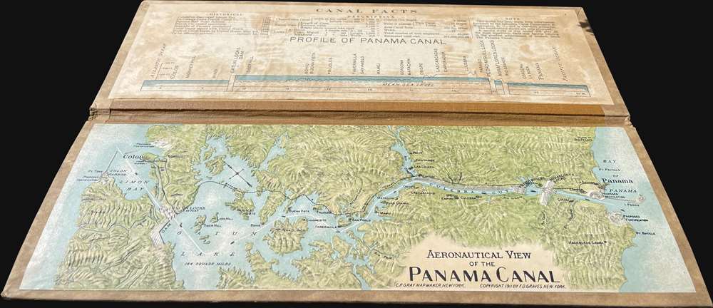
This is a pressed cardboard raised relief model, a visually gripping and memorable choice of medium. It shows an overhead view of the Canal Zone oriented towards the northeast, with the Atlantic side at left and the Pacific side at right. At top is a diagram showing the canal in profile.The greatest challenge (among many) in constructing the canal was carving a path through the mountains of the Continental Divide on the southern, Pacific side of the canal. This portion of the canal became the Culebra Cut, known for many years as the Gaillard Cut after the leading U.S. Army engineer on the project, which is followed immediately by the Pedro Miguel and Miraflores Locks (in recent years, a third set of locks was added at Cocoli).
The top also includes important historical dates and information about the canal, including the planned opening date of January 1, 1915 (in the event, it opened several months earlier). The map shows proposed fortifications, most of which were eventually built, though not completed until the 1930s. They have since been decommissioned as the Canal Zone returned to Panamanian sovereignty and have been repurposed for civilian use.
Panama Canal
The potential for bridging the narrow isthmus of Panama to link the Pacific and Atlantic Oceans had been conceived long before the completion of the canal, but the hurdles standing in the way of such a connection were formidable, including dense jungle, mountains, and tropical diseases. The first major link across the isthmus was the Panama Railroad, built by a group of American investors in the early 1850s to facilitate the California Gold Rush.The first proper attempt to build an interoceanic canal was the vision of the French diplomat Ferdinand de Lesseps. Lesseps had been successful in the excavation of the Suez Canal and saw the construction of Panama Canal as a grander, more lucrative, next project. He incorporated the Compagnie Universelle du Canal Interoceanique on March 3, 1881, which purchased a controlling stake in the existing railroad. Unprepared for the jungle climate, all progress was soon mired by disease, poor planning, political posturing, fraud, and bankruptcy. The Compagnie Universelle du Canal Interoceanique was dissolved by a French bankruptcy court on February 4, of 1889, a development that became a major political scandal, in large part because many French legislators had been investors in the company.
Five years later, in 1894, the company's assets were reorganized under new investors as Compagnie Nouvelle du Canal de Panama. This organization immediately began new plans to resume excavations, including producing detailed new maps of the project. Ultimately, the French lost control of the canal project to the United States. In 1903, the Hay-Bunau-Varilla Treaty between Panama and the United States granted the U.S. canal-building rights and the sole right to operate and control the Canal Zone. The Compagnie Nouvelle du Canal de Panama sold its holdings (including the railroad) to the United States in 1904, supplanting an earlier failed American venture to build a canal in Nicaragua, and the Panama Canal officially opened under U.S. Management ten years later in 1914.
Although the canal was an engineering marvel several decades in the making, its opening was marred by the outbreak of the First World War. The high death rate of workers (most of whom were from the Caribbean), especially from yellow fever and malaria, also casts a pall over the success of its construction. Still, the canal drastically cut travel times between the Pacific and Atlantic, was a major asset to the Allies during World War II, and has helped Panama to become the wealthiest country in Central America on a per capita basis.
The Canal Zone remained a U.S. territory until the 1977 Torrijos-Carter Treaty began a gradual return of the territory to Panamanian sovereignty and management, a process completed in 2000. After coming under full Panamanian control, a third and wider lane of locks was constructed and opened in 2016, allowing larger 'Panamax' container ships to transit the canal.
Publication History and Census
This map was drawn by C.P. Gray and is copyrighted by F.D. Graves (no further information is available on this individual). The same view is also sometimes cataloged as having been published by the Central Novelty Company, though the name does not appear here. The outside cover lists J.L. Hammett Company (a purveyor of school supplies that is still in operation). Other examples of the map have 'Compliments of the Hamburg-American Line' or 'Chas. A. Schieren Company' (tanners and belt manufacturers) on the outside cover, suggesting that Gray and Graves sold the map widely for distribution and used the opportunity to make additional money from advertising. Due to inconsistencies in cataloging, the precise distribution of this map is difficult to determine, but it is known by us to be held by a handful of academic institutions in the United States.Cartographer
C.P. Gray (fl. c. 1879 - 1920) was an artist and cartographer who specialized in maps of railroads, canals, ports, and mines. He also produced maps of New York City and Mexico, and was involved in the production of several editions of Cram's unrivaled atlas of the world in the 1890s. More by this mapmaker...
Condition
Very good.
References
Boston Public Library, Leventhal, G4872.P3C18 1911 .G73, OCLC 68698627, 654679997, 760184280, 1316716373.