This item has been sold, but you can get on the Waitlist to be notified if another example becomes available, or purchase a digital scan.
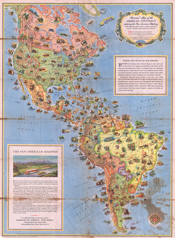
1930 Pictorial Map of North America and South America
PanAmericanHighway-standardoil-1930$100.00

Title
Pictorial Map of the American Continent Following the Pan American Highway
c. 1930 (undated) 24 x 18 in (60.96 x 45.72 cm)
c. 1930 (undated) 24 x 18 in (60.96 x 45.72 cm)
Description
This is a very attractive and beautifully illustrated c. 1930 pictorial map of North America and South America drawn to illustrate the Pan-American Highway. The Pan-American Highway is a network of roads measuring about 29,800 miles in length. Except for an 87 kilometers 54 mile rainforest break, called the Darién Gap, the road links the mainland nations of the Americas in a single connected highway system. Covering both the North and South American continent, this map features dozens of vignettes, illustrating popular activities and wildlife found throughout. The upper right quadrant describes the American continents outside the US border. The lower left quadrant offers a brief history of the Pan American Highway. The verso features a listing of countries and territories outside the US, titled 'Know Your Neighbors Better' and gives a short, detailed history of each country The map was published by John Rockefeller's Standard Oil Company using bipolar oblique conic conformal projection.
Condition
Very good condition. Discoloration along original fold lines and in lower right quadrant.