This item has been sold, but you can get on the Waitlist to be notified if another example becomes available, or purchase a digital scan.
1646 Merian Map of Tuscany and the Papal States of Italy
PapalStates-merian-1646$150.00

Title
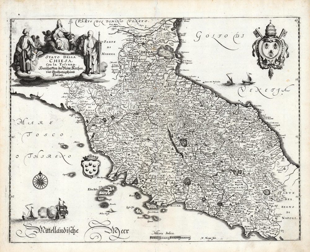
Stato Della Chiesa, Con la Toscana. Herschafften der Röm. Kirchen, und Großhertzogthumb Florentz.
1646 (undated) 10.75 x 14 in (27.305 x 35.56 cm) 1 : 1500000
1646 (undated) 10.75 x 14 in (27.305 x 35.56 cm) 1 : 1500000
Description
This is Matthias Merian's 1646 map of Tuscany and the Papal States, the territories in the Italian peninsula under the direct sovereign rule of the Pope. The region was bounded in the north by the Venetian Republic, and in the south by the Kingdom of Naples. The map presents the Stato Dell Chiesa during an extended period of increasing temporal power there: in the north, the Duchy of Ferrara is encompassed, as well as the Duchy of Urbino which had been re-absorbed in 1631.
A Closer Look
As is the case with many of Merian's maps, this work is a reduced copy of Willem Blaeu's similarly-titled 1634 map. Merian's reduction is nevertheless a skillful and attractive engraving, preserving the detail of the Dutch original. The cartouche is a beautifully executed copy of Blaeu's tableau of Saints Peter (bearing keys) and Michael (with a sword) flanking an allegorical representation of the Pope. Merian adds decorative elements not present in the source: two coats of arms. In the Gulf of Venice, Merian has added the coat of arms of Pope Urban VIII (the bees upon it were the symbol of his family, Barberini). In the Sea of Tuscany are displayed the Medici coat of arms: an interesting juxtaposition, as the Papal States and the Florentine Medicis had just been on opposing sides of the Wars of Castro. Merian emphasized that opposition in the German addition to the map's title, naming the domains ruled by the Roman Church and the Grand Duchy of Florence.Publication History and Census
This map was engraved by Matthäus Merian the Elder for inclusion in his 1646 Newe Archontologia cosmica. The atlas is well represented in institutional collections and the map appears on the market from time to time.CartographerS
Matthäus Merian (September 22, 1593 - June 19, 1650), sometimes referred to as 'the Elder' to distinguish from his son, was an important Swiss engraver and cartographer active in the early to mid 17th century. Merian was born in Basel and studied engraving in the centers of Zurich, Strasbourg, Nancy and Paris. In time Merian was drawn to the publishing mecca of Frankfurt, where he met Johann Theodor de Bry, son of the famed publisher Theodor de Bry (1528 - 1598) . Merian and De Bry produced a number of important joint works and, in 1617, Merian married De Bry's daughter Maria Magdalena. In 1623 De Bry died and Merian inherited the family firm. Merian continued to publish under the De Bry's name until 1626. Around this time, Merian became a citizen of Frankfurt as such could legally work as an independent publisher. The De Bry name is therefore dropped from all of Merian's subsequent work. Of this corpus, which is substantial, Merian is best known for his finely engraved and highly detailed town plans and city views. Merian is considered one of the grand masters of the city view and a pioneer of the axonometric projection. Merian died in 1650 following several years of illness. He was succeeded in the publishing business by his two sons, Matthäus (1621 - 1687) and Caspar (1627 - 1686), who published his great works, the Topographia and Theatrum Europeaum, under the designation Merian Erben (Merian Heirs). Merian's daughter, Anna Maria Sibylla Merian, became an important naturalist and illustrator. Today the German Travel Magazine Merian is named after the famous engraver. More by this mapmaker...
Willem Janszoon Blaeu (1571 - October 18, 1638), also known as Guillaume Blaeu and Guiljelmus Janssonius Caesius, was a Dutch cartographer, globemaker, and astronomer active in Amsterdam during the late 16th and early 17th centuries. Blaeu was born 'Willem Janszoon' in Alkmaar, North Holland to a prosperous herring packing and trading family of Dutch Reformist faith. As a young man, he was sent to Amsterdam to apprentice in the family business, but he found the herring trade dull and instead worked for his cousin 'Hooft' as a carpenter and clerk. In 1595, he traveled to the small Swedish island of Hven to study astronomy under the Danish Enlightenment polymath Tycho Brahe. For six months he studied astronomy, cartography, instrument making, globe making, and geodesy. He returned to Alkmaar in 1596 to marry and for the birth of his first son, Johannes (Joan) Blaeu (1596 – 1673). Shortly thereafter, in 1598 or 1599, he relocated his family to Amsterdam where he founded the a firm as globe and instrument makers. Many of his earliest imprints, from roughly form 1599 - 1633, bear the imprint 'Guiljelmus Janssonius Caesius' or simply 'G: Jansonius'. In 1613, Johannes Janssonius, also a mapmaker, married Elizabeth Hondius, the daughter of Willem's primary competitor Jodocus Hondius the Elder, and moved to the same neighborhood. This led to considerable confusion and may have spurred Willam Janszoon to adopt the 'Blaeu' patronym. All maps after 1633 bear the Guiljelmus Blaeu imprint. Around this time, he also began issuing separate issue nautical charts and wall maps – which as we see from Vermeer's paintings were popular with Dutch merchants as decorative items – and invented the Dutch Printing Press. As a non-Calvinist Blaeu was a persona non grata to the ruling elite and so he partnered with Hessel Gerritsz to develop his business. In 1619, Blaeu arranged for Gerritsz to be appointed official cartographer to the VOC, an extremely lucrative position that that, in the slightly more liberal environment of the 1630s, he managed to see passed to his eldest son, Johannes. In 1633, he was also appointed official cartographer of the Dutch Republic. Blaeu's most significant work is his 1635 publication of the Theatrum orbis terrarum, sive, Atlas Novus, one of the greatest atlases of all time. He died three years later, in 1638, passing the Blaeu firm on to his two sons, Cornelius (1616 - 1648) and Johannes Blaeu (September 23, 1596 - December 21, 1673). Under his sons, the firm continued to prosper until the 1672 Great Fire of Amsterdam destroyed their offices and most of their printing plates. Willem's most enduring legacy was most likely the VOC contract, which ultimately passed to Johannes' son, Johannes II, who held the position until 1617. As a hobbyist astronomer, Blaeu discovered the star now known as P. Cygni. Learn More...
Source
Merian, M., Newe Archontologia cosmica, (Frankfurt am Main) 1646.
Condition
Very good. Few marginal spots; scuffing at centerfold with virtually no loss, else excellent.
References
OCLC 164592542.