1733 / 1781 D'Anville Map of the Rio De La Plata Watershed
Paraguay-anville-1733$500.00

Title
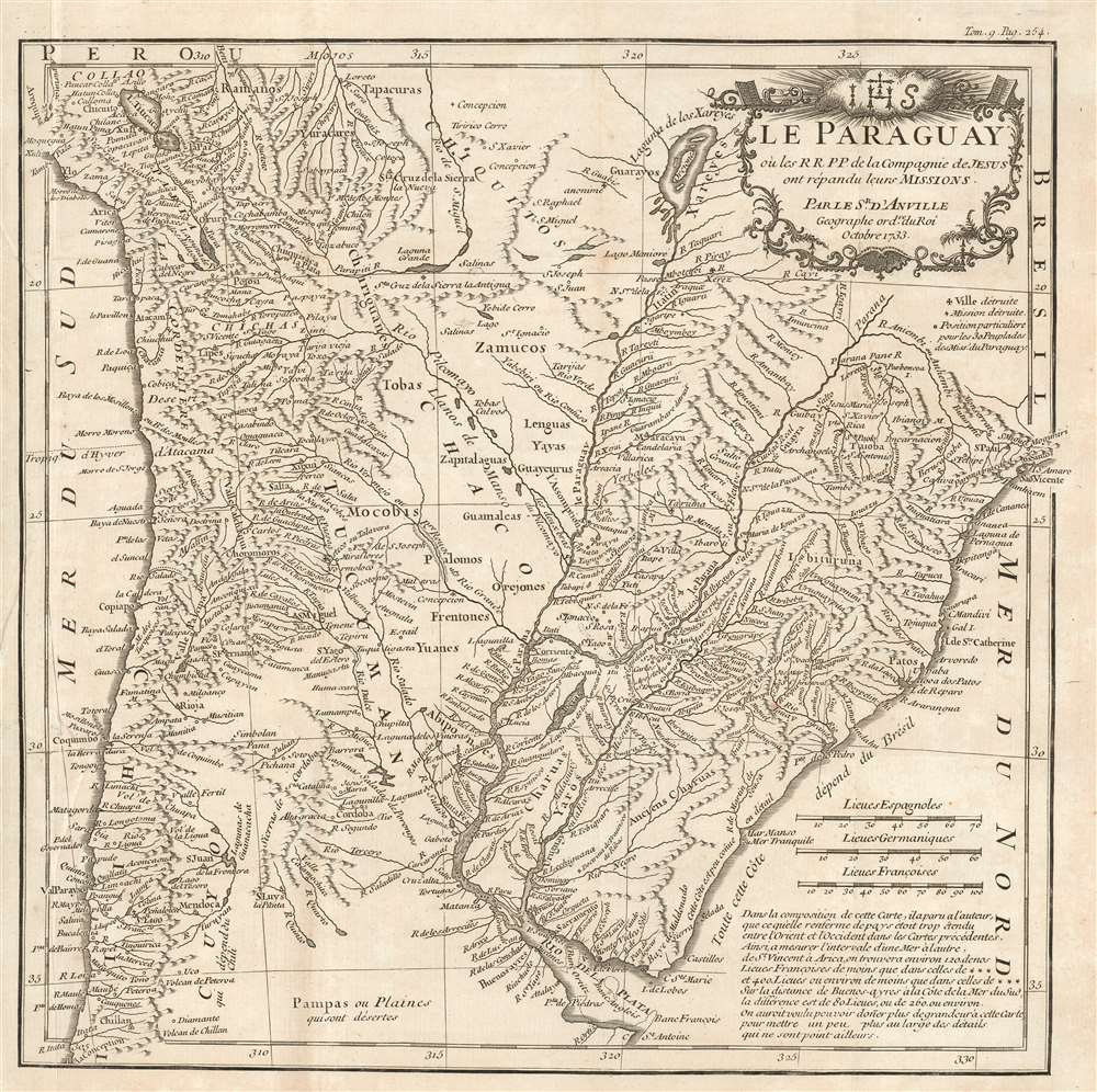
Le Paraguay, où les R.R.P.P. de la Compagnie de Jesus ont répandu leurs missions.
1733 (dated) 12 x 11.75 in (30.48 x 29.845 cm) 1 : 8000000
1733 (dated) 12 x 11.75 in (30.48 x 29.845 cm) 1 : 8000000
Description
This is J. B. B. d'Anville's attractive, detailed map of Paraguay, Uruguay, part of Chile, and northern Argentina based on the reports of Jesuit missionaries, and intended for inclusion in a collection of those reports. It updates D'Avila's 1726 map of the Jesuit Provinces, covering the area now comprising parts of Chile, Paraguay, Bolivia, Peru, Brazil, Uruguay, and Argentina. The rivers of the region are shown in detail and mountains are indicated pictorially. Towns and villages are marked. A key indicates the presence of destroyed missions and villages, and the locations of tribes contacted by the Jesuits. The map's elegant cartouche is surmounted by the Jesuit arms. It should be noted that in the period between the execution of the map in 1733 and the printing of this 1781 edition, the Jesuits had been expelled from South America: from Portuguese territories in 1759 and the Spanish territories in 1767.
Laguna de Xareyes
The mythical Laguna de Xareyes is illustrated here as the northern source of the Paraguay River. The Xareyes, a corruption of 'Xaraies' meaning 'Masters of the River', were an indigenous people occupying what are today parts of Brazil's Matte Grosso and the Pantanal. When Spanish and Portuguese explorers first navigated up the Paraguay River, as always in search of El Dorado, they encountered the vast Pantanal flood plain at the height of its annual inundation. Understandably misinterpreting the flood plain as a gigantic inland sea, they named it after the local inhabitants, the Xaraies. The Laguna de los Xarayes almost immediately began to appear on early maps of the region and, at the same time, to take on a legendary quality. Later missionaries and chroniclers, particularly Díaz de Guzman, imagined an island in this lake and curiously identified it as 'Island of Paradise,'...an island [of the Paraguay River] more than ten leagues [56 km] long, two or three [11-16 km] wide. A very mild land rich in a thousand types of wild fruit, among them grapes, pears and olives: the Indians created plantations throughout, and throughout the year sow and reap with no difference in winter or summer, ... the Indians of that island are of good will and are friends to the Spaniards; Orejón they call them, and they have their ears pierced with wheels of wood ... which occupy the entire hole. They live in round houses, not as a village, but each apart though keep up with each other in much peace and friendship. They called of old this island Land of Paradise for its abundance and wonderful qualities.
Publication History and Census
This map was engraved for Du Halde's 1734 Lettres édifiantes et curieuses, écrites des missions étrangeres, par quelques missionnaires de la Compagnie de Jesus. This identical map, with the pagination altered, was included in the 1781 Lettres édifiantes et curieuses écrites des missions étrangères published by Merigot in 1781. The book is well represented in institutional collection, and the separate map (in both editions) appears in 16 entries in OCLC.Cartographer
Jean Baptiste Bourguignon d'Anville (1697 - 1782) was perhaps the most important and prolific cartographer of the 18th century. D'Anville's passion for cartography manifested during his school years when he amused himself by composing maps for Latin texts. There is a preserved manuscript dating to 1712, Graecia Vetus, which may be his earliest surviving map - he was only 15 when he drew it. He would retain an interest in the cartography of antiquity throughout his long career and published numerous atlases to focusing on the ancient world. At twenty-two D'Anville, sponsored by the Duke of Orleans, was appointed Geographer to the King of France. As both a cartographer and a geographer, he instituted a reform in the general practice of cartography. Unlike most period cartographers, D'Anville did not rely exclusively on earlier maps to inform his work, rather he based his maps on intense study and research. His maps were thus the most accurate and comprehensive of his period - truly the first modern maps. Thomas Basset and Philip Porter write: "It was because of D'Anville's resolve to depict only those features which could be proven to be true that his maps are often said to represent a scientific reformation in cartography." (The Journal of African History, Vol. 32, No. 3 (1991), pp. 367-413). In 1754, when D'Anville turned 57 and had reached the height of his career, he was elected to the Academie des Inscriptions. Later, at 76, following the death of Philippe Buache, D'Anville was appointed to both of the coveted positions Buache held: Premier Geographe du Roi, and Adjoint-Geographer of the Academie des Sciences. During his long career D'Anville published some 211 maps as well as 78 treatises on geography. D'Anville's vast reference library, consisting of over 9000 volumes, was acquired by the French government in 1779 and became the basis of the Depot Geographique - though D'Anville retained physical possession his death in 1782. Remarkably almost all of D'Anville's maps were produced by his own hand. His published maps, most of which were engraved by Guillaume de la Haye, are known to be near exact reproductions of D'Anville' manuscripts. The borders as well as the decorative cartouche work present on many of his maps were produced by his brother Hubert-Francois Bourguignon Gravelot. The work of D'Anville thus marked a transitional point in the history of cartography and opened the way to the maps of English cartographers Cary, Thomson and Pinkerton in the early 19th century. More by this mapmaker...
Source
Du Halde, J.-B. Lettres édifiantes et curieuses écrites des missions étrangères, (Paris: Merigot) 1781.
Condition
Very good. Two mended tears at insertion point, one just touching border, with no loss. Removed from book, book present in excellent condition.
References
OCLC 276567728.