1756 Bellin Map of southern South America (Paraguay, Argentina, Chile, Brazil)
Paraguay-bellin-1756$150.00

Title
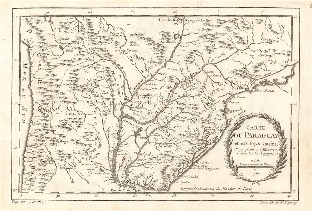
Carte du Paraguay et des pays voisins.
1756 (dated) 8 x 12 in (20.32 x 30.48 cm) 1 : 12170400
1756 (dated) 8 x 12 in (20.32 x 30.48 cm) 1 : 12170400
Description
This is a 1756 Jacques-Nicolas Bellin map of southern South America. The map depicts the region from the Pacific Ocean to the Atlantic Ocean and Rio de Janeiro and from La Paz and the mythical Laguna de Xarayes to the Rio de la Plata and Buenos Aires. Highly detailed, numerous colonial cities, towns, and villages are identified, including Asuncion (Assomption), Buenos Aires, Rio de Janeiro, La Paz, and Montevideo. The Paraguay, Parana, and Uruguay Rivers are all illustrated in detail, with myriad tributaries branching off from each one.
The Laguna de Xarayes
The mythical Laguna de Xarayes, or as it is labeled here Lac des Xareyes, is illustrated here as the northern terminus, or source, of the Paraguay River. The Xarayes, a corruption of 'Xaraies' meaning 'Masters of the River', were an indigenous people occupying what are today parts of Brazil's Matte Grosso and the Pantanal. When Spanish and Portuguese explorers first navigated up the Paraguay River, as always in search of El Dorado, they encountered the vast Pantanal flood plain at the height of its annual inundation. Understandably misinterpreting the flood plain as a gigantic inland sea, they named it after the local inhabitants, the Xaraies. The Laguna de los Xarayes almost immediately began to appear on early maps of the region and, at the same time, to take on a legendary quality. Later missionaries and chroniclers, particularly Díaz de Guzman, imagined an island in this lake and curiously identified it as an 'Island of Paradise,'...an island [of the Paraguay River] more than ten leagues [56 km] long, two or three [11-16 km] wide. A very mild land rich in a thousand types of wild fruit, among them grapes, pears and olives: the Indians created plantations throughout, and throughout the year sow and reap with no difference in winter or summer, ... the Indians of that island are of good will and are friends to the Spaniards; Orejón they call them, and they have their ears pierced with wheels of wood ... which occupy the entire hole. They live in round houses, not as a village, but each apart though keep up with each other in much peace and friendship. They called of old this island Land of Paradise for its abundance and wonderful qualities.
Publication History
This map was created by Jacques-Nicolas Bellin for publication in Abbé Prévost's Histoire Générale des Voyages in 1756.Cartographer
Jacques-Nicolas Bellin (1703 - March 21, 1772) was one of the most important cartographers of the 18th century. With a career spanning some 50 years, Bellin is best understood as geographe de cabinet and transitional mapmaker spanning the gap between 18th and early-19th century cartographic styles. His long career as Hydrographer and Ingénieur Hydrographe at the French Dépôt des cartes et plans de la Marine resulted in hundreds of high quality nautical charts of practically everywhere in the world. A true child of the Enlightenment Era, Bellin's work focuses on function and accuracy tending in the process to be less decorative than the earlier 17th and 18th century cartographic work. Unlike many of his contemporaries, Bellin was always careful to cite his references and his scholarly corpus consists of over 1400 articles on geography prepared for Diderot's Encyclopedie. Bellin, despite his extraordinary success, may not have enjoyed his work, which is described as "long, unpleasant, and hard." In addition to numerous maps and charts published during his lifetime, many of Bellin's maps were updated (or not) and published posthumously. He was succeeded as Ingénieur Hydrographe by his student, also a prolific and influential cartographer, Rigobert Bonne. More by this mapmaker...
Condition
Very good. Even overall toning. Light wear along original fold lines. Blank on verso.
References
OCLC 876672902.