1984 Wall Map of the Republic of Paraguay
Paraguay-geograficomilitar-1984$2,000.00

Title
Paraguay. Dirección del Servicio Geográfico Militar.
1984 (dated) 49.5 x 41.75 in (125.73 x 106.045 cm) 1 : 1000000
1984 (dated) 49.5 x 41.75 in (125.73 x 106.045 cm) 1 : 1000000
Description
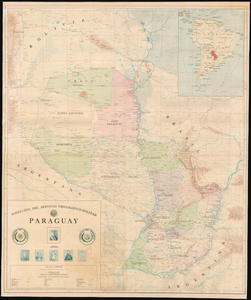
This large, scarce, detailed map is an official map of the Republic of Paraguay, published by that country's Dirección del Servicio Geográfico Militar. The map was printed in 1984, in the last years of the dictatorial regime - known as El Stronato, or el Stronismo - of President General don Alfredo Stroessner. A military, corporate work, there are no specific cartographers named. It is imposing, color-printed to four sheets, and joined as a wall map.
A Closer Look
The map details the whole of the Republic of Paraguay; an inset map shows the location of the country landlocked in the middle of South America. Details include railroads, power lines, and roads (paved and unpaved.) Cities, towns, and forts are indicated with symbols to distinguish their specific type. Symbols are used to differentiate between bodies of water and rivers that are permanent, and those which are intermittent (especially important for the arid, western Chaco.) In the east along the upper Parana River is the Itaipu Dam, and the neighboring Puerto Presidente Stroessner. The western region - Chaco, Nueva Asunción and Alto Paraguay - are predominantly empty with a scattering of forts. The towns, mountains, and forts of these provinces mainly take their names from Paraguayan military officers who had fought in the Chaco War (1932 - 1935) with Bolivia, whose outcome resulted in control over this area definitively passing to Paraguay.President General don Alfredo Stroessner
A career soldier and adroit upper-ranks politician, Stroessner, with the support of the army and the dominant, conservative Colorado Part, took power in a 1954 coup. He held Paraguay in a dictatorial regime until 1989, suspending civil liberties and enacting constitutional changes in 1967 and 1977 to permit himself to be re-elected indefinitely. His regime, being anti-communist, was aided and abetted by the United States until the Carter administration. This situation remained in place until, six months after the 1988 election, he was overthrown in a February 1989 coup d'état led by a close confidant with the support of the army (whose leaders feared that the presidency would otherwise pass to one of Stroessner's sons.) He was exiled to Brazil, where he spent the rest of his life. The cartouche is decorated with the portraits of a select number of Paraguayan leaders: the then-current president, General don Alfredo Stroessner (1912 - 2006); Gaspar de Francia (1766-1840), Paraguay's first dictator; President Carlos Lopez (1792-1862), known as 'El Supremo;' his son, the disastrous Francisco Solano Lopez (1826 -1870); General Bernardino Caballero (1839-1912), of Stroessner's Colorado Party; and José Félix Estigarribia (1888 - 1940), Stroessner's former commander and erstwhile president whose dissolution of the legislature and suspension of the constitution laid the foundations for Stroessner's own regime.Publication History and Census
This map was printed in its fourth edition in 1984; a third edition was printed that same year. We have not identified a first edition, although a 1982 second edition appears in OCLC. We see fifteen examples of this fourth edition in institutional collections; we have not seen any on the market.Condition
Fair. Top and bottom margins extended, with reinstated loss to borders. Various mended tears; laid down on linen and fully stabilized.
References
OCLC 13189375.