This item has been sold, but you can get on the Waitlist to be notified if another example becomes available, or purchase a digital scan.
1862 Guittet View and Map of Paris, France and Vicinity
Paris-guittet-1862$325.00

Title
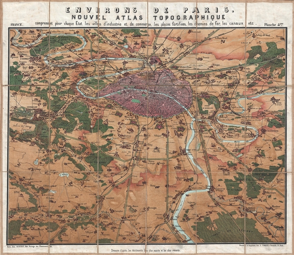
Environs de Paris. Nouvel Atlas Topographique comprenant pour chaque Etat les villes d'industrie et de commerce, les places fortifiées, les chemins de fer, les canaux etc.
1862 (undated) 22 x 25 in (55.88 x 63.5 cm)
1862 (undated) 22 x 25 in (55.88 x 63.5 cm)
Description
Stunning 1862 chromolithograph view and map of Paris, France, and vicinity by Guittet. Centered on the Paris and the Seine River, this map covers from Triel to Varinnes and from Sevran to St. Remi. This curious production combines aspects of both a map and a view. Paris, in pink, seems almost three dimensional, with its towers, monuments, and other important buildings drawn in profile. The Theirs Wall and the the ring forts are clearly visible. To the west a passage through forests leads to Versailles. Other tree lined roads lead to Orleans, Fontainebleau, Bale, and elsewhere. In most towns, individual buildings are rendered and some important buildings are recognizable.
This map was issued as part of a four map atlas, the Nouvel Atlas Topographique issued by A. Compan in 1862.
This map was issued as part of a four map atlas, the Nouvel Atlas Topographique issued by A. Compan in 1862.
Condition
Very good. Dissected and mounted on linen in 18 panel. Original linen in good condition.
References
Vallee, Leon, Catalogue des plans de Paris et des cartes de l'ile de France, 1462 (C 18850-181). OCLC 494652823, 494999094 (Atlas).