This item has been sold, but you can get on the Waitlist to be notified if another example becomes available, or purchase a digital scan.
1833 Eustache Hérisson Map of Paris, France
Paris-herisson-1833$425.00

Title
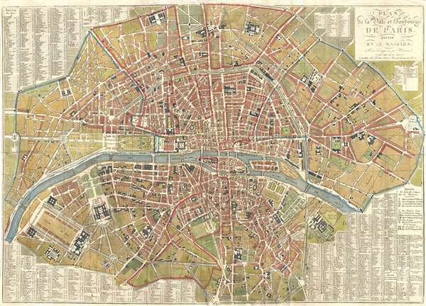
Plan de la Ville et Faubourgs de Paris, Divise en 12 Mairies.
1833 (dated) 22.5 x 31.5 in (57.15 x 80.01 cm) 1 : 10500
1833 (dated) 22.5 x 31.5 in (57.15 x 80.01 cm) 1 : 10500
Description
A stunning large 1833 map of Paris, France, by Eustache Hérisson. Centered on the Ile de la Cité, this map covers central Paris from the Champ de Mars and the Arc de Triomphe to the Place du Trone (Place de la Nation), and from the Abattoir to the Observatoire de Paris. The map shows gardens, important buildings, cemeteries, Parks, Streets, public places, Bridges, and 12 districts, or Maries. Surrounding the map is a comprehensive street index. This is the Paris of Louis-Philippe, Victor Hugo, Théodore Rousseu, Jean-Pierre Dantan, and the June Rebellion. That year, sadly, there was also a terrible cholera outbreak threat forced the cancellation of the 1833 Salon de Paris.
This map was published by the Chez Jean firm. Although many similar maps were published, revised, and republished by various firms from about 1780, the present example is rare with only 2 examples appearing in the OCLC.
This map was published by the Chez Jean firm. Although many similar maps were published, revised, and republished by various firms from about 1780, the present example is rare with only 2 examples appearing in the OCLC.
CartographerS
Eustache Hérisson (1759 – 1818) was a French cartographer and geographical engineer active in Paris during the early years of the 19th century. Hérisson was a student of the 18th century hydrography Rigobert Bonne. He was a member of the Société Royale. Much of his work was republished posthumously by Bassett, Brue, and others. More by this mapmaker...
Pierre Jean (1754 - 1829) was a French engraver, publisher, print seller, and map maker active in Paris in the late 18th and early 19th centuries. Jean entered the engraving and printing business on June 7 of 1784 when he married the daughter of Louis-Joseph Mondhare, a prominent French engraver, print seller and map publisher. Mondhare changed the name of his firm to Mondhare & Jean. Under Mondhare, for about 12 years, Jean mastered the in-and-outs of the engraving and map publishing business. Mondhare retired in 1796, leaving Jean his business and printing plates. Jean subsequently continued to publish on his own account, as Chez Jean, from the old Mondhare & Jean offices at 32 Rue Saint-Jean de Beauvais. Learn More...
Condition
Very good. Minor verso reinforcements on original fold lines.
References
OCLC 892737530.