This item has been sold, but you can get on the Waitlist to be notified if another example becomes available, or purchase a digital scan.
1638 Merian View of Paris, France
Paris-merian-1638-2$1,250.00

Title
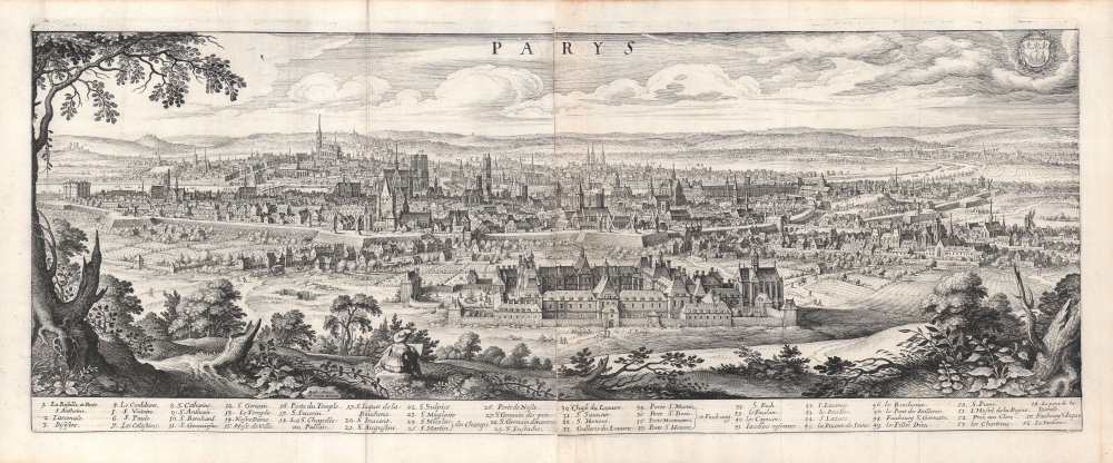
Parys.
1638 (undated) 10.5 x 27.5 in (26.67 x 69.85 cm)
1638 (undated) 10.5 x 27.5 in (26.67 x 69.85 cm)
Description
This is a 1638 Matthaus Merian view of Paris, France - arguably the most desirable of Merian's panoramas in that it is also a self-portrait.
Fifty-six sites are listed in the numerical index below the view. Notre Dame can be recognized, as can the Bastille, and other structures both in and outside the city walls. The Seine winds through the city and off into the distance. Diminutive figures move along the roads and on the grounds of the Hôpital Saint-Louis.
A Closer Look
The view is oriented to the southwest, showcasing the Hôpital Saint-Louis with the city beyond it. The view was probably drawn from atop the Chauve-mont, now the site of Paris' Parc des Buttes Chaumont. It was almost certainly drawn by Merian himself: the view bears the Latin inscription Math. Merian as vivum delineav. To underscore this, Merian includes himself in the picture, seated upon a rock sketching. Merian frames the panorama with the trees and bracken of the hillside from which he drew the view, emphasizing that it was drawn from life.Fifty-six sites are listed in the numerical index below the view. Notre Dame can be recognized, as can the Bastille, and other structures both in and outside the city walls. The Seine winds through the city and off into the distance. Diminutive figures move along the roads and on the grounds of the Hôpital Saint-Louis.
Publication History and Census
This view was created by Matthaus Merian for inclusion in his Archontologia Cosmica, published in Frankfurt am Main in 1638 with further editions in 1646 and 1649. After his death, his son Caspar re-engraved this view on a new plate. This latter view includes a note dating it to 1620; although it removes the 'ad vivum' note of the original, it does retain the self-portrait of the elder Merian. Caspar produced a further view in 1654 from a different perspective. This first plate is cataloged in eight institutional collections in OCLC.Cartographer
Matthäus Merian (September 22, 1593 - June 19, 1650), sometimes referred to as 'the Elder' to distinguish from his son, was an important Swiss engraver and cartographer active in the early to mid 17th century. Merian was born in Basel and studied engraving in the centers of Zurich, Strasbourg, Nancy and Paris. In time Merian was drawn to the publishing mecca of Frankfurt, where he met Johann Theodor de Bry, son of the famed publisher Theodor de Bry (1528 - 1598) . Merian and De Bry produced a number of important joint works and, in 1617, Merian married De Bry's daughter Maria Magdalena. In 1623 De Bry died and Merian inherited the family firm. Merian continued to publish under the De Bry's name until 1626. Around this time, Merian became a citizen of Frankfurt as such could legally work as an independent publisher. The De Bry name is therefore dropped from all of Merian's subsequent work. Of this corpus, which is substantial, Merian is best known for his finely engraved and highly detailed town plans and city views. Merian is considered one of the grand masters of the city view and a pioneer of the axonometric projection. Merian died in 1650 following several years of illness. He was succeeded in the publishing business by his two sons, Matthäus (1621 - 1687) and Caspar (1627 - 1686), who published his great works, the Topographia and Theatrum Europeaum, under the designation Merian Erben (Merian Heirs). Merian's daughter, Anna Maria Sibylla Merian, became an important naturalist and illustrator. Today the German Travel Magazine Merian is named after the famous engraver. More by this mapmaker...
Source
Merian, M., Archontologia cosmica sive imperiorum, (Frankfurt am Main) 1638.
Condition
Very good. Printed to two separate plates, joined at publication. Marginal mend to fold away from printed image. Else excellent.
References
OCLC 500600151. c.f. Rumsey 13088.076 (Plate 2, c. 1660).