This item has been sold, but you can get on the Waitlist to be notified if another example becomes available, or purchase a digital scan.
1862 Vuillemin Wall Map of Paris
Paris-Vuillemin-1862$425.00

Title
Nouveau plan illustré de la ville de Paris avec le système complet de ses fortifications et forts détachés et les nouvelles divisions en 20 arrondissements.
1862 (dated) 33.5 x 43 in (85.09 x 109.22 cm) 1 : 11000
1862 (dated) 33.5 x 43 in (85.09 x 109.22 cm) 1 : 11000
Description
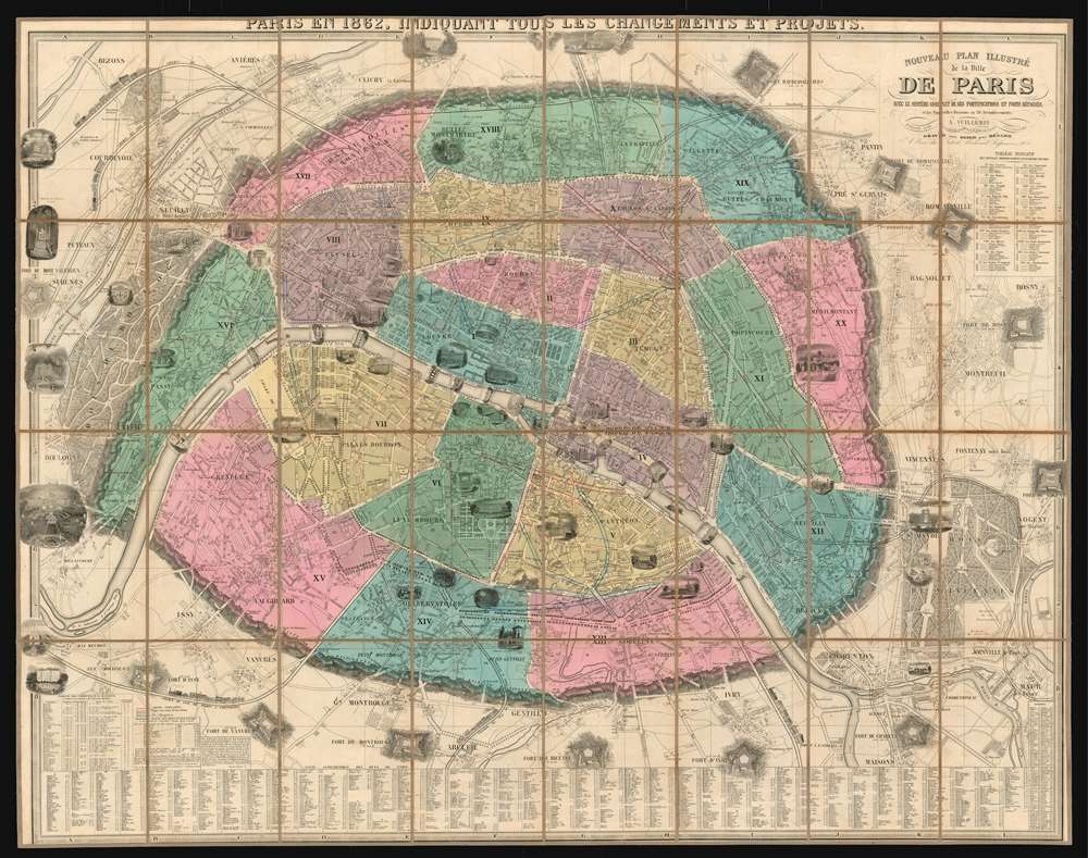
This is a spectacular 1862 folding wall map of Paris, France by the French cartographer Alexandre Vuillemin. This richly-detailed plan shows a city rapidly leaving its medieval past behind. It embraces Paris' 20 arrondisments, along with twelve surrounding forts and strongpoints. Dozens of architectural views depict important and historic buildings and parks. This frequently-updated plan highlights the current changes to Paris' plan under Haussmann: Superimposed over the original layout are the Rue de Turbigo, the Boulevard St. Germain, the Avenue de l'Opera, and many others. Five railroads, with trains charmingly illustrated, are shown leading in and out of the city.
Haussmannization or the 'Grands Travaux'
This map was published at the height of the 'Grand Traveaux', the transformation of Paris by Emperor Napoléon III and Baron Georges-Eugène Haussmann. Completed between 1853 and 1870, the renovation of Paris consisted of the demolition of medieval neighborhoods that were deemed overcrowded and unhealthy; the building of wide avenues; new parks and squares; the annexation of the suburbs surrounding Paris; and the construction of new sewers, fountains and aqueducts. The work, however, continued until 1927. Known in French as the 'Grands Travaux,' Haussmann's redesign of Paris defined it as a modern city, with narrow alleyways and confusing streets replaced by a broad network of grand boulevards, imposing facades, parks, and monuments. Some of the more famous parts of Paris today, including the famous design of Étoile, where the Arc de Triomphe is located, were constructed during Haussmann's tenure as Prefect.The Fortification of Paris
This map exhibits the Theirs Wall in all of its glory. Shocked seizure of Paris by foreign enemies during the 1814 Battle of Paris, the French King at the time, Louis-Philippe (1830 - 1848), conceived of a board network of walls and forts he believed would make Paris impregnable. The project was met with immediate opposition, some of which claimed that the walls were not defensive, but rather intended to control Parisians in the event of an anti-monarchal rebellion. Nonetheless, under a plan prepared by Marshal General Jean-de-Dieu Soult (1759 - 1861), construction began in 1841. The completed fortifications, named the Thiers Wall after the French Prime Minister at the time, Adolphe Theirs (1797 - 1877), were, at enormous expense, completed in 1844. The walls were 33 kilometers long and consisted of 94 bastions, 17 gates, 23 minor road crossings, and eight railroad gates. By 1919, advancements in military technology made the walls obsolete, leading them to be fully deconstructed by 1929 and replaced with the Boulevard Périphérique.Publication History and Census
This map was first executed in 1844, with updated editions produced virtually every year until about 1865. Many editions appear catalogued in OCLC; this 1862 edition is however not among them, and it appears to be scarce on the market.Cartographer
Alexandre Aimé Vuillemin (1812 - 1880) was an engraver, publisher, and editor based in Paris, France in the middle of the 19th century. Despite a prolific publishing career, much of Vuillemin's life is shrouded in mystery. In 1852, he married Josephine Caroline Goret and they had at least one child, Ernestine Adèle Vuillemin, later in the same year. What is known is that his studied under the prominent French Auguste Henri Dufour (1798 - 1865). Vuillemin's most important work his detailed, highly decorative large format Atlas Illustre de Geographie Commerciale et Industrielle. More by this mapmaker...
Condition
Very good condition. Dissected and mounted on linen for folding as issued. Original boards separate but present.
References
Compare with 1860, OCLC: 617729017