This item has been sold, but you can get on the Waitlist to be notified if another example becomes available, or purchase a digital scan.
1877 Vuillemin Folding Pocket Map of Paris, France
Paris-vuillemin-1877$212.50

Title
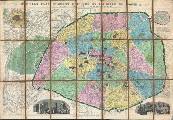
Nouveau Plan Complet Illustre dela Ville de Paris en 1877 Divise en 20 Arrondissements.
1877 (dated) 25 x 36 in (63.5 x 91.44 cm)
1877 (dated) 25 x 36 in (63.5 x 91.44 cm)
Description
A spectacular 1877 folding pocket map of Paris, France by the French cartographer A. Vuillemin. Covers the entire city and environs in spectacular detail at the level of individual streets, bridges and buildings. Divided according to 20 Arrondisments. Important and historic buildings are shown as views. These include the Arc de Triomphe, the Palace Royal, Notre Dame, the Hotel des Invalides, the Pantheon, the Tour St. Jacques, and the Hotel de Ville, among others. An inset map in the upper left quadrant shows the greater Paris vicinity as far as Versailles. Another inset map, in the upper right quadrant, details the Arrondisment system. In the lower left and lower right quadrants there are beautiful engraved views depicting the monuments of Paris in composite. All text is in French. Engraved by Charles Dyonnet for A. Vuillemin in 1877.
CartographerS
Alexandre Aimé Vuillemin (1812 - 1880) was an engraver, publisher, and editor based in Paris, France in the middle of the 19th century. Despite a prolific publishing career, much of Vuillemin's life is shrouded in mystery. In 1852, he married Josephine Caroline Goret and they had at least one child, Ernestine Adèle Vuillemin, later in the same year. What is known is that his studied under the prominent French Auguste Henri Dufour (1798 - 1865). Vuillemin's most important work his detailed, highly decorative large format Atlas Illustre de Geographie Commerciale et Industrielle. More by this mapmaker...
Charles Dyonnet (fl. c. 1822 - c. 1880) was an extremely active Paris based engraver working in the mid to late 19th century. From his offices at 220 Rue St. Jacques, Paris, Dyonnet engraved numerous maps for many of the most prominent 19th French cartographic publishers including Vuillemin, Dufour, Fremin and Duvotenay. From 1850-1861, he held the coveted position of "Graveur du Dépot de la Marine," and in this position engraved numerous French naval and military maps. Dyonnet had a detail oriented and aesthetically minded hand and is responsible from some of the most beautiful French maps to emerge during the 19th century. Learn More...
Condition
Very good condition. Original sail cloth or linen backing in good condition. Minor soiling to edges.