1841 Langlois Map of Paris, Focusing on Walls and Fortifications
ParisEnvirons-langloishyacinthe-1841$1,800.00

Title
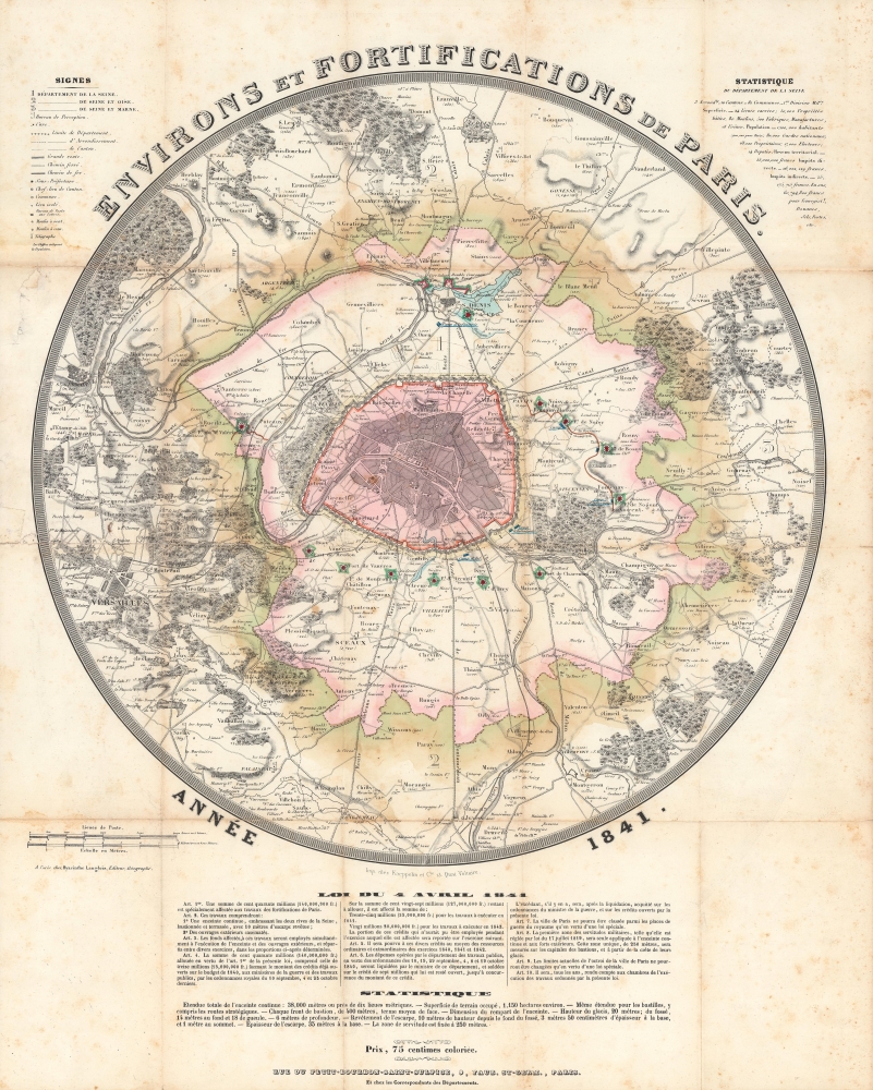
Environs et fortifications de Paris, année 1841.
1841 (undated) 22.5 x 18 in (57.15 x 45.72 cm) 1 : 100000
1841 (undated) 22.5 x 18 in (57.15 x 45.72 cm) 1 : 100000
Description
An impressive, hand-colored c. 1841 representation of Paris and environs by Hyacinthe Langlois. The map highlights the city's defenses, in particular the 'Thiers Wall' constructed between 1841 and 1846.
The text of the Law of April 4, 1841, which allocated funds for the fortifications, is included below the map, as are statistics that discuss features of the walls in greater detail. A legend at top left explains abbreviations and symbols while a list at top-right provides statistics about the département de la Seine.
Nonetheless, under a plan prepared by Marshal General Jean-de-Dieu Soult (1759 - 1861), construction began in 1841. The fortifications, named the Thiers Wall after the French Prime Minister at the time, Adolphe Theirs (1797 - 1877), were completed at enormous expense in 1844, with some additions made through 1846. The walls were 33 kilometers long and consisted of 94 bastions, 17 gates, 23 minor road crossings, and eight railroad gates.
Unfortunately for Parisians, the walls were not able to fend off an invading force during the Franco-Prussian War (1870 - 1871), as the Prussians had state-of-the-art artillery that could fire from well beyond the range of French defensive guns. Although the walls held, the Prussians were able to besiege the city and hammer it continually with artillery. Losses on the battlefield elsewhere removed all hope of a relief force breaking the siege and Paris surrendered in late January 1871.
Afterwards, a conservative and monarchist government was elected, headed by none other than Adolphe Thiers. Leftists in Paris were irate at this turn of events and rose up in March 1871 to oust the national government. Thus, Paris was once again besieged, this time by the French national government, with Prussian support, against the communards of the Paris Commune. Lacking much in the way of heavy weapons, the communards were unable to prevent the breach of the city walls by government forces, which came on May 21 and was followed by the notorious 'semaine sanglante.' By 1919, advancements in military technology made clear that the walls were obsolete, leading to their complete deconstruction by 1929 and replacement with the Boulevard Périphérique.
A Closer Look
Coverage includes the entirety of Paris within the proposed walls and the surrounding Département de la Seine, which is shaded in pink. The wider area, beginning from the green shaded lines, was part of the Département de Seine-et-Oise, which completely surrounded the Département de la Seine, and the nearby Département de Seine et Marne. Surrounding the city walls are a string of forts. Familiar sites in the environs of Paris are clearly visible, such as the Bois de Boulogne and Versailles.The text of the Law of April 4, 1841, which allocated funds for the fortifications, is included below the map, as are statistics that discuss features of the walls in greater detail. A legend at top left explains abbreviations and symbols while a list at top-right provides statistics about the département de la Seine.
The Fortification of Paris
Prior to the Napoleonic Wars, Paris was considered safe from invasion due to border defenses and was thought too large to fortify in any case. But the easy seizure of the capital by foreign enemies during the 1814 Battle of Paris caused French military thinkers to reconsider these assumptions. Under the July Monarchy (1830 - 1848), a broad network of walls and forts was conceived that were intended to make Paris impregnable. The project was met with immediate opposition, some of which claimed that the walls were not defensive, but rather intended to control Parisians in the event of an anti-monarchal rebellion (an assumption that proved prescient).Nonetheless, under a plan prepared by Marshal General Jean-de-Dieu Soult (1759 - 1861), construction began in 1841. The fortifications, named the Thiers Wall after the French Prime Minister at the time, Adolphe Theirs (1797 - 1877), were completed at enormous expense in 1844, with some additions made through 1846. The walls were 33 kilometers long and consisted of 94 bastions, 17 gates, 23 minor road crossings, and eight railroad gates.
Unfortunately for Parisians, the walls were not able to fend off an invading force during the Franco-Prussian War (1870 - 1871), as the Prussians had state-of-the-art artillery that could fire from well beyond the range of French defensive guns. Although the walls held, the Prussians were able to besiege the city and hammer it continually with artillery. Losses on the battlefield elsewhere removed all hope of a relief force breaking the siege and Paris surrendered in late January 1871.
Afterwards, a conservative and monarchist government was elected, headed by none other than Adolphe Thiers. Leftists in Paris were irate at this turn of events and rose up in March 1871 to oust the national government. Thus, Paris was once again besieged, this time by the French national government, with Prussian support, against the communards of the Paris Commune. Lacking much in the way of heavy weapons, the communards were unable to prevent the breach of the city walls by government forces, which came on May 21 and was followed by the notorious 'semaine sanglante.' By 1919, advancements in military technology made clear that the walls were obsolete, leading to their complete deconstruction by 1929 and replacement with the Boulevard Périphérique.
Publication History and Census
This map was prepared by Hyacinthe Langlois and printed by Kaeppelin et Cie in Paris. The author does not appear to refer to Eustache-Hyacinthe Langlois, a celebrated painter and engraver who had died four years before this map's publication and who was based in Rouen. The map is quite rare; its only listing in the OCLC is with the Getty Research Institute in Los Angeles, though that example lists a different printer (Imprimerie Simon).CartographerS
Hyacinthe Langlois (fl. c. 1800 - 1852) was a Parisian publishing house specializing in maps, atlases, and travel literature. They do not appear to have any relation with Eustache-Hyacinthe Langlois, a contemporary artist and engraver, who spent most of his adult life in Rouen. More by this mapmaker...
Kaeppelin et Cie (fl. c. 1839 - 1860) was a Parisian publisher of prints and maps based at 15 Quai Voltaire. It appears to have developed an expertise in works dealing with the Anglophone world, including North America and Australia. Learn More...
Condition
Average. Toning along fold lines. Foxing throughout. Repaired tears at left margin.
References
OCLC 913272340.