1666 Pieter Goos Chart of Patagonia and Tierra del Fuego (Argentina, Chile, Uruguay)
Patagonia-goos-1666$2,500.00

Title
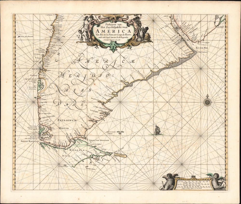
Paskaarte van Het Zuydelijckste van America Van Rio de la Plata, tot Caap de Hoorn, ende inde Zuyd Zee tot B. de Koquimbo. Nieuwlijcks Vijtgegeven Anno 1666.
1666 (dated) 17.75 x 21.5 in (45.085 x 54.61 cm) 1 : 8000000
1666 (dated) 17.75 x 21.5 in (45.085 x 54.61 cm) 1 : 8000000
Description
This is Pieter Goos' 1666 nautical map of the southernmost parts of South America, from the region around the Rio de la Plata to Tierra del Fuego. As with Goos' other output, this is among the most beautifully engraved regional nautical charts. This is the second-earliest specific chart of the region, predating only the work of Johannes van Loon.
Nevertheless, the chart reveals the efforts of Dutch mariners to span the globe, both via the Strait of Magellan and the Strait of Le Maire. For example, the islands dotting the southern extreme of the map were surveyed during the fateful 1624 voyage of Jacques l'Hermite (1582 - 1624). Also spotted by Dutch explorers, the Seybald Islands appear, representing an early glimpse of the Falkland Islands Archipelago.
A Closer Look
Goos' chart extends from about 30°S to about 62°S, thus presenting an area just north of the Rio de la Plata (on the east coast) and the Chilean bays of La Serena and Coquimbo on the west coast. The chart reaches several degrees beyond the Strait of Magellan and Tierra del Fuego. The latter is unambiguously an island, although Goos has marked its southwest coast with a dotted line to emphasize uncertainty. Gerritsz's subsequent 1630 chart and van Loon's 1666 chart present this coast, definitively and incorrectly, with a solid line. The actual, fjord-ridden coastline was not effectively reflected on charts until near the end of the 18th century.Nevertheless, the chart reveals the efforts of Dutch mariners to span the globe, both via the Strait of Magellan and the Strait of Le Maire. For example, the islands dotting the southern extreme of the map were surveyed during the fateful 1624 voyage of Jacques l'Hermite (1582 - 1624). Also spotted by Dutch explorers, the Seybald Islands appear, representing an early glimpse of the Falkland Islands Archipelago.
Balanced, Beautiful Engraving
The chart's waters are marked with rhumb lines, and the Atlantic is graced with a sailing ship and an elegant compass rose. At the bottom right, two putti recline on the scales of miles: one bearing a surveyor's compass, the other a cross-staff. At the top center, the shell-motif cartouche is flanked by natives and their children, with penguins waddling about. An improbable lion lurks at the lower right while an unbothered child offers up a penguin chick to his father.Publication History and Census
This map was engraved in Amsterdam and published in 1666 by Pieter Goos. The work remained in print for most of the century, but the chart appears in only a single state. We see only five examples of the separate chart in OCLC.Cartographer
Pieter Goos (1616 - 1675) was a Dutch cartographer, engraver, publisher and bookseller. Goos was born in Amsterdam, the son of cartographer, globemaker, and engraver Abraham Goos (1590 - 1643). Goos followed in his father's footsteps as a mapmaker and engraver, working with Petrus Kaerius, C.J. Visscher, John Speed, Henricus Hondius, and Johannes Janssonius, among others. Goos began publishing on his own account in 1657 and, from 1666, began issuing a series of well-received nautical atlases. His De Zee-Atlas Ofte Water-Wereld is considered one of the most extraordinary maritime atlases of the Dutch Golden Age. His most famous and elusive atlas, however, was 'The Burning Fen,' Het brandende veen verlichtende de kust van Africa ende America, a collaboration with the mathematician Arent Roggeveen (1658 - 1679). When Goos died in 1675, his widow, Margareta van den Keere, sold his copper printing plates to the publisher Jacobus Robijn (c. 1649 - 1707), who reissued many of them. More by this mapmaker...
Source
Goos, P., De zee-atlas, ofte, water-weereld, (Amsterdam: Goos) 1666.
Condition
Excellent.
References
OCLC 61565566.