1924 Fei Shi Route Map of the Beijing - Baotou Railway, China
PekingRailway-feishi-1924$300.00

Title
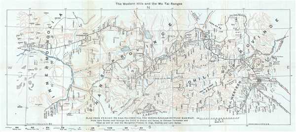
Plan From Peking to Pao-To-Chen via the Peking-Kalgan-Suiyan Railway.
1924 (undated) 12 x 26.5 in (30.48 x 67.31 cm) 1 : 1000000
1924 (undated) 12 x 26.5 in (30.48 x 67.31 cm) 1 : 1000000
Description
This is a 1924 Fei-Shi route map of the Beijing-Baotou railway, also known as the Peking-Kalgan-Suiyan Railway from Peking to Pao-To-Chen. The map depicts the region from Beijing (Peking) to Baotou (Paotow Chen). Highly detailed, numerous locations along the rail line are labeled, including the main stops at Zhangjiakou (Kalgan) and the terminus at Baotou (Paotow). Both the Outer and Inner Great Wall of China snake their way across the map from Beijing, stopping at the Yellow River, which forms part of the border with Inner Mongolia. Several roads and other railways are illustrated, along with canals, rivers, and lakes.
The Beijing – Baotou Railway, as it is referred to today, stretches over 500 miles from Beijing to Baotou. The Imperial Peking – Kalgan Railway was the first section of this railway and was constructed between 1905 and 1909, connecting Beijing and Zhangjiakou. This was the first railway designed and built by Chinese. The railway was extended from Zhangjiakou beginning in 1921 and reached Baotou by 1923. Today, this line has been mostly abandoned in favor of another, the Fengsha railway, which was built in the 1950s.
This map was produced for Fei-Shi's Guide to Peking and its Environs and published in 1924.
Source
Fei-Shi, Guide to Peking and its Environs Near and Far, (Tientsin and Peking: Tientsin Press) 1924.
Condition
Very good. Blank on verso.